 view gallery view gallery NE1.1 km NE1.1 km
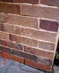
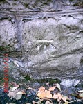
|   Rivet - St Michael and All Angels Church, Trelawnyd, Flintshire, Wales Rivet - St Michael and All Angels Church, Trelawnyd, Flintshire, Wales
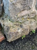
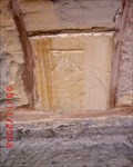
in U.K. and Ireland Trigpoints Rivet: W face St Michael and All Angels church, Trelawnyd, Flintshire, Wales. posted by:  Meirion Meirion location: North Wales, United Kingdom date approved: 01/28/2023 last visited: never |
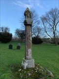 view gallery view galleryNE1.1 km |  Cross - St Michael & All Angels, Trelawnyd, Flintshire, Wales Cross - St Michael & All Angels, Trelawnyd, Flintshire, Wales
in Churchyard Crosses A Medieval cross in churchyard, Trelawnyd, Flintshire, Wales. posted by: Meirion location: North Wales, United Kingdom date approved: 01/25/2023 last visited: never |
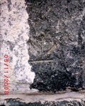
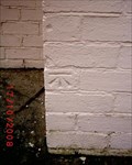
 view gallery view gallery NW1.9 km NW1.9 km
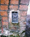
| Fundamental Benchmark, Dyserth, Denbighshire, Wales in U.K. and Ireland Trigpoints FBM: Graig Fawr, Dyserth, Denbighshire, Wales. posted by: Meirion location: United Kingdom date approved: 11/10/2008 last visited: never |
 view gallery view gallery E1.9 km E1.9 km
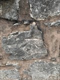
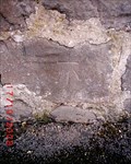
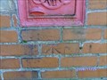
| Cut Mark - Angorfa, Marian, Flintshire, Wales in U.K. and Ireland Trigpoints Cut mark: On boundary wall of house 'Angorfa' on the NW side of road, Marian, Flintshire, Wales. posted by: Meirion location: North Wales, United Kingdom date approved: 01/13/2023 last visited: never |
 view gallery view galleryNW1.9 km | Dyserth, Mount House in U.K. and Ireland Trigpoints Cut mark: Wall (of Mount House) NW side Road 23.5m NE building opposite, Dyserth, Denbighshire. posted by: Meirion location: United Kingdom date approved: 11/16/2008 last visited: never |
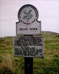 view gallery view galleryNW1.9 km |  Graig Fawr, Prestatyn, Denbighshire, Wales Graig Fawr, Prestatyn, Denbighshire, Wales
in National Trust U.K. A rocky outcrop near Prestatyn, Denbighshire, Wales. posted by: Meirion location: North Wales, United Kingdom date approved: 11/06/2008 last visited: 04/17/2017 |
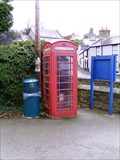
 view gallery view gallery W2.1 km W2.1 km
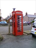
|  Red Kiosk, Y Bodunig Inn, Dyserth, Denbighshire, Wales Red Kiosk, Y Bodunig Inn, Dyserth, Denbighshire, Wales
in Red Telephone Boxes A red kiosk in the car park of Y Bodunig Inn, Dyserth, Denbighshire, Wales. posted by: Meirion location: North Wales, United Kingdom date approved: 12/07/2008 last visited: 04/19/2017 |
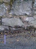
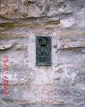
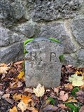
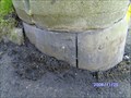
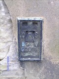 view gallery view galleryW2.1 km | Flush Bracket - Old Prengwyn Shop, Dyserth, Denbighshire, Wales in U.K. and Ireland Trigpoints Flush Bracket: On (old) Shop, Prengwyn Store on High Street E face SE angle, Dyserth, Denbighshire, Wales. posted by: Meirion location: United Kingdom date approved: 01/13/2009 last visited: never |
 view gallery view galleryW2.3 km | Red Kiosk, Dyserth, Denbighshire, Wales in Red Telephone Boxes A red kiosk near car park, Dyserth, Denbighshire, Wales. posted by: Meirion location: North Wales, United Kingdom date approved: 12/04/2008 last visited: 10/22/2010 |
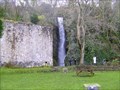 view gallery view galleryW2.3 km |  Dyserth Waterfall, Dyserth, Denbighshire, Wales Dyserth Waterfall, Dyserth, Denbighshire, Wales
in Waterfalls An impressive waterfall in Dyserth, Denbighshire, Wales. posted by: Meirion location: North Wales, United Kingdom date approved: 12/08/2008 last visited: 04/11/2014 |
 view gallery view galleryW2.3 km | Dyserth, Waterfall Road in U.K. and Ireland Trigpoints Cut mark: Stone wall E side Waterfall Road 6.1m N wall junction W face, Dyserth, Denbighshire. posted by: Meirion location: United Kingdom date approved: 12/30/2008 last visited: never |
 view gallery view galleryNW2.4 km | Dyserth, Graig Fawr Railway Bridge in U.K. and Ireland Trigpoints On E face Railway Bridge 1.2m SE angle, Dyserth, Denbighshire. posted by: Meirion location: United Kingdom date approved: 11/22/2008 last visited: 10/19/2010 |
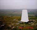 view gallery view galleryNW2.4 km | Graig Fawr Triangulation Pillar, Dyserth, Denbighshire, Wales in U.K. and Ireland Trigpoints A Triangulation Pillar, Nr Dyserth, Denbighshire, Wales. posted by: Meirion location: United Kingdom date approved: 11/13/2008 last visited: 04/17/2017 |
 view gallery view galleryNW2.6 km | Cut Mark - Old School, Meliden, Denbighshire, Wales in U.K. and Ireland Trigpoints Cut mark: (Old) School NE face 1.8m E angle, Meliden, Denbighshire, Wales. posted by: Meirion location: United Kingdom date approved: 12/06/2008 last visited: never |
 view gallery view galleryNW2.6 km | Meliden, St. Melyd's Church in U.K. and Ireland Trigpoints On St. Melyd's Church 2.4m SW angle W face, Meliden, Denbighshire. posted by: Meirion location: United Kingdom date approved: 12/06/2008 last visited: never |
 view gallery view galleryNW3.1 km | Prestatyn, Calthorpe Drive in U.K. and Ireland Trigpoints Cut mark: On wall 4.6m S projection S face No. 11A Calthorpe Drive, Prestatyn, Denbighshire. posted by: Meirion location: North Wales, United Kingdom date approved: 12/12/2008 last visited: never |
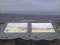 view gallery view gallery N3.1 km N3.1 km
|  Gwaenysgor Viewpoint Gwaenysgor Viewpoint
in Scenic Roadside Look-Outs This is a small roadside viewpoint with parking and breathtaking views over the nearby towns of Rhyl and Prestatyn. On a clear day its just possible to see the Isle of Man and Cumbria. posted by: The Web Rat location: North Wales, United Kingdom date approved: 08/07/2010 last visited: 04/25/2018 |
 view gallery view galleryN3.2 km | Prestatyn, 1 # Bryntirion Avenue in U.K. and Ireland Trigpoints Cut mark: NBM No. 1 Bryntirion Avenue NE side Stoneby Drive W angle, Prestatyn, Denbighshire. posted by: Meirion location: United Kingdom date approved: 11/03/2008 last visited: never |
 view gallery view galleryNW3.2 km | Prestatyn, 4 # The Avenue in U.K. and Ireland Trigpoints Cut mark: On gatepost SE side entrance No.4 The Avenue, Prestatyn, Denbighshire. posted by: Meirion location: North Wales, United Kingdom date approved: 12/19/2008 last visited: never |
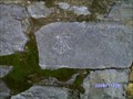
 view gallery view galleryW3.2 km |  Boundary Stone - A5151, Dyserth, Denbighshire, Wales Boundary Stone - A5151, Dyserth, Denbighshire, Wales
in Public Land Survey Marks A boundary stone located between Dyserth and Rhuddlan, Denbighshire, Wales. posted by: Meirion location: North Wales, United Kingdom date approved: 12/30/2022 last visited: never |
 view gallery view galleryNW3.2 km | Prestatyn, 6 # Coed Môr Drive in U.K. and Ireland Trigpoints Cut mark: No.6 Coed Môr Drive N angle, Prestatyn, Denbighshire. posted by: Meirion location: United Kingdom date approved: 12/06/2008 last visited: never |
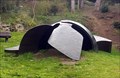 view gallery view galleryN3.4 km |  Roman Helmet Roman Helmet
in Realistic Object Sculptures A sculpture of a giant Roman helmet which marks the start / end of the Offa's Dyke, a long distance path. posted by: The Web Rat location: North Wales, United Kingdom date approved: 08/02/2010 last visited: 04/25/2018 |
 view gallery view galleryN3.4 km | Prestatyn, Post on Mount Ida Road in U.K. and Ireland Trigpoints Cut mark: Post NE end wall SE side (Mount Ida) at Road junction, Prestatyn, Denbighshire. posted by: Meirion location: United Kingdom date approved: 12/27/2008 last visited: never |
 view gallery view galleryN3.4 km | Prestatyn, Fforddlas, Letterbox in U.K. and Ireland Trigpoints Cut mark: On wall under Letterbox on the SW side Fforddlas at wall junction NE face, Prestatyn, Denbighshire. posted by: Meirion location: North Wales, United Kingdom date approved: 12/22/2008 last visited: never |
 view gallery view galleryN3.4 km | Prestatyn, Bryntirion Drive in U.K. and Ireland Trigpoints Cut mark: Wall SW side Road (Bryntirion Drive) junction NE face, Prestatyn, Denbighshire. posted by: Meirion location: United Kingdom date approved: 12/12/2008 last visited: never |
|