 view gallery view gallery SW1.4 km SW1.4 km
|   Buffalo Twins - Lloydminster, AB Buffalo Twins - Lloydminster, AB
in Murals Here is a huge mural that totally blew us away. In the area of Lloydminster, AB/SK, this is an absolute must see. posted by:  T0SHEA T0SHEA location: Alberta, Canada date approved: 12/29/2012 last visited: 02/12/2014 |
 view gallery view gallerySW1.4 km |  Buffalo Twins - Lloydminster, AB Buffalo Twins - Lloydminster, AB
in Mosaics Here is a huge mosaic that totally blew us away. In the area of Lloydminster, AB/SK, this is an absolute must see. posted by: T0SHEA location: Alberta, Canada date approved: 12/29/2012 last visited: 02/13/2014 |
 view gallery view gallery NE1.8 km NE1.8 km
|  Saskatchewan / Alberta Provincial Border crossing #1 Saskatchewan / Alberta Provincial Border crossing #1
in Border Crossings One of the view borders anywhere that actually cuts a town in half - that of the town of Lloydminster. posted by:  StagsRoar StagsRoar location: Saskatchewan, Canada date approved: 05/27/2006 last visited: 08/29/2018 |
 view gallery view gallery E2.3 km E2.3 km
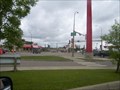
|  St. John's St. John's
in Saskatchewan Historical Markers A few steps away this marker is located on the the old church. posted by: Altima Voyageur location: Saskatchewan, Canada date approved: 09/29/2010 last visited: 12/25/2013 |
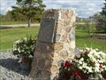
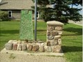 view gallery view galleryE2.3 km | Oil and Gas in Saskatchewan Historical Markers Oil and Gas Discoveries, located in the middle of two other cairns. Enjoy posted by: Altima Voyageur location: Saskatchewan, Canada date approved: 09/28/2010 last visited: 02/22/2014 |
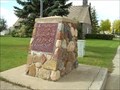 view gallery view galleryE2.3 km | George Exton Lloyd National Historic Monument in Saskatchewan Historical Markers George Exton Lloyd an Anglican missionary and teacher, Chaplain onwards to become Principal and onto Bishop of Saskatchewan. posted by: Altima Voyageur location: Saskatchewan, Canada date approved: 09/28/2010 last visited: 08/28/2018 |
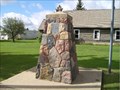 view gallery view galleryE2.3 km | One mile marker in Saskatchewan Historical Markers This waymark is located in the same vicinity of the three other plaques. posted by: Altima Voyageur location: Saskatchewan, Canada date approved: 09/28/2010 last visited: 02/22/2014 |
 view gallery view gallery N4.2 km N4.2 km
| Barr Colony Campsite in Saskatchewan Historical Markers Barr Colony Campsite just a short distance north on the skirt of the city. Inside the Saskatchewan side of Lloydminster. posted by: Altima Voyageur location: Saskatchewan, Canada date approved: 09/28/2010 last visited: 02/22/2014 |
 view gallery view gallery W11.3 km W11.3 km
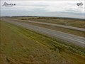
|  Lloydminster Traffic Webcam - Lloydminster, AB Lloydminster Traffic Webcam - Lloydminster, AB
in Web Cameras Hiway 16, Near Lloydminster and East of Hiway 897. posted by: T0SHEA location: Alberta, Canada date approved: 11/06/2013 last visited: 05/26/2014 |
 view gallery view gallery SE18.5 km SE18.5 km
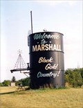
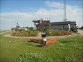
|  Welcome to Marshall: Black Gold Country - Marshall, Saskatchewan Welcome to Marshall: Black Gold Country - Marshall, Saskatchewan
in Welcome Signs Marshall is located approximately 16 km southeast of Lloydminster on the Yellowhead Hwy. The Marshall welcome sign is located at the north end of town on the Yellowhead Hwy. It sits up on a knoll, so look up and you cannot miss it. posted by: T0SHEA location: Saskatchewan, Canada date approved: 12/13/2012 last visited: 08/16/2021 |
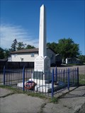 view gallery view gallerySE18.5 km |  Marshall War Memorial - Marshall, Saskatchewan Marshall War Memorial - Marshall, Saskatchewan
in Obelisks The war memorial is place in the middle of the street at Main Street and 1st Avenue W. posted by: T0SHEA location: Saskatchewan, Canada date approved: 12/16/2012 last visited: 01/28/2014 |
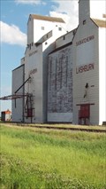
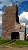
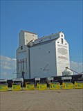 view gallery view gallerySE18.5 km |  Saskatchewan Wheat Pool Elevator - Marshall, Saskatchewan Saskatchewan Wheat Pool Elevator - Marshall, Saskatchewan
in Grain Elevators Marshall is a small town about 20 km southeast of Lloydminster, Saskatchewan, on Highway 16 aka The Yellowhead Highway. posted by: T0SHEA location: Saskatchewan, Canada date approved: 02/01/2013 last visited: 02/28/2014 |
 view gallery view galleryW21.6 km |  Alwyn Bramley-Moore Alwyn Bramley-Moore
in Alberta Heritage Markers Alwyn Bramley-Moore on Hwy 16, east of Kitscoty, Ab posted by: yellowmojo location: Alberta, Canada date approved: 08/30/2011 last visited: 12/24/2013 |
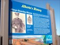
 view gallery view gallerySE31.7 km |  The Barr Colonists - Lashburn, Saskatchewan, Canada The Barr Colonists - Lashburn, Saskatchewan, Canada
in UK Historical Markers An historical marker about the Barr Colonists is located in the Centennial Garden along the access road adjacent to Trans-Canada Highway 16 in Lashburn, Saskatchewan, Canada. posted by: Marine Biologist location: Saskatchewan, Canada date approved: 08/02/2013 last visited: 06/29/2015 |
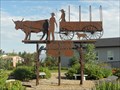 view gallery view gallerySE31.7 km |  Barr Colonists - Lashburn, Saskatchewan, Canada Barr Colonists - Lashburn, Saskatchewan, Canada
in Silhouette Public Art Sculptures This silhouette sculpture features a scene of a traveling pioneer family and is located in Centennial Garden which is along the access road adjacent to Trans-Canada Highway 16 in Lashburn, Saskatchewan, Canada. posted by: Marine Biologist location: Saskatchewan, Canada date approved: 08/02/2013 last visited: 06/29/2015 |
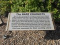
 view gallery view gallerySE31.7 km |  Barr Colonists - Lashburn, Saskatchewan, Canada Barr Colonists - Lashburn, Saskatchewan, Canada
in Human Migration Monuments A memorial to the Barr Colonists is located in the Centennial Garden along the access road adjacent to Trans-Canada Highway 16 in Lashburn, Saskatchewan, Canada. posted by: Marine Biologist location: Saskatchewan, Canada date approved: 08/02/2013 last visited: 06/29/2015 |
 view gallery view gallerySE31.7 km | Saskatchewan Wheat Pool Elevator, Lashburn, Saskatchewan in Grain Elevators Lashburn is about 34 km.south east of Lloydminster, AB/SK, on the Yellowhead Highway - aka Highway 16. posted by: T0SHEA location: Saskatchewan, Canada date approved: 02/01/2013 last visited: 06/29/2015 |
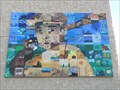 view gallery view gallerySE31.7 km | Baseball Player - Lashburn, Saskatchewan in Murals This mural consists of a "mosaic" of 96 wood tiles painted by local students and community members to create an old-time looking baseball player in recognition of the importance of baseball to the town. posted by: Marine Biologist location: Saskatchewan, Canada date approved: 08/02/2013 last visited: 02/22/2014 |
 view gallery view galleryNE36.7 km |  NHP Big Bear NHP Big Bear
in Canadian National Historic Sites This national historic person, is located on the back side of the Fort Pitt National Site cairn at the Fort Pitt Provincial Historic Site. posted by: Altima Voyageur location: Saskatchewan, Canada date approved: 10/05/2017 last visited: never |
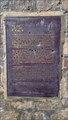
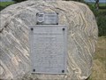
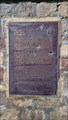 view gallery view galleryNE36.7 km | Big Bear in Saskatchewan Historical Markers This is located on the back side of the Fort
Pitt Historical Cairn at Fort Pitt. posted by: Altima Voyageur location: Saskatchewan, Canada date approved: 09/16/2017 last visited: never |
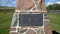
 view gallery view galleryNE36.7 km | CNHS Fort Pitt in Canadian National Historic Sites West of French Butte. Big Bear Monument is on other side of cairn. posted by: Altima Voyageur location: Saskatchewan, Canada date approved: 09/21/2017 last visited: never |
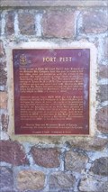
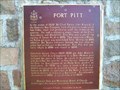 view gallery view galleryNE36.7 km | Fort Pitt in Saskatchewan Historical Markers Fort Pitt Provincial Historic Park, west of Paradise Hill near the Alberta border. posted by: Altima Voyageur location: Saskatchewan, Canada date approved: 09/22/2009 last visited: never |
 view gallery view galleryNE36.9 km | R. H. Hougham in Saskatchewan Historical Markers Located inside the Fort Pit historical site is a cairn describing God's Half Acre. posted by: Altima Voyageur location: Saskatchewan, Canada date approved: 09/16/2017 last visited: never |
 view gallery view galleryE39.1 km | Pike's Peak in Saskatchewan Historical Markers Pike's Peak is a hill with a Gus Kenderdine memorial rock sitting on top. posted by: JR@Southfork location: Saskatchewan, Canada date approved: 07/24/2006 last visited: 08/19/2009 |
 view gallery view gallerySE41.5 km |  Saskatchewan Wheat Pool B - Waseca, SK Saskatchewan Wheat Pool B - Waseca, SK
in Ghost Signs The last time anyone bothered to count, Waseca was home to 144 souls, living in 68 dwellings. All these dwellings are in the vicinity of 40 km. southeast of Lloydminster, which is on the Saskatchewan-Alberta border. posted by: T0SHEA location: Saskatchewan, Canada date approved: 02/07/2013 last visited: 02/22/2014 |
|