 view gallery view gallery N3.2 km N3.2 km
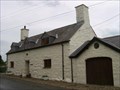
|   Tyn-y-Porth - Llangybi, Gwynedd, North Wales, UK Tyn-y-Porth - Llangybi, Gwynedd, North Wales, UK
in Pre-Victorian Historic Homes An old Welsh farmhouse in a small village in Gwynedd. posted by:  Dragontree Dragontree location: North Wales, United Kingdom date approved: 06/30/2008 last visited: never |
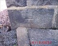
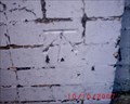
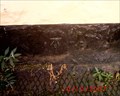
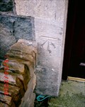
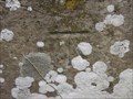 view gallery view galleryN3.2 km |  Cut Mark - St Cybis Church, Llangybi, Gwynedd, North Wales Cut Mark - St Cybis Church, Llangybi, Gwynedd, North Wales
in U.K. and Ireland Trigpoints A Cut Mark on the old church of St Cybis in Llangybi. posted by: Dragontree location: North Wales, United Kingdom date approved: 06/29/2008 last visited: never |
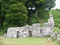 view gallery view galleryN3.2 km |  Ffynnon Gybi - Llangybi, Gwynedd, North Wales, UK Ffynnon Gybi - Llangybi, Gwynedd, North Wales, UK
in Holy Wells A fantastic old Holy Well hidden in Llangybi village. posted by: Dragontree location: North Wales, United Kingdom date approved: 07/01/2008 last visited: never |
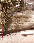
 view gallery view gallery E4.2 km E4.2 km
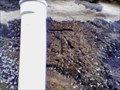
| Cut Mark - St John's Church, Llanystumdwy, Gwynedd, North Wales in U.K. and Ireland Trigpoints A Cut Mark on the old church of St John in the village of Llanystumdwy. posted by: Dragontree location: North Wales, United Kingdom date approved: 06/29/2008 last visited: never |
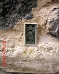
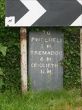 view gallery view galleryE4.2 km |  Llanystumdwy Milestone - Gwynedd, North Wales, UK Llanystumdwy Milestone - Gwynedd, North Wales, UK
in Milestones A slate milestone on the old bridge in the village of Llanystumdwy. posted by: Dragontree location: North Wales, United Kingdom date approved: 06/29/2008 last visited: never |
 view gallery view galleryE4.3 km |  David Lloyd George - Llanystumdwy, Gwynedd, North Wales, UK David Lloyd George - Llanystumdwy, Gwynedd, North Wales, UK
in Presidential Birthplaces David Lloyd George was a British Liberal politician and statesman. He was Prime Minister of the United Kingdom at the head of a wartime coalition government between the years 1916–22 and was the Leader of the Liberal Party from 1926–31. posted by: Dragontree location: North Wales, United Kingdom date approved: 08/01/2011 last visited: never |
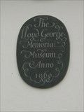
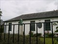 view gallery view galleryE4.3 km |  Lloyd George Museum - Llanystumdwy, Gwynedd, North Wales, UK Lloyd George Museum - Llanystumdwy, Gwynedd, North Wales, UK
in History Museums A small museum in the village of Llanystumdwy dedicated to the history of Lloyd George. posted by: Dragontree location: North Wales, United Kingdom date approved: 06/29/2008 last visited: never |
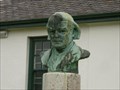 view gallery view galleryE4.3 km |  David Lloyd George - Llanystumdwy, Gwynedd, North Wales, UK David Lloyd George - Llanystumdwy, Gwynedd, North Wales, UK
in Statues of Historic Figures A bust of the Prime Minister David Lloyd George. posted by: Dragontree location: North Wales, United Kingdom date approved: 06/28/2008 last visited: never |
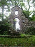 view gallery view galleryE4.3 km |  David Lloyd George - Prime Minister - Llanystumdwy, Gwynedd, North Wales, UK David Lloyd George - Prime Minister - Llanystumdwy, Gwynedd, North Wales, UK
in Grave of a Famous Person The large grave and memorial of Prime Minister David Lloyd George. posted by: Dragontree location: North Wales, United Kingdom date approved: 06/29/2008 last visited: 01/06/2013 |
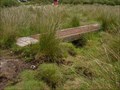 view gallery view galleryE4.5 km |  Plank Bridge - Afon Dwyfor, Criccieth, Gwynedd, North Wales, UK Plank Bridge - Afon Dwyfor, Criccieth, Gwynedd, North Wales, UK
in Hiking Path Footbridges A small plank bridge taking a trail through the peat bog alongside the River Dwyfor. posted by: Dragontree location: North Wales, United Kingdom date approved: 06/28/2008 last visited: never |
 view gallery view gallery SW6 km SW6 km
| Pwllheli, Bryn Hyfryd GTP in U.K. and Ireland Trigpoints Cut mark: On gatepost at Bryn Hyfryd S side road 3.2m NE wall junction, Pwllheli, Gwynedd. posted by: Meirion location: North Wales, United Kingdom date approved: 10/13/2007 last visited: 10/10/2007 |
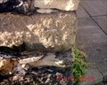
 view gallery view galleryE6.1 km | Criccieth, Railway Bridge in U.K. and Ireland Trigpoints Cut mark: Railway Bridge SW side Road 2m NW fence junction, Criccieth, Gwynedd. posted by: Meirion location: United Kingdom date approved: 05/08/2008 last visited: never |
 view gallery view gallerySW6.1 km | Pwllheli, High Street in U.K. and Ireland Trigpoints Cut mark: NBM No. 4 High Street E face NE angle, Pwllheli, Gwynedd. posted by: Meirion location: North Wales, United Kingdom date approved: 10/12/2007 last visited: 10/10/2007 |
 view gallery view gallerySW6.4 km | Pwllheli, Tower Hotel in U.K. and Ireland Trigpoints Cut mark: The Tower Hotel on Stryd Fawr SE face 3.8m S angle, Pwllheli, Gwyned posted by: Meirion location: North Wales, United Kingdom date approved: 10/12/2007 last visited: 10/10/2007 |
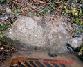 view gallery view galleryE6.4 km | Criccieth, Boulder in U.K. and Ireland Trigpoints Cut mark: Stone NE side Road 2m NW wall junction, Criccieth, Gwynedd.
posted by: Meirion location: United Kingdom date approved: 05/07/2008 last visited: never |
 view gallery view gallerySW6.4 km |  Pwllheli, Allt Salem Anchor Pwllheli, Allt Salem Anchor
in Anchors An anchor situated in the coastal town on Pwllheli, Gwynedd, Wales. posted by: Meirion location: North Wales, United Kingdom date approved: 10/21/2007 last visited: never |
 view gallery view galleryE6.4 km | Criccieth, Sea Bank Hotel in U.K. and Ireland Trigpoints On Sea Bank Hotel NW side Road NE face 0.8m E angle, Criccieth, Gwynedd. posted by: Meirion location: United Kingdom date approved: 05/05/2008 last visited: never |
 view gallery view gallerySW6.4 km | Pwllheli, Salem Terrace in U.K. and Ireland Trigpoints Cut mark: At front of house on Salem Terrace, Pwllheli, Gwynedd. posted by: Meirion location: North Wales, United Kingdom date approved: 10/13/2007 last visited: 10/10/2007 |
 view gallery view galleryE6.4 km |  Y Castell – Criccieth, North Wales, UK Y Castell – Criccieth, North Wales, UK
in Pictorial Pub Signs Picture of nearby Criccieth Castle on the headland above the town of Criccieth. posted by: dtrebilc location: North Wales, United Kingdom date approved: 05/17/2011 last visited: never |
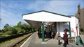 view gallery view galleryE6.4 km |  Criccieth Station – North Wales, UK Criccieth Station – North Wales, UK
in Train Stations/Depots Criccieth is a Welsh railway station on the Cambrian Coast Line. posted by: dtrebilc location: Yorkshire, United Kingdom date approved: 06/08/2011 last visited: 04/13/2014 |
 view gallery view galleryE6.4 km | Criccieth, Post Office in U.K. and Ireland Trigpoints Cut mark: Post Office SE side High Street N angle NE face, Criccieth, Gwynedd. posted by: Meirion location: United Kingdom date approved: 05/05/2008 last visited: never |
 view gallery view gallerySW6.4 km | Pwllheli, White Hall Public House in U.K. and Ireland Trigpoints Cut mark: On the White Hall public house SW side road junction N face 6m NE angle, Pwllheli, Gwynedd. posted by: Meirion location: North Wales, United Kingdom date approved: 10/10/2007 last visited: 10/10/2007 |
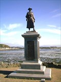 view gallery view gallerySW6.4 km |  Pwllheli War Memorial, Pwllheli, Gwynedd, Wales Pwllheli War Memorial, Pwllheli, Gwynedd, Wales
in World War I Memorials and Monuments A war memorial overlooking Pwllheli harbour, Gwynedd, Wales. posted by: Meirion location: North Wales, United Kingdom date approved: 10/24/2007 last visited: never |
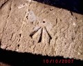 view gallery view gallerySW6.4 km | Pwllheli, Tidal Gate in U.K. and Ireland Trigpoints Rivet: On parapet of Tidal Gates SW side road 1m N wall junction, Pwllheli, Gwynedd. posted by: Meirion location: North Wales, United Kingdom date approved: 10/10/2007 last visited: 10/10/2007 |
 view gallery view galleryE6.6 km | Criccieth, 4 # Victoria Terrace in U.K. and Ireland Trigpoints Cut mark: House No. 4 Victoria Terrace NE side Road S angle SW face, Criccieth, Gwynedd.
posted by: Meirion location: United Kingdom date approved: 05/10/2008 last visited: never |
|