 view gallery view gallery SE1.1 km SE1.1 km
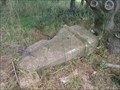
|   Triangulation Pillar S4352 - Sutton Hoo, Suffolk Triangulation Pillar S4352 - Sutton Hoo, Suffolk
in European Historic Survey Stones, Monuments and Benchmarks Triangulation pillar S4352 on a footpath leading to the Sutton Hoo burial mounds. posted by:  SMacB SMacB location: Eastern England, United Kingdom date approved: 08/21/2015 last visited: never |
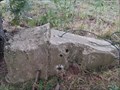 view gallery view gallerySE1.1 km |  Triangulation Pillar S4352 - Sutton Hoo, Suffolk Triangulation Pillar S4352 - Sutton Hoo, Suffolk
in U.K. and Ireland Trigpoints Triangulation pillar S4352 on a footpath leading to the Sutton Hoo burial mounds. posted by: SMacB location: Eastern England, United Kingdom date approved: 08/21/2015 last visited: never |
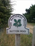 view gallery view gallerySE1.1 km |  Sutton Hoo - Sutton Hoo, Suffolk Sutton Hoo - Sutton Hoo, Suffolk
in National Trust U.K. NT marker just outside the enclosure for the Sutton Hoo burial site. posted by: SMacB location: Eastern England, United Kingdom date approved: 08/25/2015 last visited: never |
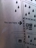
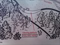 view gallery view gallery S1.1 km S1.1 km
|  You Are Here - Sutton Hoo Burial Ground - Sutton Hoo, Suffolk You Are Here - Sutton Hoo Burial Ground - Sutton Hoo, Suffolk
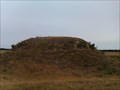
in 'You Are Here' Maps Although only a small part of the cemetery was excavated, the high proportion of 'warrior' status burials marks this cemetery out as something special. The relationship between the two cemeteries is open to debate, but it leads one to consider if this above-river escarpment at Sutton Hoo might have developed as an early Anglo-Saxon established ritual landscape, marking out one cemetery for high standing individuals and a separate cemetery reserved for the ruling elite. posted by: SMacB location: Eastern England, United Kingdom date approved: 08/22/2015 last visited: never |
 view gallery view galleryS1.1 km |  Sutton Hoo Burial Ground - Sutton Hoo, Suffolk Sutton Hoo Burial Ground - Sutton Hoo, Suffolk
in UK Historical Markers Although only a small part of the cemetery was excavated, the high proportion of 'warrior' status burials marks this cemetery out as something special. The relationship between the two cemeteries is open to debate, but it leads one to consider if this above-river escarpment at Sutton Hoo might have developed as an early Anglo-Saxon established ritual landscape, marking out one cemetery for high standing individuals and a separate cemetery reserved for the ruling elite. posted by: SMacB location: Eastern England, United Kingdom date approved: 08/21/2015 last visited: 07/18/2023 |
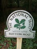 view gallery view gallerySE1.3 km | Sutton Hoo 'Wiffen Wood' - Sutton Hoo, Suffolk in National Trust U.K. NT marker sign for Sutton Hoo on the B1083. posted by: SMacB location: Eastern England, United Kingdom date approved: 08/25/2015 last visited: never |
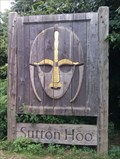 view gallery view gallerySE1.3 km |  Sutton Hoo - B1083 - Sutton Hoo, Suffolk Sutton Hoo - B1083 - Sutton Hoo, Suffolk
in Relief Art Sculptures Wooden sign with relief image of the Sutton Hoo Helmet, on the B1083, Suffolk, near the entrance roadway to the Sutton Hoo centre. posted by: SMacB location: Eastern England, United Kingdom date approved: 08/24/2015 last visited: never |
 view gallery view gallery SW1.4 km SW1.4 km
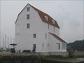
|  Woodbridge Tide Mill Woodbridge Tide Mill
in Working Water Wheels One of the oldest, and possibly the last working tide mill in the United Kingdom. posted by: CEO44 location: Eastern England, United Kingdom date approved: 12/10/2014 last visited: 07/17/2023 |
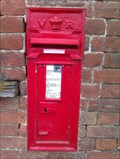
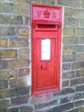 view gallery view gallerySW1.4 km |  Woodbridge Station Postbox, Woodbridge, Suffolk Woodbridge Station Postbox, Woodbridge, Suffolk
in Victorian Post Boxes A wall-mounted box in good condition. posted by: sTeamTraen location: Eastern England, United Kingdom date approved: 06/10/2014 last visited: 09/04/2014 |
 view gallery view gallery W2.1 km W2.1 km
|  Buttrum's Mill - Woodbridge, Suffolk Buttrum's Mill - Woodbridge, Suffolk
in Windmills Buttrum's Mill or Trott's Mill is a Grade II listed tower mill at Woodbridge, Suffolk, England which has been restored to working order. posted by: SMacB location: Eastern England, United Kingdom date approved: 03/30/2014 last visited: 09/04/2014 |
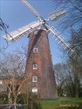 view gallery view galleryW2.1 km |  Buttrum's Mill - Woodbridge, Suffolk, England Buttrum's Mill - Woodbridge, Suffolk, England
in Wikipedia Entries Buttrum's Mill is one of England's finest tower windmills. Built in 1836, it was probably a wedding present to its first owner, Pierce Trott, who married in the same year. posted by: SMacB location: Eastern England, United Kingdom date approved: 03/31/2014 last visited: 09/04/2014 |
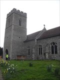
 W6.1 km |  Bell Tower - Church of St Mary, Stoney Road, Grundisburgh, Suffolk IP13 6TA Bell Tower - Church of St Mary, Stoney Road, Grundisburgh, Suffolk IP13 6TA
in Bell Towers Is this a church tower - or an C18th industrial water tower? Anyway it's got bells in it. posted by: greysman location: South East England, United Kingdom date approved: 05/24/2016 last visited: never |
 view gallery view gallery NW6.4 km NW6.4 km
| Bell Tower - Church of St.Botolph, Junction of B1079 and Drabs Lane, Burgh, Suffolk IP13 6QB in Bell Towers The main entrance to the church is through the door in the tower where the bells are hung. posted by: greysman location: South East England, United Kingdom date approved: 05/30/2016 last visited: never |
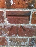
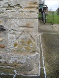 view gallery view galleryNW6.4 km | St.Botolph's Church, B1079, Burgh, Suffolk. IP13 6QA in U.K. and Ireland Trigpoints Well worn cut mark on the church tower. posted by: greysman location: South East England, United Kingdom date approved: 04/19/2016 last visited: never |
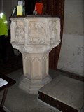 view gallery view galleryNW6.4 km |  Font - St.Botolph's Church, B1079, Burgh, Suffolk. IP13 6QA Font - St.Botolph's Church, B1079, Burgh, Suffolk. IP13 6QA
in Stone Church Artefacts An old octagonal font on a 'modern' stem. posted by: greysman location: South East England, United Kingdom date approved: 04/23/2016 last visited: never |
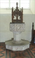 view gallery view galleryNW6.8 km | Font - St Mary the Virgin, Grunisburgh Road, Clopton, Suffolk. IP13 6QB in Stone Church Artefacts An ornate timber font cover sits atop this old decorated font. posted by: greysman location: South East England, United Kingdom date approved: 04/25/2016 last visited: never |
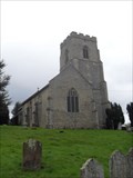 view gallery view galleryNW6.8 km | Bell Tower - Church of St Mary, Grundisburgh Road, Clopton, Suffolk. IP13 6QB in Bell Towers The bells here are rung from the first floor of the south-west tower which has the main church entrance on the ground floor. posted by: greysman location: South East England, United Kingdom date approved: 05/24/2016 last visited: never |
 view gallery view gallery E6.9 km E6.9 km
|  Crocodile - Rendlesham Forest, Suffolk Crocodile - Rendlesham Forest, Suffolk
in Outside Wooden Display Carvings A wooden crocodile along the UFO trail in Rendlesham Forest. posted by: SMacB location: Eastern England, United Kingdom date approved: 08/26/2015 last visited: never |
 view gallery view galleryE7.1 km |  Rendlesham UFO sightings - Rendlesham Forest, Suffolk Rendlesham UFO sightings - Rendlesham Forest, Suffolk
in Weird Story Locations Did an extra-terrestrial craft land in a Suffolk forest during the winter of 1980?
Dubbed “Britain’s Roswell”, the Rendlesham Forest incident, which took place over a series of nights in December 1980, continues to fascinate UFO enthusiasts. posted by: SMacB location: Eastern England, United Kingdom date approved: 08/19/2015 last visited: never |
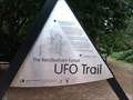
 view gallery view galleryE7.1 km | You Are Here - Rendlesham Forest, Suffolk in 'You Are Here' Maps You are here map in Rendlesham Forest. Dubbed “Britain’s Roswell”, the Rendlesham Forest incident, which took place over a series of nights in December 1980, continues to fascinate UFO enthusiasts and conspiracy theorists. posted by: SMacB location: Eastern England, United Kingdom date approved: 08/20/2015 last visited: never |
 view gallery view galleryE9.3 km |  Capel St Andrew - Suffolk Capel St Andrew - Suffolk
in Pictorial Village Signs This unusual village sign was cmmissioned by the Parish Council to commemorate the millennium. The village sign/sculpture is situated at a crossroads by the side of a barn on Church Road, Capel St Andrew. posted by: SMacB location: Eastern England, United Kingdom date approved: 08/22/2015 last visited: never |
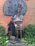 view gallery view galleryE9.3 km |  Village sign, Capel St Andrew - Suffolk Village sign, Capel St Andrew - Suffolk
in Made for the Millennium This unusual village sign was commissioned by the Parish Council to commemorate the millennium. The village sign/sculpture is situated at a crossroads by the side of a barn on Church Road, Capel St Andrew. posted by: SMacB location: Eastern England, United Kingdom date approved: 08/25/2015 last visited: never |
 view gallery view galleryE9.3 km | Victorian Post Box - Capel St Andrew, Suffolk in Victorian Post Boxes A victorian post box on Royton Road, on the side of an old barn, Capel St Andrew. posted by: SMacB location: Eastern England, United Kingdom date approved: 08/20/2015 last visited: never |
 view gallery view galleryE9.3 km |  St Andrew - Capel St Andrew, Suffolk St Andrew - Capel St Andrew, Suffolk
in Statues of Religious Figures This unusual village sign, a depiction of St Andrew, was commissioned by the Parish Council to commemorate the millennium. The village sign/sculpture is situated at a crossroads by the side of a barn on Church Road, Capel St Andrew. posted by: SMacB location: Eastern England, United Kingdom date approved: 08/24/2015 last visited: never |
 view gallery view galleryE9.3 km | Benchmark, St Andrew - Boyton, Suffolk in European Historic Survey Stones, Monuments and Benchmarks Cut benchmark on the south west corner of the church tower. St Andrew's, Boyton. posted by: SMacB location: Eastern England, United Kingdom date approved: 08/21/2015 last visited: never |
|