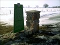
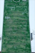
 view gallery view gallery SE43.6 km SE43.6 km
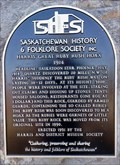
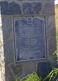
|   Harris' Great Ruby Rush Hoax Harris' Great Ruby Rush Hoax
in Saskatchewan Historical Markers Located in the town called Harris. Off the Highway 7, located corner of Main Street and Railway Avenue. posted by:  Altima Voyageur Altima Voyageur location: Saskatchewan, Canada date approved: 05/10/2015 last visited: never |
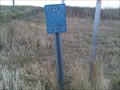
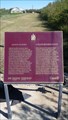
 view gallery view gallery SW43.9 km SW43.9 km
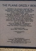
| The Plains Grizzly Bear in Saskatchewan Historical Markers Located in the small community of Herschel. posted by: Altima Voyageur location: Saskatchewan, Canada date approved: 04/12/2015 last visited: never |
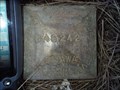
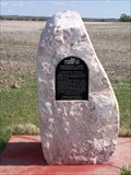
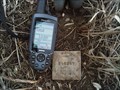 view gallery view gallerySE44.3 km |  84S247 84S247
in Canadian Benchmarks This is just a benchmark we discovered while out geocaching. posted by:  Dragonfly E&N Dragonfly E&N location: Saskatchewan, Canada date approved: 11/06/2009 last visited: 02/18/2010 |
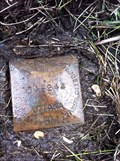 view gallery view gallerySE46.3 km | Benchmark - Geodetic Survey 84S244 in Canadian Benchmarks Benchmark - Geodetic Survey 84S244 posted by: Dragonfly E&N location: Saskatchewan, Canada date approved: 06/11/2012 last visited: never |
 view gallery view gallerySE46.7 km | 84S242 in Canadian Benchmarks A benchmark we discovered while out geocaching. posted by: Dragonfly E&N location: Saskatchewan, Canada date approved: 11/07/2009 last visited: 04/21/2012 |
 view gallery view gallery S47 km S47 km
| 84S238 in Canadian Benchmarks A benchmark we discovered while out geocaching. posted by: Dragonfly E&N location: Saskatchewan, Canada date approved: 11/07/2009 last visited: 04/21/2012 |
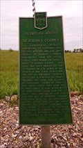 view gallery view gallery NW50.4 km NW50.4 km
| St. Joseph's Colony in Saskatchewan Historical Markers Located about 10 Kilometers South from Highway 14. Meters East of Grid Hwy 657. posted by: Altima Voyageur location: Saskatchewan, Canada date approved: 08/31/2014 last visited: never |
 view gallery view gallery E60.2 km E60.2 km
| Prince Albert, Red Deer Forks Trail in Saskatchewan Historical Markers This pull off is on the south side of the highway. posted by: Altima Voyageur location: Saskatchewan, Canada date approved: 03/23/2011 last visited: never |
 view gallery view gallery NE62.1 km NE62.1 km
| Maymont Bridge in Saskatchewan Historical Markers Bridge dedication by Saskatchewan Premier Allan E. Blakeney, June 20, 1976. posted by: Altima Voyageur location: Saskatchewan, Canada date approved: 09/26/2011 last visited: never |
 view gallery view galleryNE62.1 km | Eagle Hills Post in Saskatchewan Historical Markers This cairn is located in Glenburn Regional Park eight kilometers from Hwy 16. posted by: Altima Voyageur location: Saskatchewan, Canada date approved: 10/04/2011 last visited: never |
 view gallery view galleryE64.1 km | Benchmark - Geodetic Survey 1061-F in Canadian Benchmarks Benchmark - Geodetic Survey 1061-F posted by: Dragonfly E&N location: Saskatchewan, Canada date approved: 06/11/2012 last visited: 06/09/2014 |
 view gallery view galleryNW64.2 km | The Trampling Lake Portion of the Medicine Hat Trail in Saskatchewan Historical Markers Located on the Northeast side of Wilkie. posted by: Altima Voyageur location: Saskatchewan, Canada date approved: 08/31/2014 last visited: never |
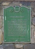
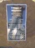 view gallery view gallery N69 km N69 km
| Village of Maymont in Saskatchewan Historical Markers Village of Maymont story about its naming. posted by: Altima Voyageur location: Saskatchewan, Canada date approved: 09/26/2011 last visited: never |
 view gallery view galleryNE76.6 km | Borden Bridge in Saskatchewan Historical Markers This site marks a refueling stop for boats travelling the Saskatchewan River well before the building of the bridge. posted by: StagsRoar location: Saskatchewan, Canada date approved: 05/28/2006 last visited: 11/02/2010 |
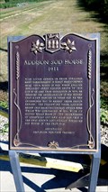
 view gallery view gallerySW76.8 km |  CNHS Addison House CNHS Addison House
in Canadian National Historic Sites National Historic Site Addison Sod House, is a house that was built over a hundred years ago and is still a habitable home. Located north of Kindersley on Hwy 21, then East on Gleneath Road, 10.6 kilometers. posted by: Altima Voyageur location: Saskatchewan, Canada date approved: 09/20/2017 last visited: never |
 view gallery view gallerySW76.8 km | Addison Sod House (National Site) in Saskatchewan Historical Markers Both a Provincial and National Site Addison Sod House historic site is a house that was built over a hundred years ago and is still a habitable home. Located north of Kindersley on Hwy 21, then East on Gleneath Road, 10.6 kilometers. posted by: Altima Voyageur location: Saskatchewan, Canada date approved: 09/16/2017 last visited: never |
 view gallery view gallerySW76.8 km | Addison Sod House (Provincial Site) in Saskatchewan Historical Markers Both and provincial and national site the Addison Sod House has lasted over a hundred years. Located north of Kindersley on Hwy 21, then East on Gleneath Road, 10.6 kilometers. posted by: Altima Voyageur location: Saskatchewan, Canada date approved: 09/16/2017 last visited: never |
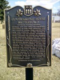
 view gallery view galleryNE76.9 km | Doukhobors Bogdanovka Cemetary in Saskatchewan Historical Markers This cemetary is all that remains of this historic village settlement of Russian refugees fleeing persecution from czarist Russia. posted by: Sask_girl & Novy location: Saskatchewan, Canada date approved: 05/24/2006 last visited: 06/01/2009 |
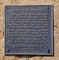 view gallery view galleryNE81.6 km | Doukhobor Heritage in Saskatchewan Historical Markers Located at a nature and viewpoint just off (Yellowhead) HWY 16. posted by: Altima Voyageur location: Saskatchewan, Canada date approved: 01/27/2016 last visited: 06/07/2023 |
 view gallery view galleryN82.2 km | 1877-1883 Government House Battleford in Saskatchewan Historical Markers Just as short drive up a hill then a quick switch back left turn to this location. posted by: Altima Voyageur location: Saskatchewan, Canada date approved: 06/18/2013 last visited: never |
 view gallery view galleryN82.2 km | Seat of the Territorial Government National Historic Monument~Seige du Gouvernement Territorial , 1878-1883 in Saskatchewan Historical Markers Walking distance to other North West Territory Government House waymark. This plaque is in rough shape. posted by: Altima Voyageur location: Alberta, Canada date approved: 06/19/2013 last visited: never |
 view gallery view galleryN82.4 km | CNHS Seat of the Territorial Government National Historic Monument~Seige du Gouvernement Territorial, 1878-1883 in Canadian National Historic Sites This is located a few kilometers southwest of the Town of Battleford. posted by: Altima Voyageur location: Saskatchewan, Canada date approved: 11/12/2017 last visited: never |
 view gallery view galleryN82.6 km | Telegraph Flat in Saskatchewan Historical Markers Short distance from Hwy 4 and new access Hwy 658. posted by: Altima Voyageur location: Saskatchewan, Canada date approved: 09/24/2009 last visited: never |
 view gallery view galleryN82.6 km | Saskatchewan Herald in Saskatchewan Historical Markers The Territories first newspaper. Located just off the new access to Hwy 658 a short grid road south of creek. A few meters off of Hwy 4. posted by: Altima Voyageur location: Saskatchewan, Canada date approved: 09/24/2009 last visited: never |
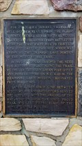
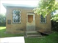 view gallery view galleryN82.7 km |  FIRST - Land Registry Office in Canada's North-West Territories FIRST - Land Registry Office in Canada's North-West Territories
in First of its Kind Not only is the Battleford Land Registry Office the first land registry office in the North-West Territories, but it is also the oldest known brick building in Saskatchewan. posted by: Marine Biologist location: Saskatchewan, Canada date approved: 07/30/2013 last visited: never |
|