 view gallery view gallery S29.6 km S29.6 km
|   Youngstown Highway Web Camera - Youngstown, Alberta Youngstown Highway Web Camera - Youngstown, Alberta
in Web Cameras This Alberta Highways Webcam is mounted on a steel tower along Highway 9 just west of Youngstown. posted by:  T0SHEA T0SHEA location: Alberta, Canada date approved: 03/03/2014 last visited: 07/28/2014 |
 view gallery view gallery NW31.5 km NW31.5 km
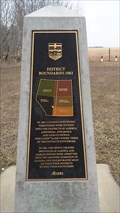
|   District of Boundaries District of Boundaries
in Alberta Heritage Markers Located 15 kilometers south of Coronation Alberta. posted by:  Altima Voyageur Altima Voyageur location: Alberta, Canada date approved: 05/04/2017 last visited: never |
 view gallery view gallery N46.2 km N46.2 km
|   The Neutral Hills The Neutral Hills
in Alberta Heritage Markers This cairn is 34 kilometers south of Czar on north side of Buffalo Trail (Hwy 41). Look for Historic signs. posted by:  Altima Voyageur Altima Voyageur location: Alberta, Canada date approved: 09/09/2017 last visited: never |
 view gallery view gallery SE51.5 km SE51.5 km
|   Oyen Highway Web Camera - Oyen, Alberta Oyen Highway Web Camera - Oyen, Alberta
in Web Cameras This Alberta Highways Webcam is mounted on a steel tower along Highway 9 about midway between Cereal and Oyen. posted by:  T0SHEA T0SHEA location: Alberta, Canada date approved: 03/03/2014 last visited: 07/28/2014 |
 view gallery view gallery W60.4 km W60.4 km
|   CNR Roundhouse - Hanna, AB CNR Roundhouse - Hanna, AB
in Railway Roundhouses Canadian Northern Railway, later to become part of the Canadian National Railway, built this roundhouse in Hanna, Alberta in 1913 as Hanna was made a divisional point for the railroad. posted by:  T0SHEA T0SHEA location: Alberta, Canada date approved: 07/24/2014 last visited: never |
 view gallery view gallery W60.4 km W60.4 km
|   Canadian Northern Railway Roundhouse - Hanna, AB Canadian Northern Railway Roundhouse - Hanna, AB
in Western Canadian Heritage Canadian Northern Railway, later to become part of the Canadian National Railway, built this roundhouse in Hanna, Alberta in 1913 when Hanna was made a divisional point for the railroad. posted by:  T0SHEA T0SHEA location: Alberta, Canada date approved: 03/28/2023 last visited: never |
 view gallery view gallery SE70 km SE70 km
|   Sibbald Highway Web Camera - Sibbald, Alberta Sibbald Highway Web Camera - Sibbald, Alberta
in Web Cameras This Alberta Highways Webcam is mounted on a steel tower along Highway 9 about midway between Oyen and Sibbald. posted by:  T0SHEA T0SHEA location: Alberta, Canada date approved: 03/03/2014 last visited: 08/04/2014 |
 view gallery view gallery W76.6 km W76.6 km
|   The Plan of Mr. Palliser - Hanna, AB The Plan of Mr. Palliser - Hanna, AB
in Alberta Heritage Markers On Highway 9, 17 km. west of Hanna is a pullout for one of the dozens of Alberta Heritage Markers strewn along the highways and byways of the province. posted by:  T0SHEA T0SHEA location: Alberta, Canada date approved: 07/06/2014 last visited: never |
 view gallery view gallery NW78.9 km NW78.9 km
|   Tourism Discovery Centre - Williams Lake, British Columbia Tourism Discovery Centre - Williams Lake, British Columbia
in Tourist Information Centers - Visitor Centers Tourism Discovery Centre includes the visitor centre and is located at 1660 Broadway Avenue S. posted by:  T0SHEA T0SHEA location: British Columbia, Canada date approved: 08/27/2019 last visited: never |
 view gallery view gallery NW80.6 km NW80.6 km
|   Highway 36 & TWP Road 392 South Highway Webcam - Alliance, AB Highway 36 & TWP Road 392 South Highway Webcam - Alliance, AB
in Web Cameras This Alberta Highways Webcam is mounted on a steel tower on the east side of Highway 16 south of the town of Alliance. posted by:  T0SHEA T0SHEA location: Alberta, Canada date approved: 03/05/2014 last visited: 08/03/2014 |
 view gallery view gallery NW80.6 km NW80.6 km
|   Highway 36 & TWP Road 392 Road Highway Webcam - Alliance, AB Highway 36 & TWP Road 392 Road Highway Webcam - Alliance, AB
in Web Cameras This Alberta Highways Webcam is mounted on a steel tower on the east side of Highway 16 south of the town of Alliance. posted by:  T0SHEA T0SHEA location: Alberta, Canada date approved: 03/05/2014 last visited: 08/03/2014 |
 view gallery view gallery NW80.6 km NW80.6 km
|   Highway 36 & TWP Road 392 North Highway Webcam - Alliance, AB Highway 36 & TWP Road 392 North Highway Webcam - Alliance, AB
in Web Cameras This Alberta Highways Webcam is mounted on a steel tower on the east side of Highway 16 south of the town of Alliance. posted by:  T0SHEA T0SHEA location: Alberta, Canada date approved: 03/05/2014 last visited: 08/03/2014 |
 view gallery view gallery W80.6 km W80.6 km
|   Craigmyle School - Craigmyle, AB Craigmyle School - Craigmyle, AB
in Former Schools Built in 1919, the Craigmyle School has been repurposed as a civic centre. In front of the old Craigmyle School is a stone cairn which was erected in 1927 as a World War I Memorial. posted by:  T0SHEA T0SHEA location: British Columbia, Canada date approved: 02/26/2015 last visited: never |
 view gallery view gallery W80.6 km W80.6 km
|   Craigmyle Village World War II Memorial - Craigmyle, AB Craigmyle Village World War II Memorial - Craigmyle, AB
in World War II Memorials / Monuments In front of the old Craigmyle School is a stone cairn which was erected in 1927, bearing two plaques - a World War I Memorial Plaque and a World War II Memorial Plaque. posted by:  T0SHEA T0SHEA location: Alberta, Canada date approved: 07/28/2014 last visited: never |
 view gallery view gallery W80.6 km W80.6 km
|   Craigmyle Village World War I Memorial - Craigmyle, AB Craigmyle Village World War I Memorial - Craigmyle, AB
in World War I Memorials and Monuments In front of the old Craigmyle School is a stone cairn which was erected in 1927, bearing two plaques - a World War I Memorial Plaque and a World War II Memorial Plaque. posted by:  T0SHEA T0SHEA location: Alberta, Canada date approved: 07/30/2014 last visited: never |
 view gallery view gallery W82.7 km W82.7 km
|   Craigmyle Highway Web Camera - Craigmyle, Alberta Craigmyle Highway Web Camera - Craigmyle, Alberta
in Web Cameras This Alberta Highways Webcam is mounted on a steel tower along Highway 9 at Range Road 170. posted by:  T0SHEA T0SHEA location: Alberta, Canada date approved: 03/03/2014 last visited: 07/27/2014 |
 view gallery view gallery W89.6 km W89.6 km
|   Delia Elevator Delia Elevator
in Grain Elevators Elevator and seed cleaning plant. posted by:  T0SHEA T0SHEA location: Alberta, Canada date approved: 09/12/2012 last visited: 01/07/2014 |
 view gallery view gallery W90 km W90 km
|   Starland Seed Plant - Delia, AB Starland Seed Plant - Delia, AB
in Grain Elevators This seed cleaning plant is on the north side of the town of Delia, on Main Street at Township Road 311. posted by:  T0SHEA T0SHEA location: Alberta, Canada date approved: 09/27/2014 last visited: never |
 view gallery view gallery NE98.3 km NE98.3 km
|   Saskatchewan / Alberta Provincial Border crossing #2 Saskatchewan / Alberta Provincial Border crossing #2
in Border Crossings This provincial crossing is between Macklin, Saskatchewan and Provost, Alberta. posted by:  StagsRoar StagsRoar location: Saskatchewan, Canada date approved: 06/04/2006 last visited: 06/10/2007 |
 view gallery view gallery NE99.6 km NE99.6 km
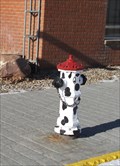
|   Dalmation hydrant - Macklin, Saskatchewan Dalmation hydrant - Macklin, Saskatchewan
in Painted Hydrants This dalmation fire hydrant is located on Main Street in Macklin Saskatchewan. posted by:  wildwoodke wildwoodke location: Saskatchewan, Canada date approved: 03/15/2012 last visited: never |
 view gallery view gallery NE99.6 km NE99.6 km
|   Peking Garden Family Restaurant - Macklin, Saskatchewan Peking Garden Family Restaurant - Macklin, Saskatchewan
in Chinese Restaurants This Chinese (and Western) cuisine is one of the few restaurants in the town of Macklin, Saskatchewan. posted by:  wildwoodke wildwoodke location: Saskatchewan, Canada date approved: 03/01/2012 last visited: never |
 view gallery view gallery NE101.1 km NE101.1 km
|   Giant Bunnock - Macklin, Saskatchewan Giant Bunnock - Macklin, Saskatchewan
in Roadside Attractions This is a giant bunnock, a scaled up version of a bone that is used in a game that was first introduced to Canada by Russian Germans. The world championship is hosted and played in Macklin, Saskatchewan. posted by:  wildwoodke wildwoodke location: Saskatchewan, Canada date approved: 02/22/2012 last visited: never |
 view gallery view gallery NE101.1 km NE101.1 km
|   Home of the World Bunnock Championship - Macklin, Saskatchewan Home of the World Bunnock Championship - Macklin, Saskatchewan
in Welcome Signs The welcome sign speaks to the sport, that one might relate to horseshoes, that is played in the Town of Macklin, Saskatchewan. posted by:  wildwoodke wildwoodke location: Saskatchewan, Canada date approved: 03/01/2012 last visited: never |
 view gallery view gallery NE101.1 km NE101.1 km
|   The History of Bunnock The History of Bunnock
in Saskatchewan Historical Markers Located at junction of Hwy 31 and 14. posted by:  Altima Voyageur Altima Voyageur location: Saskatchewan, Canada date approved: 06/19/2013 last visited: never |
 view gallery view gallery SW108.5 km SW108.5 km
|   Atlas Coal Mine - Drumheller, Alberta Atlas Coal Mine - Drumheller, Alberta
in Roadside Attractions [EN] Home to Canada's last wooden coal mine, the Atlas No. 3 Coal Mine.
[FR] Abritant la dernière mine de charbon en bois du Canada, la mine de charbon Atlas No. 3. posted by:  pmaupin pmaupin location: Alberta, Canada date approved: 12/11/2023 last visited: never |
|