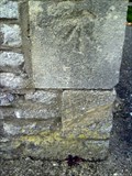
 view gallery view gallery E8 km E8 km
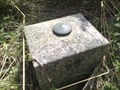
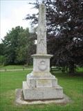
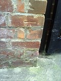
|   Buckland Fundamental Benchmark Buckland Fundamental Benchmark
in U.K. and Ireland Trigpoints A fundamental benchmark which can be found alongside the A420 near Buckland in the county of Oxfordshire. posted by:  T A G T A G location: South West England, United Kingdom date approved: 08/11/2009 last visited: 10/19/2020 |
 view gallery view gallery S12.4 km S12.4 km
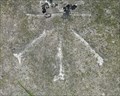
|  St George and the Dragon, Uffington, Oxfordshire, UK St George and the Dragon, Uffington, Oxfordshire, UK
in Weird Story Locations Local legend and folklore has it that this is the location that St George slayed the Dragon. posted by:  MTBpointer MTBpointer location: Southern Scotland, United Kingdom date approved: 02/14/2021 last visited: never |
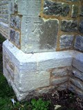
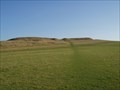 view gallery view galleryS12.9 km |  Uffington Castle Hillfort- Oxfordshire, UK Uffington Castle Hillfort- Oxfordshire, UK
in In Search of the Celts The earthwork remains of Uffington Castle Hillfort on the Ridgeway in South Oxfordshire. posted by: MTBpointer location: Southern England, United Kingdom date approved: 02/14/2021 last visited: never |
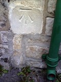
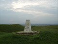 view gallery view galleryS12.9 km | White Horse Hill, near Woolstone, South Oxfordshire in U.K. and Ireland Trigpoints White Horse Hill Trigpoint in south Oxfordshire. posted by: theblack location: Southern England, United Kingdom date approved: 12/05/2007 last visited: 12/14/2014 |
 view gallery view gallery N13.5 km N13.5 km
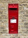
|  Victorian Wall Post Box - Widford, near Burford - Oxfordshire - UK Victorian Wall Post Box - Widford, near Burford - Oxfordshire - UK
in Victorian Post Boxes A Victorian wall post box in Widford near Burford in the county of Oxfordshire, UK. posted by: ntpayne location: West Midlands, United Kingdom date approved: 12/20/2019 last visited: never |
 view gallery view gallery NE13.8 km NE13.8 km
|  Ducklington Combined War Memorial - Oxon Ducklington Combined War Memorial - Oxon
in World War I Memorials and Monuments A Small Memorial in front of the Church and the Duckpond in this tiny Oxfordshire Village.
This memorial has 17 names for WW1 and 1 name for the Korean War and 2 for WW2.
posted by: Norfolk12 location: United Kingdom date approved: 07/20/2009 last visited: 09/06/2009 |
 view gallery view gallery SW14 km SW14 km
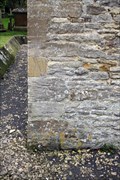
| Cut mark - Milestone, Beechcroft Road, Swindon, Wiltshire. in U.K. and Ireland Trigpoints This cut mark is located on a milestone. posted by: HitchinLookers location: South West England, United Kingdom date approved: 12/13/2011 last visited: never |
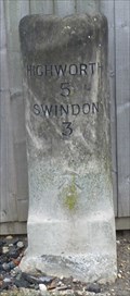
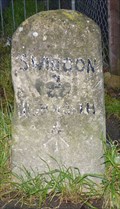 view gallery view gallerySW14 km |  Milestone - Beechcroft Road, Upper Stratton, Swindon, Wiltshire, UK. Milestone - Beechcroft Road, Upper Stratton, Swindon, Wiltshire, UK.
in Milestones I am not convinced that the mileages on this milestone are correct. So has it been re-positioned. posted by: HitchinLookers location: South West England, United Kingdom date approved: 11/16/2011 last visited: never |
 view gallery view galleryN14 km |  St. John the Baptist Cemetery - Burford, Oxfordshire, UK St. John the Baptist Cemetery - Burford, Oxfordshire, UK
in Worldwide Cemeteries Beautiful cemetery located on the grounds of St. John the Baptist Church. posted by: Trail Blaisers location: United Kingdom date approved: 02/18/2013 last visited: 07/06/2010 |
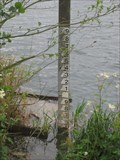 view gallery view galleryNE14.5 km |  Witney Lake - Oxon Witney Lake - Oxon
in River Gauges Witney Lake and Meadow river gauge, whilst walking around this lake we spotted a king fisher and a couple of crested grebe..
posted by: Norfolk12 location: United Kingdom date approved: 07/21/2009 last visited: 10/31/2020 |
 view gallery view gallerySW14.5 km | Cut mark - Milestone, Swindon Road, Stratton St Margarets, Swindon, Wiltshire. in U.K. and Ireland Trigpoints This cut mark is located on a milestone. But may not be in it's original position. posted by: HitchinLookers location: South West England, United Kingdom date approved: 12/12/2011 last visited: 01/22/2012 |
 view gallery view gallerySW14.5 km | Milestone - Swindon Road, Stratton St Margarets, Swindon, Wiltshire, Uk. in Milestones This is a confusing milestone. posted by: HitchinLookers location: South West England, United Kingdom date approved: 11/16/2011 last visited: 01/22/2012 |
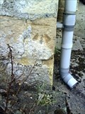 view gallery view galleryNE14.6 km | Cut Benchmark - #20 Ducklington Lane - Witney - UK in U.K. and Ireland Trigpoints Ordnance Survey cut mark benchmark described on the Bench Mark Database. posted by: Postells location: Southern England, United Kingdom date approved: 09/03/2011 last visited: never |
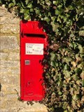 view gallery view galleryNE14.6 km | Victorian Wall Box - Fairfields - Hardwick - Witney - Oxfordshire - UK in Victorian Post Boxes A Victorian wall post box on Fairfields in Hardwick near Witney, Oxfordshire, UK. posted by: ntpayne location: West Midlands, United Kingdom date approved: 12/20/2019 last visited: never |
 view gallery view gallerySW14.6 km |  Moonrakers - Cricklade Road, Swindon, Wiltshire, UK. Moonrakers - Cricklade Road, Swindon, Wiltshire, UK.
in Pictorial Pub Signs This name is a reference to a legend suggesting that Wiltshire's smugglers were brighter than its excise men. posted by: HitchinLookers location: South West England, United Kingdom date approved: 12/23/2011 last visited: never |
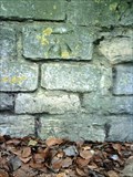 view gallery view galleryNE14.6 km | Cut Benchmark - Tower Hill - Witney - UK in U.K. and Ireland Trigpoints Ordnance Survey cut mark benchmark described on the Bench Mark Database. posted by: Postells location: Southern England, United Kingdom date approved: 09/03/2011 last visited: never |
 view gallery view galleryNE14.6 km | Cut Benchmark - #1 The Springs - Witney - UK in U.K. and Ireland Trigpoints Ordnance Survey cut mark benchmark described on the Bench Mark Database. posted by: Postells location: Southern England, United Kingdom date approved: 09/04/2011 last visited: never |
 view gallery view galleryNE14.8 km | Cut Benchmark - The Old Chapel - Witney - UK in U.K. and Ireland Trigpoints Ordnance Survey cut mark benchmark discussed on the Bench Mark Database. posted by: Postells location: Southern England, United Kingdom date approved: 09/03/2011 last visited: never |
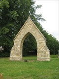 view gallery view galleryNE14.8 km |  Witney Arch - Oxon Witney Arch - Oxon
in Freestanding Arches a small arch near a converted church in the historic town of Witney posted by: Norfolk12 location: United Kingdom date approved: 07/24/2009 last visited: 11/07/2010 |
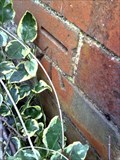 view gallery view galleryNE14.8 km | Cut Benchmark - #32 Tower Hill - Witney - UK in U.K. and Ireland Trigpoints Ordnance Survey cut mark benchmark described on the Bench Mark Database. posted by: Postells location: Southern England, United Kingdom date approved: 09/04/2011 last visited: never |
 view gallery view galleryNE14.8 km | Cut Benchmark - The Leys - Witney - UK in U.K. and Ireland Trigpoints Ordnance Survey cut mark benchmark described on the Bench Mark Database. posted by: Postells location: Southern England, United Kingdom date approved: 09/04/2011 last visited: never |
 view gallery view galleryNE14.8 km | Cut Benchmark - #18 The Crofts - Witney - UK in U.K. and Ireland Trigpoints Ordnance Survey cut mark benchmark described on the Bench Mark Database. posted by: Postells location: Southern England, United Kingdom date approved: 09/04/2011 last visited: never |
 view gallery view galleryNE14.8 km | Cut Benchmark - #122 Corn Street - Witney - UK in U.K. and Ireland Trigpoints Ordnance Survey cut mark benchmark described on the Bench Mark Database. posted by: Postells location: Southern England, United Kingdom date approved: 09/04/2011 last visited: never |
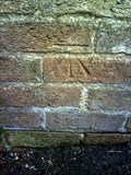 view gallery view galleryNE15 km | Cut Benchmark - #103 Burford Road - Witney - UK in U.K. and Ireland Trigpoints Ordnanace Survey cut mark benchmark described on the Bench Mark Database. posted by: Postells location: Southern England, United Kingdom date approved: 09/04/2011 last visited: never |
 view gallery view galleryNE15 km | Cut Benchmark - St Marys Church - Witney - UK in U.K. and Ireland Trigpoints Ordnance Survey cut mark benchmark described on the Bench Mark Database. posted by: Postells location: Southern England, United Kingdom date approved: 09/04/2011 last visited: never |
|