 view gallery view gallery N1.1 km N1.1 km
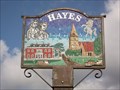
|   Pictorial Village Sign - Hayes Street/West Common Road, Hayes, Bromley, UK Pictorial Village Sign - Hayes Street/West Common Road, Hayes, Bromley, UK
in Pictorial Village Signs This flower bed and village sign is on the junction of Hayes Street and West Common Road. posted by:  jackhharveyjack jackhharveyjack location: London, United Kingdom date approved: 06/11/2012 last visited: 02/07/2015 |
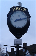 view gallery view galleryN1.1 km |  Hayes Diamond Jubilee Clock Hayes Diamond Jubilee Clock
in Town Clocks To commemorate the Queen's Diamond Jubilee the residents of Hayes, Bromley, Kent have funded a new Diamond Jubilee Clock which replaced the original 1977 Silver Jubilee Clock. posted by: back_ache location: London, United Kingdom date approved: 02/18/2015 last visited: 03/17/2015 |
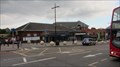
 view gallery view galleryN1.1 km |  Hayes Station - Station Approach, Hayes, London, UK Hayes Station - Station Approach, Hayes, London, UK
in Wikipedia Entries Hayes railway station serves Southeastern rail services on the line from London to Kent. The station, which is a terminus, is on the north west side of Station Approach in Hayes. posted by: Master Mariner location: London, United Kingdom date approved: 08/31/2015 last visited: never |
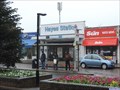 view gallery view galleryN1.1 km |  Hayes Station - Station Approach, Hayes, London, UK Hayes Station - Station Approach, Hayes, London, UK
in Train Stations/Depots Hayes railway station serves Southeastern rail services on the line from London to Kent. The station, which is a terminus, is on the north west side of Station Approach in Hayes. posted by: Master Mariner location: London, United Kingdom date approved: 08/31/2015 last visited: 01/26/2023 |
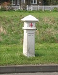 view gallery view gallery S3.4 km S3.4 km
|  186, Leaves Green 186, Leaves Green
in London Coal Tax Posts Beside the on the Green at Leaves Green on the W side of the A233 posted by: Team Sieni location: South East England, United Kingdom date approved: 04/01/2007 last visited: 09/28/2013 |
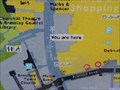
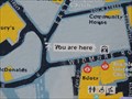
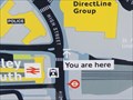 view gallery view galleryN3.7 km |  You Are Here - High Street, Bromley, London, UK You Are Here - High Street, Bromley, London, UK
in 'You Are Here' Maps This "you are here" map is on the west side of Bromley High Street opposite Bromley South railway station and Bromley Police Station. posted by: Master Mariner location: London, United Kingdom date approved: 07/05/2015 last visited: never |
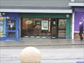 view gallery view galleryN3.7 km |  Subway - High Street, Bromley, London, UK Subway - High Street, Bromley, London, UK
in Subway Restaurants This Subway restaurant is on the west side of Bromley High Street opposite Bromley South railway station in south east London. posted by: Master Mariner location: London, United Kingdom date approved: 07/05/2015 last visited: never |
 view gallery view galleryN3.7 km | Bromley (South) Station - Unided Kingdom in Train Stations/Depots Bromley South railway station is a major station on the Chatham Main Line in Greater London within the London Borough of Bromley. posted by:  superstein superstein location: London, United Kingdom date approved: 06/15/2015 last visited: 07/24/2021 |
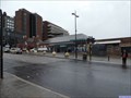 view gallery view galleryN3.7 km | Bromley South Station - High Street, Bromley, London, UK. in Wikipedia Entries Bromley South railway station is located on the east side of High Street in Bromley. The station serves Southeastern and Thameslink train servcies. posted by: Master Mariner location: London, United Kingdom date approved: 07/05/2015 last visited: never |
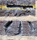 view gallery view galleryN3.7 km |  Cut Bench Mark - Elmfield Road, Bromley, London, UK Cut Bench Mark - Elmfield Road, Bromley, London, UK
in U.K. and Ireland Trigpoints This mark is cut into the brickwork of Bromley South railway station on the south side of Elmfield Road. The mark is at the north west corner of the station on the building's north face. posted by: Master Mariner location: London, United Kingdom date approved: 07/09/2015 last visited: never |
 view gallery view galleryN3.7 km | Cut Bench Mark - Elmfield Road, Bromley, London, UK. in U.K. and Ireland Trigpoints This mark is cut into a brick gate post on the east side of Elmfield Road. The mark is cut into the northern gate post. posted by: Master Mariner location: London, United Kingdom date approved: 07/09/2015 last visited: never |
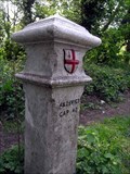 view gallery view galleryS3.9 km | 183, New Addington in London Coal Tax Posts W Side of King Henry's Drive. Between junctions with Fairchildes Ave to the N and Skidhill La to the South. "4 & 25 VICT CAP 42" posted by: Team Sieni location: London, United Kingdom date approved: 04/28/2007 last visited: 09/28/2013 |
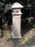 view gallery view galleryS4 km | 185, New Addington in London Coal Tax Posts On N side of Sheepbarn Lane, to the E of the junction with Skidhill La/Layhams Rd. "24 VICT" posted by: Team Sieni location: South East England, United Kingdom date approved: 04/28/2007 last visited: 09/28/2013 |
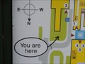
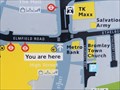 view gallery view galleryN4 km | You Are Here - High Street, Bromley, London, UK in 'You Are Here' Maps This "you are here" map is on the north east side of Bromley High Street at the junction with Elmfield Road at the southern end of the pedestrianised area. posted by: Master Mariner location: London, United Kingdom date approved: 07/05/2015 last visited: never |
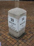 view gallery view galleryN4 km |  Bromley High Street Milestone - Bromley, London, UK Bromley High Street Milestone - Bromley, London, UK
in Milestones This milestone is in the pedestrianised are of Bromley High Street. It is on the south west side close to the junction with Ethelbert Road. posted by: Master Mariner location: London, United Kingdom date approved: 07/06/2015 last visited: 07/27/2021 |
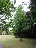 view gallery view galleryN4 km |  Bromley (UK) and Neuwied (Germany) - Bromley Civic Centre, Bromley, London, UK. Bromley (UK) and Neuwied (Germany) - Bromley Civic Centre, Bromley, London, UK.
in Sister City Monuments This tree was planted to commemorate the twinning of Bromley (UK) and Neuwied (Germany) on 16th October 1987. The tree is towards the southern boundary of Bromley Civic Centre's grounds. posted by: Master Mariner location: London, United Kingdom date approved: 07/10/2015 last visited: never |
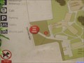 view gallery view galleryN4 km | You Are Here - Rafford Way, Bromley, London, UK. in 'You Are Here' Maps This "you are here" map is at the Rafford Way entrance to the Bromley Civic Centre and Bromley Palace Park. posted by: Master Mariner location: London, United Kingdom date approved: 07/08/2015 last visited: never |
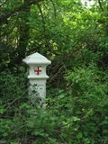 view gallery view galleryS4 km | 184, New Addington in London Coal Tax Posts In the hedge, W side of Skidhill Lane. "4 & 25 VICT CAP 42" posted by: Team Sieni location: South East England, United Kingdom date approved: 04/28/2007 last visited: 09/28/2013 |
 view gallery view galleryN4.2 km | You Are Here - High Street, Bromley, London, UK in 'You Are Here' Maps This "you are here" map is in the centre of the pedestrianised part of Bromley High Street close to the entrance to the Churchill Theatre and Library Gardens/Church House Gardens. posted by: Master Mariner location: London, United Kingdom date approved: 07/06/2015 last visited: never |
 view gallery view galleryN4.2 km | You Are Here - Rochester Avenue, Bromley, London, UK in 'You Are Here' Maps This "you are here" map is at the Rochester Avenue entrance to Bromley Civic Centre. posted by: Master Mariner location: London, United Kingdom date approved: 07/12/2015 last visited: never |
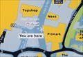 view gallery view galleryN4.3 km | You Are Here - High Street, Bromley, London, UK in 'You Are Here' Maps This "you are here" map is towards the north end of the pedestrianised part of Bromley High Street where it meets the pedestrianised part of Market Square. posted by: Master Mariner location: London, United Kingdom date approved: 07/06/2015 last visited: never |
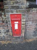 view gallery view galleryN4.3 km |  Victorian Post Box - Church Road, Bromley, London, UK Victorian Post Box - Church Road, Bromley, London, UK
in Victorian Post Boxes This Victorian post box is set into a wall that runs around Bromley parish church. It is on the south east side of Church Road near the north west corner of the church. posted by: Master Mariner location: London, United Kingdom date approved: 07/06/2015 last visited: never |
 view gallery view galleryN4.3 km | You Are Here - East Street, Bromley, London, UK. in 'You Are Here' Maps This "you are here" map is on the south east side of East Street at the junction with West Street in Bromley in south London. posted by: Master Mariner location: London, United Kingdom date approved: 07/06/2015 last visited: never |
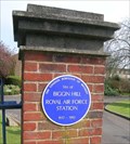 view gallery view galleryS4.3 km |  Biggin Hill RAF Station Biggin Hill RAF Station
in Blue Plaques Biggin Hill was an important RAF station during the Battle of Britain. posted by: Team Sieni location: South East England, United Kingdom date approved: 04/01/2007 last visited: 09/28/2013 |
 view gallery view galleryS4.3 km |  Biggin Hill RAF Station Biggin Hill RAF Station
in Static Aircraft Displays Replica Spitfire and Hurricane act as gate guardians as St George's RAF Chapel, Biggin Hill.
Biggin Hill was an important Royal Air Force base during the Battle of Britain, in summer 1940. It is now a commercial airport. posted by: Team Sieni location: South East England, United Kingdom date approved: 04/01/2007 last visited: 09/28/2013 |
|