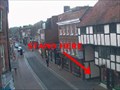
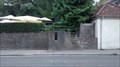
 view gallery view gallery W1.1 km W1.1 km
|   Godalming High Street from the Pepperpot Godalming High Street from the Pepperpot
in Web Cameras One of two web cams that are placed in the old market building on Godalming High Street. This one looks along the street to the East. posted by:  MichaelvanK MichaelvanK location: South East England, United Kingdom date approved: 11/03/2009 last visited: 08/13/2022 |
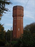 view gallery view gallery SE1.1 km SE1.1 km
|  Munstead Water Tower, near Godalming, Surrey Munstead Water Tower, near Godalming, Surrey
in Water Towers Red brick-built water tower on Munstead Heath, near Godalming in Surrey. posted by: Four Cool Dudes location: South East England, United Kingdom date approved: 04/29/2012 last visited: 04/27/2014 |
 view gallery view gallery N2.4 km N2.4 km
|  Boris Karloff - Godalming, Sussex, England Boris Karloff - Godalming, Sussex, England
in Grave of a Famous Person Final resting place of horror movie icon Boris Karloff, best known for his role as Frankenstein’s monster in the 1931 feature. posted by:  hykesj hykesj location: South East England, United Kingdom date approved: 10/08/2022 last visited: never |
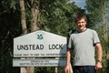 view gallery view gallery NE2.7 km NE2.7 km
|  Unstead Lock Unstead Lock
in Waterway Locks, Planes and Lifts Unstead Lock located on the River Wey (Godalming Navigation) in Surrey posted by: halthornhill location: South East England, United Kingdom date approved: 06/19/2011 last visited: 04/27/2014 |
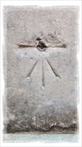
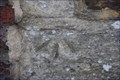
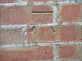 view gallery view galleryNE3.1 km |  Cut Bench Mark - Horsham Road, Bramley, Surrey Cut Bench Mark - Horsham Road, Bramley, Surrey
in U.K. and Ireland Trigpoints Cut bench mark on brick-built letter box in Bramley, Surrey. posted by: Four Cool Dudes location: South East England, United Kingdom date approved: 10/24/2011 last visited: 04/27/2014 |
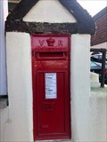
 view gallery view gallery SW3.4 km SW3.4 km
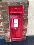
|  Victorian Wall Post Box - Milford, Surrey, UK Victorian Wall Post Box - Milford, Surrey, UK
in Victorian Post Boxes A Victorian wall mounted post box at Milford station in Surrey posted by: ntpayne location: Southern England, United Kingdom date approved: 06/12/2018 last visited: never |
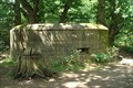 view gallery view galleryNE3.9 km |  Pillbox S0010079 - Shalford Rail Junction Pillbox S0010079 - Shalford Rail Junction
in World War II Sites This World War II Pillbox is located on National Trust land near the Shalford Rail Junction in Surrey. It can be seen clearly from the River Wey Godalming Navigation posted by: halthornhill location: South East England, United Kingdom date approved: 06/14/2011 last visited: 04/26/2014 |
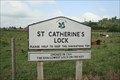 view gallery view galleryNE4.3 km | St. Catherine's Lock in Waterway Locks, Planes and Lifts St.Catherine's Lock is situated on the River Wey (Godalming Navigation) posted by: halthornhill location: South East England, United Kingdom date approved: 06/19/2011 last visited: 04/27/2014 |
 view gallery view galleryNE4.5 km | 'Stopline' - A281 Shalford Road, Shalford, Surrey, GU 4 8BU in World War II Sites Remnants of a WWII GHQ 'stopline' roadblock alongside the Shalford Road, immediately south of the Seahorse Public House. posted by: MeerRescue location: South East England, United Kingdom date approved: 08/24/2015 last visited: 08/16/2017 |
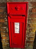
 view gallery view gallery E4.5 km E4.5 km
| Victorian Wall Post Box - Stonards Lane - Shamley Green - Surrey - UK in Victorian Post Boxes A Victorian postbox in Shamley Green, Surrey, UK posted by: ntpayne location: Southern England, United Kingdom date approved: 12/27/2019 last visited: never |
 view gallery view galleryNE4.7 km | Cut Bench Mark and Rivet - St Mary The Virgin Church, Shalford, Surrey in U.K. and Ireland Trigpoints A Cut Bench Mark and Rivet sited on the tower corner, close to the west door of St Mary The Virgin Church in Shalford, Surrey, GU4 8AE posted by: MeerRescue location: South East England, United Kingdom date approved: 08/21/2015 last visited: never |
 view gallery view gallerySW5 km | Victorian Wall Post Box - Cramhurst, near Godalming, Surrey, UK in Victorian Post Boxes A Victorian Wall Post Box in Cramhurst near Godalming in Surrey, UK posted by: ntpayne location: Southern England, United Kingdom date approved: 12/30/2018 last visited: never |
 view gallery view galleryN5.8 km | Millmead Lock - River Wey in Waterway Locks, Planes and Lifts Millmead lock is located in Guildford on the River Wey Godalming Navigation posted by: halthornhill location: South East England, United Kingdom date approved: 06/19/2011 last visited: 06/20/2017 |
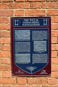 view gallery view galleryN5.8 km |  The Wey and Godalming Navigations - Guildford, Surrey, UK The Wey and Godalming Navigations - Guildford, Surrey, UK
in UK Historical Markers This blue historical plaque, close to Millmeads Lock, tells the story of a man's vision to connect the town of Guildford with the River Thames. posted by: Master Mariner location: South East England, United Kingdom date approved: 01/07/2018 last visited: never |
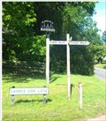 view gallery view galleryNE6 km |  This Way, That Way, Somewhere Else This Way, That Way, Somewhere Else
in Unusual Signs An unusual signpost in Blackheath, Surrey reading THIS WAY, THAT WAY and SOMEWHERE ELSE posted by: Team Sieni location: South East England, United Kingdom date approved: 06/19/2015 last visited: 08/31/2021 |
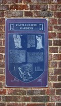 view gallery view galleryN6 km | Castle Cliffe Gardens - Castle Hill, Guildford, UK in UK Historical Markers This metal plaque is attached to a boundary wall on the south side of Castle Hill adjacent to steps leading into the gardens. posted by: Master Mariner location: South East England, United Kingdom date approved: 01/08/2018 last visited: never |
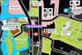 view gallery view galleryN6 km |  You Are Here - Millbrook, Guildford, UK You Are Here - Millbrook, Guildford, UK
in 'You Are Here' Maps This "you are here" map is located on the south west side of Millbrook, close to the Yvonne Arnaud Theatre, in Guildford. posted by: Master Mariner location: South East England, United Kingdom date approved: 01/06/2018 last visited: never |
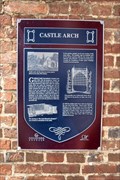 view gallery view galleryN6 km | Castle Arch - Castle Hill, Guildford, UK in UK Historical Markers Castle ARch is located at the west end of Castle Hill at the junction with Quarry Street. The plaque is attached to a building on the north side of Castle Hill just within the arch. posted by: Master Mariner location: South East England, United Kingdom date approved: 01/08/2018 last visited: never |
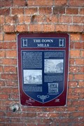 view gallery view galleryN6 km | The Town Mills - Millbrook, Guildford, UK in UK Historical Markers This plaque is on the south west side of Millbrook in Guildford. The plaque is attached to the north west face of Mill Studios, a former mill building dating from 1896 posted by: Master Mariner location: South East England, United Kingdom date approved: 01/07/2018 last visited: never |
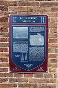 view gallery view galleryN6 km | Guildford Museum - Quarry Street, Guildford, UK in UK Historical Markers The plaque is attached to the Guildford Museum, dating from c1630, located on the north east side of Quarry Street close to Guildford town centre and Guildford castle. posted by: Master Mariner location: South East England, United Kingdom date approved: 01/07/2018 last visited: never |
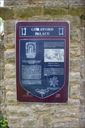 view gallery view galleryN6 km | Guildford Palace - Castle Grounds, Guildford, UK in UK Historical Markers This plaque is attached to a stone entrance arch to Guildford Castle Grounds. The arch is on the north side of Castle Hill, south west of the castle. posted by: Master Mariner location: South East England, United Kingdom date approved: 01/08/2018 last visited: never |
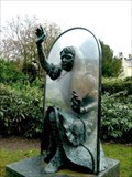 view gallery view galleryN6 km |  Alice Through the Looking Glass - Guildford, Surrey, UK Alice Through the Looking Glass - Guildford, Surrey, UK
in Famous Fictional Figures Bronze sculpture of Alice Through The Looking Glass in the gardens of Guildford Castle posted by: ashberry location: South East England, United Kingdom date approved: 08/24/2021 last visited: 06/17/2022 |
 view gallery view galleryN6 km | Cut Bench Mark - St Nicholas Church, Guildford, UK in U.K. and Ireland Trigpoints This mark is cut into the stonework of St Nicholas Church. The church is located on the south east side of the High Street just to the west of the Town Bridge. The mark is on the north west face of the church close to its north corner. posted by: Master Mariner location: South East England, United Kingdom date approved: 07/15/2017 last visited: never |
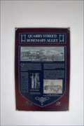 view gallery view galleryN6 km | Quarry Street/Rosemary Alley - Guildford, Surrey, UK in UK Historical Markers The plaque is attached to a building on the north east side of Quarry Street at the junction with Castle Street, close to Guildford town centre, St Mary's Church and the Castle. Rosemary Alley is on the opposite side of Quarry Street to the plaque. posted by: Master Mariner location: South East England, United Kingdom date approved: 01/07/2018 last visited: never |
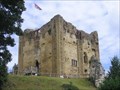 view gallery view galleryN6 km |  Guildford Castle - Guildford, Surrey, UK Guildford Castle - Guildford, Surrey, UK
in Wikipedia Entries Guildford Castle is in Guildford, Surrey, England. It is thought to have been built by William the Conqueror, or one of his barons, shortly after the 1066 invasion of England. posted by: ashberry location: South East England, United Kingdom date approved: 08/03/2021 last visited: 07/05/2014 |
|