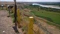
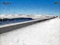
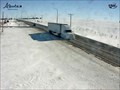
 view gallery view gallery E22.4 km E22.4 km
|   Checkerboard Hill Lookout Checkerboard Hill Lookout
in Saskatchewan Historical Markers Located Northwest of Leader. Multiple description boards that describe many area subjects including history. posted by:  Altima Voyageur Altima Voyageur location: Saskatchewan, Canada date approved: 10/19/2017 last visited: never |
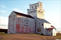
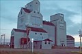
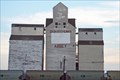
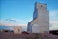 view gallery view galleryE33.3 km |  Saskatchewan Wheat Pool Elevator - Leader, Saskatchewan Saskatchewan Wheat Pool Elevator - Leader, Saskatchewan
in Grain Elevators Leader can be found about 160 km. northwest of Swift Current, Saskatchewan, on Highways 32 and 21. posted by:  T0SHEA T0SHEA location: Saskatchewan, Canada date approved: 02/01/2013 last visited: 02/28/2014 |
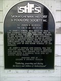
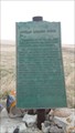
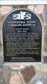 view gallery view galleryE33.8 km | Smith Barn in Saskatchewan Historical Markers This scaled down replica of the actual barn sits near the town of Leader tourist booth located on Hwy 21 and the corner of 5 Avenue East. The actual barn site is located km's North West of Leader. posted by: Altima Voyageur location: Saskatchewan, Canada date approved: 09/16/2017 last visited: never |
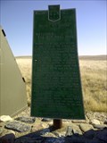 view gallery view gallery NE38.9 km NE38.9 km
| Battleford/Red Deer Forks Trail in Saskatchewan Historical Markers One of many trails that cross the prairies. The Battleford-Red Deer Forks Trail lies near. posted by: Altima Voyageur location: Saskatchewan, Canada date approved: 05/08/2012 last visited: never |
 view gallery view gallery SE39.8 km SE39.8 km
| St John's School, NE 1/4 4-21-36 W3M in Saskatchewan Historical Markers Just along the side of the road. posted by: Altima Voyageur location: Saskatchewan, Canada date approved: 06/19/2013 last visited: never |
 view gallery view galleryE43.1 km | Paterson Elevator - Prelate Saskatchewan in Grain Elevators Where on earth is Prelate? Well, it's around 9 km. west of Sceptre, which is 19 km west of Portreeve, which is 47 km. northwest of Cabri, which is another 63 km. or so up Highway 32 from Speedy Crick, Saskatchewan. posted by: T0SHEA location: Saskatchewan, Canada date approved: 02/05/2013 last visited: 02/25/2014 |
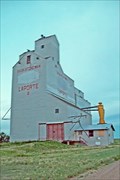 view gallery view galleryNE45.1 km | Saskatchewan Wheat Pool B - Laporte, Saskatchewan in Grain Elevators Along Highway 44, the tiny hamlet of Laporte is 39 short km. east of the Alberta border. posted by: T0SHEA location: Saskatchewan, Canada date approved: 02/07/2013 last visited: 02/22/2014 |
 view gallery view gallerySE46.7 km | Dedication to Pioneer Families and Oblate Fathers in Saskatchewan Historical Markers Located in hamlet of Liebenthal. Junctions of Hwy 21 and Hwy 321. posted by: Altima Voyageur location: Saskatchewan, Canada date approved: 06/26/2013 last visited: 06/30/2014 |
 view gallery view gallery NW52.3 km NW52.3 km
|  Sibbald Highway Web Camera - Sibbald, Alberta Sibbald Highway Web Camera - Sibbald, Alberta
in Web Cameras This Alberta Highways Webcam is mounted on a steel tower along Highway 9 about midway between Oyen and Sibbald. posted by: T0SHEA location: Alberta, Canada date approved: 03/03/2014 last visited: 08/04/2014 |
 view gallery view galleryNE52.3 km | Eatonia's Catalogue House in Saskatchewan Historical Markers Eatons Catalogue House in Eatonia, near caboose. posted by: Altima Voyageur location: Saskatchewan, Canada date approved: 06/19/2013 last visited: never |
 view gallery view galleryNE52.6 km | Saskatchewan Wheat Pool Elevator - Eatonia, Saskatchewan in Grain Elevators Stretching for over 2,000 feet along the north side of Highways 21 & 44, Eatonia presents a somewhat different posture, with an elevator on one side of the road and an airport on the other. posted by: T0SHEA location: Saskatchewan, Canada date approved: 02/07/2013 last visited: 02/22/2014 |
 view gallery view galleryNE63.7 km | Buffalo Rubbing Stone (Near Flaxcombe) in Saskatchewan Historical Markers Located near the town Flaxcombe on Hwy 7. posted by: Altima Voyageur location: Saskatchewan, Canada date approved: 05/27/2017 last visited: never |
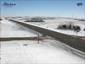 view gallery view galleryNW67.4 km | Oyen Highway Web Camera - Oyen, Alberta in Web Cameras This Alberta Highways Webcam is mounted on a steel tower along Highway 9 about midway between Cereal and Oyen. posted by: T0SHEA location: Alberta, Canada date approved: 03/03/2014 last visited: 07/28/2014 |
 view gallery view gallerySE79.2 km |  Conestoga Wagon - Moose Jaw, Saskatchewan Conestoga Wagon - Moose Jaw, Saskatchewan
in Covered Wagons a covered wagon on the property of a cattle ranch located on the TransCanada Highway 2, south of the town of Moose Jaw, Saskatchewan, Canada posted by: oiseau_ca location: Saskatchewan, Canada date approved: 03/06/2015 last visited: never |
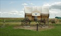 view gallery view gallerySE79.2 km |  Farm Wagon - Moose Jaw, Saskatchewan Farm Wagon - Moose Jaw, Saskatchewan
in Old Agricultural Equipment an old farm wagon on the property of a cattle ranch located on the TransCanada Highway 2, south of the town of Moose Jaw, Saskatchewan, Canada posted by: oiseau_ca location: Saskatchewan, Canada date approved: 12/05/2014 last visited: never |
 view gallery view galleryE80.6 km | Two Seasons of the Chokecherry in Saskatchewan Historical Markers Located in town of Lancer. posted by: Altima Voyageur location: Saskatchewan, Canada date approved: 10/05/2017 last visited: never |
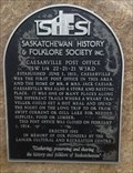 view gallery view galleryE83.8 km | Caeserville Post Office in Saskatchewan Historical Markers Located east of Lancer Saskatchewan on posted by: Altima Voyageur location: Saskatchewan, Canada date approved: 09/18/2017 last visited: never |
 view gallery view galleryE90.8 km | Saskatchewan Wheat Pool B - Abbey, Saskatchewan in Grain Elevators Here's an interesting statistic: In 2006, when the little hamlet of Abbey had a population of 130, it ranked 4,287th in population in Canada. Not much has changed since then. posted by: T0SHEA location: Saskatchewan, Canada date approved: 09/12/2012 last visited: 01/24/2014 |
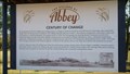 view gallery view galleryE91.2 km | Abbey in Saskatchewan Historical Markers Located on Railway Avenue and Wayne Street. posted by: Altima Voyageur location: Saskatchewan, Canada date approved: 09/18/2017 last visited: never |
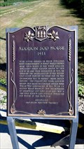 view gallery view galleryNE101.2 km | Addison Sod House (Provincial Site) in Saskatchewan Historical Markers Both and provincial and national site the Addison Sod House has lasted over a hundred years. Located north of Kindersley on Hwy 21, then East on Gleneath Road, 10.6 kilometers. posted by: Altima Voyageur location: Saskatchewan, Canada date approved: 09/16/2017 last visited: never |
 view gallery view galleryNE101.2 km | Addison Sod House (National Site) in Saskatchewan Historical Markers Both a Provincial and National Site Addison Sod House historic site is a house that was built over a hundred years ago and is still a habitable home. Located north of Kindersley on Hwy 21, then East on Gleneath Road, 10.6 kilometers. posted by: Altima Voyageur location: Saskatchewan, Canada date approved: 09/16/2017 last visited: never |
 view gallery view galleryNE101.2 km |  CNHS Addison House CNHS Addison House
in Canadian National Historic Sites National Historic Site Addison Sod House, is a house that was built over a hundred years ago and is still a habitable home. Located north of Kindersley on Hwy 21, then East on Gleneath Road, 10.6 kilometers. posted by: Altima Voyageur location: Saskatchewan, Canada date approved: 09/20/2017 last visited: never |
 view gallery view galleryNW105.1 km | Youngstown Highway Web Camera - Youngstown, Alberta in Web Cameras This Alberta Highways Webcam is mounted on a steel tower along Highway 9 just west of Youngstown. posted by: T0SHEA location: Alberta, Canada date approved: 03/03/2014 last visited: 07/28/2014 |
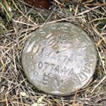 view gallery view gallery SW111 km SW111 km
|  GSD 68A174 - Bowell (Alberta) GSD 68A174 - Bowell (Alberta)
in Canadian Benchmarks Benchmark 68A174 between Redcliff and Suffield, Alberta posted by: dubious20 location: Alberta, Canada date approved: 05/28/2006 last visited: 09/27/2006 |
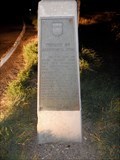 view gallery view gallery S111.2 km S111.2 km
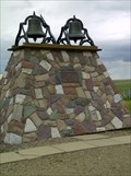
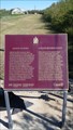
|  District of Assiniboia, 1882 - Walsh, AB District of Assiniboia, 1882 - Walsh, AB
in Alberta Heritage Markers Heritage Marker recounting the division of the District of Assiniboia in 1905. posted by: jiggs11 location: Alberta, Canada date approved: 10/22/2020 last visited: 07/24/2019 |
|