 view gallery view gallery SE3.5 km SE3.5 km
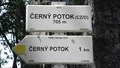
|   705m - Cerny Potok, Krystofovy Hamry, Czech Republic 705m - Cerny Potok, Krystofovy Hamry, Czech Republic
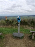
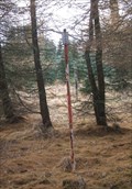
in Elevation Signs Elevation sign (705 m) in Krystofovy Hamry posted by:  castorka castorka location: Ústecký kraj, Czechia date approved: 07/15/2018 last visited: never |
 view gallery view gallery S7.7 km S7.7 km
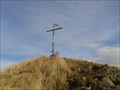
|  Velký Špicák, Klášterec nad Ohrí, Czech Republic Velký Špicák, Klášterec nad Ohrí, Czech Republic
in Mountain Summits CZ: Velký špicák, dominanta Prísecnické hornatiny
EN: Great Spitzberg, a dominant feature from Prísecnice posted by: bediss location: Ústecký kraj, Czechia date approved: 12/05/2012 last visited: 05/14/2015 |
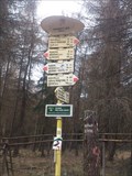 view gallery view gallerySE11.9 km |  Farsky les, Czech Republic Farsky les, Czech Republic
in Direction and Distance Arrows CZ: Rozcestník turistických tras na cervené a žluté turistické znacce Farský les. EN: Direction and Distance Arrows of tourist paths Farsky les. posted by: Petrs11 location: Ústecký kraj, Czechia date approved: 04/16/2016 last visited: 07/09/2016 |
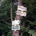
 view gallery view gallerySE11.9 km | 822 m - Farsky les, Czech Republic in Elevation Signs CZ: Rozcestník turistických tras na cervené a žluté turistické znacce Farský les. EN: Direction and Distance Arrows of tourist paths Farsky les. posted by: Petrs11 location: Ústecký kraj, Czechia date approved: 04/14/2016 last visited: 07/09/2016 |
 view gallery view gallerySE12.1 km |  Vetrná elektrárna Kryštofovy Hamry Vetrná elektrárna Kryštofovy Hamry
in Windmills CZ: Vetrné elektrárny podlíž Prísecnické prehrady v Krušných horách
EN: Wind power plant near Prisecnice dam in Ore mountains posted by: bediss location: Ústecký kraj, Czechia date approved: 11/19/2012 last visited: 03/02/2017 |
 view gallery view galleryS12.2 km |  TB 0515-6 Medenec, kaple P.Marie TB 0515-6 Medenec, kaple P.Marie
in Czech Geodetic Points Trigonometrický bod 20km západne od Chomutova posted by: pavlikVB location: Ústecký kraj, Czechia date approved: 07/14/2019 last visited: 06/21/2022 |
 view gallery view gallery E12.2 km E12.2 km
| Rozcestník turistických tras - Pohranicní (CZ/D), Czechia in Direction and Distance Arrows Rozcestník turistických tras Pohranicní (CZ/D) / Direction and Distance Arrows of tourist trails in Pohranicní (CZ/D) posted by: ashberry location: Ústecký kraj, Czechia date approved: 10/30/2019 last visited: never |
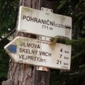 view gallery view galleryE12.2 km | 771m - POHRANICNÍ (CZ/D), Czechia in Elevation Signs CZ/ Výška uvedená na rozcestníku "771m - POHRANICNÍ (CZ/D)" EN/ Elevation Sign on crossroads "771m - POHRANICNÍ (CZ/D)" posted by: ashberry location: Ústecký kraj, Czechia date approved: 08/02/2019 last visited: never |
 view gallery view galleryE12.4 km | TB 0509-6 Jilmová v. in Czech Geodetic Points Trigonometrický bod TB 0509-6 Jilmová v. Bod je asi 25m západne od silnice Hora Svatého Šebestiána - státní hranice. posted by: ashberry location: Ústecký kraj, Czechia date approved: 08/14/2019 last visited: never |
![Image for TB 0520-5.0 (ETRS) [DOPNUL] Hájenský kopec](https://img.geocaching.com/waymarking/small/adfe3109-aa08-45dd-8760-695656ff7690.jpeg) view gallery view galleryS12.7 km | TB 0520-5.0 (ETRS) [DOPNUL] Hájenský kopec in Czech Geodetic Points Trigonometrický bod poblíž obce Háj. posted by: QuoX location: Ústecký kraj, Czechia date approved: 09/12/2023 last visited: never |
 view gallery view gallery SW13.2 km SW13.2 km
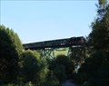
|  Hüttenbachtalviadukt - Oberwiesenthal, Sachsen, Germany Hüttenbachtalviadukt - Oberwiesenthal, Sachsen, Germany
in Railroad Bridges The bridge is used for a narrow-gauge railway *** ein Viadukt der Fichtelbergbahn posted by: dieSulzer location: Sachsen, Germany date approved: 10/02/2013 last visited: 09/19/2021 |
 view gallery view gallerySW13.2 km | Fichtelberg - höchster Berg der DDR in Mountain Summits Der Fichtelberg (1.214,6 m ü. HN) ist der höchste Berg Sachsens. posted by: ankay location: Sachsen, Germany date approved: 03/17/2008 last visited: 07/28/2019 |
 view gallery view gallerySW13.2 km |  Fichtelberg - Oberwiesental, Sachsen, GER Fichtelberg - Oberwiesental, Sachsen, GER
in Penny Smashers Penny Smasher with 2 designs ion the top of Fichtelberg (highest mountain of east germany) posted by: die_sonnenkoeppe location: Sachsen, Germany date approved: 05/26/2017 last visited: 08/02/2020 |
 view gallery view gallerySW13.2 km |  BINO - looking over Obersdorf to Keilberg BINO - looking over Obersdorf to Keilberg
in Coin-Op Binoculars binocular with view to Keilberg posted by: die_sonnenkoeppe location: Sachsen, Germany date approved: 05/22/2017 last visited: 07/28/2019 |
 view gallery view gallerySW13.2 km |  Friedensglocke-Fichtelberg, Sachsen, Germany Friedensglocke-Fichtelberg, Sachsen, Germany
in Love Padlocks E 012° 50° posted by: die_sonnenkoeppe location: Sachsen, Germany date approved: 05/22/2017 last visited: 07/28/2019 |
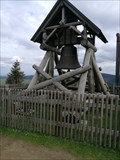 view gallery view gallerySW13.2 km |  Friedensglocke Fichtelberg, Sachsen, Germany Friedensglocke Fichtelberg, Sachsen, Germany
in Bells Die Glocke wurde zum 20 jährigen Jubiläum der deutschen Wiedervereinigung aufgestellt
The bell was put on the 20th anniversary of German reunification posted by: die_sonnenkoeppe location: Sachsen, Germany date approved: 05/22/2017 last visited: 08/02/2020 |
 view gallery view gallerySW13.2 km |  Mitteleuropäische Gratmessung- Station Fichtelberg Mitteleuropäische Gratmessung- Station Fichtelberg
in German Trigonometric Points Königlich-Sächsische Triangulationspunkt auf dem Fichtelberg posted by: die_sonnenkoeppe location: Sachsen, Germany date approved: 06/03/2017 last visited: 07/28/2019 |
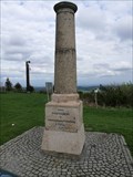 view gallery view gallerySW13.2 km |  Mitteleuropäische Gratmessung- Station Fichtelberg Mitteleuropäische Gratmessung- Station Fichtelberg
in Freestanding Columns Säule auf dem Fichtelberg posted by: die_sonnenkoeppe location: Sachsen, Germany date approved: 06/02/2017 last visited: 07/28/2019 |
 view gallery view gallerySW13.4 km |  Coat of Arms Kurort Oberwiesenthal, Germany Coat of Arms Kurort Oberwiesenthal, Germany
in Coats of Arms Coat of Arms Kurort Oberwiesenthal on Fichtelbergbahn station posted by: Petrs11 location: Sachsen, Germany date approved: 12/31/2013 last visited: 07/27/2020 |
 view gallery view gallerySW13.4 km |  Bahnhof Station Kurort Oberwiesenthal, Sachsen, Germany Bahnhof Station Kurort Oberwiesenthal, Sachsen, Germany
in Train Stations/Depots End station of Fichtelbergbahn - Cranzahl–Kurort Oberwiesenthal-Cranzahl. posted by: Petrs11 location: Sachsen, Germany date approved: 01/27/2014 last visited: 07/27/2020 |
 view gallery view gallerySW13.4 km |  Railway Station Kurort Oberwiesenthal, Sachsen, Germany Railway Station Kurort Oberwiesenthal, Sachsen, Germany
in Active Rail Locations Railway Station Kurort Oberwiesenthal, Sachsen posted by: Petrs11 location: Sachsen, Germany date approved: 01/24/2014 last visited: 07/27/2020 |
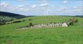 view gallery view galleryS13.4 km |  Hrbitov Loucná pod Klínovcem, Ustecky kraj, Czech Republic Hrbitov Loucná pod Klínovcem, Ustecky kraj, Czech Republic
in Worldwide Cemeteries the cemetery from Loucná and Háj, Czech Republic posted by: dieSulzer location: Ústecký kraj, Czechia date approved: 10/03/2013 last visited: 06/18/2018 |
 view gallery view galleryE13.5 km | TB 0508-5 V jednadvacítce in Czech Geodetic Points TB v modrinovem lese na vrcholu kopce, 840 m n.m. posted by: haggaeus location: Ústecký kraj, Czechia date approved: 11/18/2009 last visited: never |
 view gallery view galleryE13.8 km | TB 0509-10.1 Hora Sv.Šebestiána,kst. in Czech Geodetic Points Trigonometrický bod TB 0509-10.1 Hora Sv.Šebestiána,kst. Bod je námestí v Hore Svatého Šebestiána. Centrum prevedeno na ZB1 (kostel byl zboren). posted by: ashberry location: Ústecký kraj, Czechia date approved: 08/14/2019 last visited: never |
 view gallery view gallery NW13.8 km NW13.8 km
|  Gaststätte & Pension Waldschänke Geyer/ Saxony/Germany Gaststätte & Pension Waldschänke Geyer/ Saxony/Germany
in Pubs and Inns Die Gaststätte „Waldschänke Geyer“ befindet sich in einem Historischen Gebäude. posted by: Team-WS location: Sachsen, Germany date approved: 01/04/2023 last visited: 05/03/2023 |
|