 view gallery view gallery W0.6 km W0.6 km
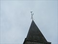
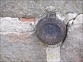
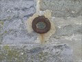
|   Benchmark Géodésique Eglise d'AIX Benchmark Géodésique Eglise d'AIX
in French Benchmarks Benchmark du Nord posted by:  geotrouvtou59 geotrouvtou59 location: Hauts-de-France, France date approved: 04/27/2014 last visited: 04/25/2014 |
 view gallery view galleryW0.6 km | Benchmark Eglise d'AIX in French Benchmarks Benchmarck du Nord posted by: geotrouvtou59 location: Hauts-de-France, France date approved: 04/27/2014 last visited: 04/27/2014 |
 view gallery view gallery S1.6 km S1.6 km
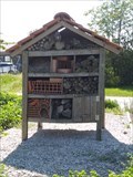
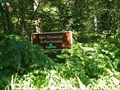
|  Hôtel à Insectes - Landas, France Hôtel à Insectes - Landas, France
in Insect Hotels [EN] Insect hotel Landas.
[FR] Hôtel à insectes Landas. posted by: geotrouvtou59 location: Hauts-de-France, France date approved: 05/17/2020 last visited: 05/17/2020 |
 view gallery view gallery SE1.8 km SE1.8 km
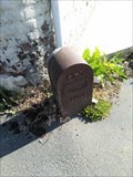
|  Borne Kilometrique - Landas, France Borne Kilometrique - Landas, France
in Milestones EN - Landas common kilometer marker.
FR - Borne kilométrique commune de Landas. posted by: geotrouvtou59 location: Hauts-de-France, France date approved: 05/25/2020 last visited: 05/25/2020 |
 view gallery view galleryS1.8 km |  Boite à livres - Landas, France Boite à livres - Landas, France
in Free Community Book Exchanges [EN] A box reading where each of us the opportunity to drop off a book. [FR] Une boîte de lecture où chacun de nous a la possibilité de déposer un livre. posted by: geotrouvtou59 location: Hauts-de-France, France date approved: 05/16/2020 last visited: 05/16/2020 |
 view gallery view galleryS1.8 km | Benchmark Eglise de LANDAS in French Benchmarks Benchmarck du Nord posted by: geotrouvtou59 location: Hauts-de-France, France date approved: 04/27/2014 last visited: 04/27/2014 |
 view gallery view galleryS1.8 km | Benchmarck Mairie de LANDAS in French Benchmarks Benchmarck du Nord posted by: geotrouvtou59 location: Hauts-de-France, France date approved: 04/27/2014 last visited: 04/27/2014 |
 view gallery view galleryS1.8 km | Benchmark Géodésique Eglise de LANDAS in French Benchmarks Benchmarck de Nord posted by: geotrouvtou59 location: Hauts-de-France, France date approved: 04/27/2014 last visited: 04/27/2014 |
 view gallery view gallerySE3.1 km | Benchmarck Géodésique Eglise de SAMEON in French Benchmarks Benchmarck du Nord posted by: geotrouvtou59 location: Hauts-de-France, France date approved: 04/27/2014 last visited: 04/27/2014 |
 view gallery view gallerySE3.1 km | Benchmarck Eglise de SAMEON in French Benchmarks Bencmarck du Nord posted by: geotrouvtou59 location: Hauts-de-France, France date approved: 04/27/2014 last visited: 04/27/2014 |
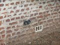
 view gallery view galleryS3.4 km | Benchmark Repère de nivellement BD - 215 Rue Albert Ricquier à BEUVRY-LA-FORET in French Benchmarks Benchmark du Nord
A 230 M AU NORD-OUEST DU CARREFOUR AVEC LA D.126, AU NO 724 ET 726 RUE ALBERT RICQUIER posted by: geotrouvtou59 location: Hauts-de-France, France date approved: 03/18/2017 last visited: 03/18/2017 |
 view gallery view galleryS3.4 km | Benchmark Repère de nivellement BD - 216 Rue Albert Ricquier à BEUVRY-LA-FORET in French Benchmarks Benchmark du Nord
A 230 M AU NORD-OUEST DU CARREFOUR AVEC LA D.126, AU NO 724 ET 726 RUE ALBERT RICQUIER posted by: geotrouvtou59 location: Hauts-de-France, France date approved: 03/18/2017 last visited: 03/18/2017 |
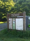
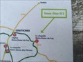
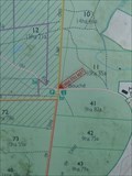 view gallery view galleryS6.1 km |  Vous Etes Ici : Forêt domaniale de Marchiennes - Marchiennes, France Vous Etes Ici : Forêt domaniale de Marchiennes - Marchiennes, France
in 'You Are Here' Maps FR - Propriété de l'abbaye de Marchiennes jusqu'en 1793 où elle devient propriété de l'État.
EN - Property of Marchiennes Abbey until 1793 when it became state property. posted by: geotrouvtou59 location: Hauts-de-France, France date approved: 07/31/2020 last visited: 07/28/2020 |
 view gallery view galleryS6.4 km |  Forêt domaniale de Marchiennes - Marchiennes, France Forêt domaniale de Marchiennes - Marchiennes, France
in Wikipedia Entries FR - Propriété de l'abbaye de Marchiennes jusqu'en 1793 où elle devient propriété de l'État.
EN - Property of Marchiennes Abbey until 1793 when it became state property. posted by: geotrouvtou59 location: Hauts-de-France, France date approved: 07/30/2020 last visited: 07/28/2020 |
 view gallery view galleryS6.4 km |  Forêt domaniale de Marchiennes - Marchiennes, France Forêt domaniale de Marchiennes - Marchiennes, France
in Public Access Lands FR - Propriété de l'abbaye de Marchiennes jusqu'en 1793 où elle devient propriété de l'État.
EN - Property of Marchiennes Abbey until 1793 when it became state property. posted by: geotrouvtou59 location: Hauts-de-France, France date approved: 08/23/2020 last visited: 08/23/2020 |
 view gallery view gallery SW7.2 km SW7.2 km
| Vous Etes Ici : La chapelle Notre-Dame-de-Foy - Coutiches, France in 'You Are Here' Maps EN - Coutiches chapels circuit
FR - Circuit des chapelles Coutiches posted by: geotrouvtou59 location: Hauts-de-France, France date approved: 05/24/2020 last visited: 05/21/2020 |
 view gallery view gallerySW7.2 km | ") Le Circuit des Chapelles - La chapelle Notre-Dame-de-Foy - Coutiches, France Le Circuit des Chapelles - La chapelle Notre-Dame-de-Foy - Coutiches, France
in Histoires de France (French historical markers) EN - The chapel was erected against a blockhouse around 1952 by the Hecquet-Lubrez family.
FR - La chapelle est érigée contre un blockhaus vers 1952 par la famille Hecquet-Lubrez. posted by: geotrouvtou59 location: Hauts-de-France, France date approved: 05/26/2020 last visited: 03/08/2020 |
 view gallery view gallerySW7.2 km |  La chapelle Notre-Dame-de-Foy - Coutiches, France La chapelle Notre-Dame-de-Foy - Coutiches, France
in Waychapels [EN] Chapel built in 1952, dedicated to Notre-Dame-de- Foy for priestly vocations.
[FR] Chapelle construite en 1952, dédiée à Notre-Dame-de-Foy pour les vocations sacerdotales. posted by: pmaupin location: Hauts-de-France, France date approved: 06/05/2020 last visited: 03/08/2020 |
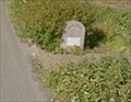
 view gallery view gallerySW7.4 km | Benchmark - Au lieu-dit "Le Molinel", au n°58 - Coutiches, France in French Benchmarks Le Repère Cylindrique du Nivellement Général se situe sur le mur de façade de la grange côté "Coutiches, face à la route. posted by: pmaupin location: Hauts-de-France, France date approved: 03/09/2020 last visited: 05/23/2020 |
 view gallery view gallery N7.4 km N7.4 km
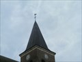
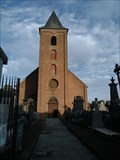
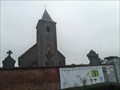
|  L'église Saint-Pierre - Rumes, Wallonie L'église Saint-Pierre - Rumes, Wallonie
in Belgium Monument Registers FR - Eglise St Pierre, autrefois propriété de l'abbaye de St Amand-les-Eaux.
EN - Church of St Pierre, formerly the property of the abbey of St Amand-les-Eaux.
NL - Kerk van St. Pierre, vroeger eigendom van de abdij van St Amand-les-Eaux. posted by: geotrouvtou59 location: Hainaut, Belgium date approved: 01/01/2022 last visited: 01/03/2022 |
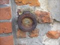
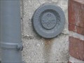
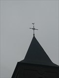 view gallery view galleryN7.4 km |  IGN Pt de Mesure: 37F61C1 - Rumes, Belgique IGN Pt de Mesure: 37F61C1 - Rumes, Belgique
in Belgium Benchmarks FR - Le repere se situe sur le somment de l'Eglise St Pierre.
EN - The marker is located on the top of the Church of St Pierre. posted by: geotrouvtou59 location: Hainaut, Belgium date approved: 01/02/2022 last visited: 01/03/2022 |
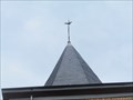
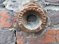
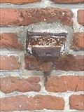 view gallery view galleryN7.4 km | IGN Pt de Mesure: Fd28 - Rumes, Belgique in Belgium Benchmarks FR - Le repere en fonte se situe sur la façade de l'Eglise St Pierre.
EN - The cast iron marker is located on the facade of the Church of St. Peter. posted by: geotrouvtou59 location: Hainaut, Belgium date approved: 01/02/2022 last visited: 01/03/2022 |
 view gallery view gallerySW7.4 km | Borne d’entrée d’agglomération - Coutiches, France in Milestones EN - Location or agglomeration entrance terminals.
FR - Bornes de localisation ou d’entrée d’agglomération. posted by: geotrouvtou59 location: Hauts-de-France, France date approved: 05/26/2020 last visited: 05/24/2020 |
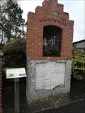
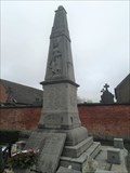 view gallery view galleryN7.4 km | monument aux morts, Rumes, Wallonie in Belgium Monument Registers FR - Dressé au centre du village, devant l'église.
EN - Set up in the center of the village, in front of the church.
NL - Opgericht in het centrum van het dorp, voor de kerk. posted by: geotrouvtou59 location: Hainaut, Belgium date approved: 01/02/2022 last visited: 01/03/2022 |
 view gallery view galleryN7.4 km |  L'église Saint-Pierre - Rumes, Belgique L'église Saint-Pierre - Rumes, Belgique
in This Old Church FR - Eglise St Pierre, autrefois propriété de l'abbaye de St Amand-les-Eaux.
EN - Church of St Pierre, formerly the property of the abbey of St Amand-les-Eaux.
NL - Kerk van St. Pierre, vroeger eigendom van de abdij van St Amand-les-Eaux. posted by: geotrouvtou59 location: Hainaut, Belgium date approved: 01/02/2022 last visited: 01/03/2022 |
|