 view gallery view gallery SE1.1 km SE1.1 km
|   Sporkenburg bei Eitelborn, Germany Sporkenburg bei Eitelborn, Germany
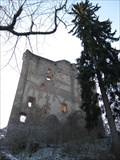
in Castles Die Sporkenburg ist eine Ruine rund ein Kilometer südlich von Eitelborn in Rheinland-Pfalz. / The Sporkenburg is a castle ruin about one kilometre south of Eitelborn in the German state of Rhineland-Palatinate. posted by:  cacher.ella cacher.ella location: Rheinland-Pfalz, Germany date approved: 01/31/2013 last visited: 08/13/2023 |
 view gallery view gallery NW1.8 km NW1.8 km
|  Neuhäuseler Arboretum - Neuhäusel - RLP - Germany Neuhäuseler Arboretum - Neuhäusel - RLP - Germany
in Arboretums Das Neuhäuseler Arboretum posted by: CADS11 location: Rheinland-Pfalz, Germany date approved: 12/30/2018 last visited: 12/21/2018 |
 view gallery view gallery E1.9 km E1.9 km
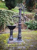
|  Fountain in Arzbach - Germany - Rhineland/Palatinate Fountain in Arzbach - Germany - Rhineland/Palatinate
in Hand Operated Water Pumps A fountain in the middle of Arzbach directly places at the main road. posted by:  ColleIsarco ColleIsarco location: Rheinland-Pfalz, Germany date approved: 04/22/2023 last visited: never |
 view gallery view gallery SW2.1 km SW2.1 km
|  Golfclub Bad Ems - Denzerheide - Germany - Rhineland/Palatinate Golfclub Bad Ems - Denzerheide - Germany - Rhineland/Palatinate
in Public and Private Golf Courses The golf course of the Golfclub Bad Ems posted by: ColleIsarco location: Rheinland-Pfalz, Germany date approved: 09/15/2017 last visited: never |
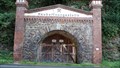
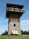 view gallery view galleryE2.6 km |  Römerturm bei Arzbach, Germany Römerturm bei Arzbach, Germany
in Ancient Roman Civilization rekonstruierter Römerturm / reconstructed Roman watch tower posted by: cacher.ella location: Rheinland-Pfalz, Germany date approved: 01/30/2013 last visited: 05/18/2014 |
 view gallery view gallery S2.9 km S2.9 km
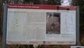
|  Der römische Bergbau auf dem Blöskopf - Bad Ems - RLP - Germany Der römische Bergbau auf dem Blöskopf - Bad Ems - RLP - Germany
in Signs of History Der römische Bergbau auf dem Blöskopf bei Bad Ems posted by: CADS11 location: Rheinland-Pfalz, Germany date approved: 01/10/2019 last visited: 01/08/2019 |
 view gallery view galleryS2.9 km | Der römische Bergbau auf dem Blöskopf - Bad Ems - RLP - Germany in Ancient Roman Civilization Der römische Bergbau auf dem Blöskopf bei Bad Ems posted by: CADS11 location: Rheinland-Pfalz, Germany date approved: 01/08/2019 last visited: 01/08/2019 |
 view gallery view galleryS2.9 km |  Römische Verhüttung von Erzen auf dem Blöskopf - Bad Ems - RLP - Germany Römische Verhüttung von Erzen auf dem Blöskopf - Bad Ems - RLP - Germany
in Iron Furnace Ruins Verhütung von Erzen am Blöskopf posted by: CADS11 location: Rheinland-Pfalz, Germany date approved: 01/18/2019 last visited: never |
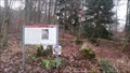
 view gallery view galleryNW3.7 km |  CoA Gemeindezentrum - Simmern, RP, Germany CoA Gemeindezentrum - Simmern, RP, Germany
in Coats of Arms Das Wappen von Simmern/WW. an der Hauswand des Gemeindezentrums. posted by: kaschper69 location: Rheinland-Pfalz, Germany date approved: 11/16/2018 last visited: 11/11/2018 |
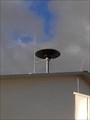 view gallery view galleryNW3.7 km |  Sirene Gemeindezentrum Simmern, RP, Germany Sirene Gemeindezentrum Simmern, RP, Germany
in Outdoor Warning Sirens On the roof of the community centre of Simmern there is an outdoor warning sirene. The community centre is located at Schulstraße 1 in 56337 Simmern. posted by: kaschper69 location: Rheinland-Pfalz, Germany date approved: 11/12/2018 last visited: 11/12/2018 |
 view gallery view galleryS3.7 km |  Neuhoffungsstollen Bad Ems - Germany - RLP Neuhoffungsstollen Bad Ems - Germany - RLP
in Mines The largest mine in Bad Ems. posted by: ColleIsarco location: Rheinland-Pfalz, Germany date approved: 08/08/2017 last visited: never |
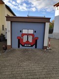 view gallery view galleryNW3.7 km |  Red car - Simmern, RP, Germany Red car - Simmern, RP, Germany
in Garage Door Art Ein rotes Auto mit BMW-Emblem als Garage Door Art in Simmern. posted by: kaschper69 location: Rheinland-Pfalz, Germany date approved: 11/14/2018 last visited: 11/13/2018 |
 view gallery view galleryNW3.7 km |  "Poststraße" - German Edition - Simmern/WW., RP, Germany "Poststraße" - German Edition - Simmern/WW., RP, Germany
in Monopoly in the Real World Poststraße is a street in the "classical" or "general" German edition. posted by: kaschper69 location: Rheinland-Pfalz, Germany date approved: 11/13/2018 last visited: 11/13/2018 |
 view gallery view galleryNW4.2 km | CoA Feuerwehr - Simmern, RP, Germany in Coats of Arms Das Wappen von Simmern/WW. an der Hauswand der Feuerwehr. posted by: kaschper69 location: Nordrhein-Westfalen, Germany date approved: 11/17/2018 last visited: 11/13/2018 |
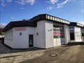 view gallery view galleryNW4.2 km |  Freiwillige Feuerwehr Westerwald/Simmern Freiwillige Feuerwehr Westerwald/Simmern
in Firehouses Freiwillige Feuerwehr von Simmern/WW. posted by: kaschper69 location: Rheinland-Pfalz, Germany date approved: 11/13/2018 last visited: 11/13/2018 |
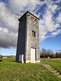 view gallery view galleryNW4.3 km |  Trafostation - Simmern, RP, Germany Trafostation - Simmern, RP, Germany
in Historic Transformer Sub-Stations Buildings Transformer Station at Görgenstraße in Simmern/WW. posted by: kaschper69 location: Rheinland-Pfalz, Germany date approved: 11/12/2018 last visited: 11/12/2018 |
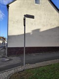
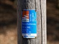
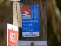 view gallery view galleryNW4.3 km |  UTM 405822 / 5584045 - Waldschluchtenweg - Vallendar, RP, Germany UTM 405822 / 5584045 - Waldschluchtenweg - Vallendar, RP, Germany
in Permanent Geographic Coordinates Koordinatenangabe entlang des Traumpfades "Waldschluchtenweg". posted by: kaschper69 location: Rheinland-Pfalz, Germany date approved: 11/26/2019 last visited: 09/23/2021 |
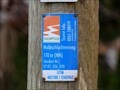
 view gallery view galleryNW4.3 km |  147 m - Waldschluchtenweg - Vallendar, RP, Germany 147 m - Waldschluchtenweg - Vallendar, RP, Germany
in Elevation Signs Elevation sign at the hiking trail "Waldschluchtenweg" near Vallendar. posted by: kaschper69 location: Rheinland-Pfalz, Germany date approved: 11/26/2019 last visited: 09/23/2021 |
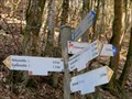
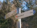
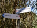 view gallery view galleryNW4.3 km |  Arrows 5 at Waldschluchtenweg - Vallendar, RP, Germany Arrows 5 at Waldschluchtenweg - Vallendar, RP, Germany
in Direction and Distance Arrows Direction and distance arrows at the hiking Trail "Waldschluchtenweg". posted by: kaschper69 location: Rheinland-Pfalz, Germany date approved: 11/28/2019 last visited: 09/23/2021 |
 view gallery view galleryNW4.3 km | UTM 405788 / 5583962 - Waldschluchtenweg - Vallendar, RP, Germany in Permanent Geographic Coordinates Koordinatenangabe entlang des Traumpfades "Waldschluchtenweg". posted by: kaschper69 location: Rheinland-Pfalz, Germany date approved: 11/26/2019 last visited: 09/23/2021 |
 view gallery view galleryNW4.3 km | 170 m - Waldschluchtenweg - Vallendar, RP, Germany in Elevation Signs Elevation sign at the hiking trail "Waldschluchtenweg" near Vallendar. posted by: kaschper69 location: Rheinland-Pfalz, Germany date approved: 11/26/2019 last visited: 09/23/2021 |
 view gallery view galleryNW4.3 km | Arrows 4 at Waldschluchtenweg - Vallendar, RP, Germany in Direction and Distance Arrows Direction and distance arrows at the hiking Trail "Waldschluchtenweg". posted by: kaschper69 location: Rheinland-Pfalz, Germany date approved: 11/28/2019 last visited: 09/23/2021 |
 view gallery view galleryNW4.3 km | UTM 405856 / 5584058 - Waldschluchtenweg - Vallendar, RP, Germany in Permanent Geographic Coordinates Koordinatenangabe entlang des Traumpfades "Waldschluchtenweg". posted by: kaschper69 location: Rheinland-Pfalz, Germany date approved: 11/26/2019 last visited: 09/23/2021 |
 view gallery view galleryNW4.3 km | 155 m - Waldschluchtenweg - Vallendar, RP, Germany in Elevation Signs Elevation sign at the hiking trail "Waldschluchtenweg" near Vallendar. posted by: kaschper69 location: Rheinland-Pfalz, Germany date approved: 11/26/2019 last visited: 09/23/2021 |
 view gallery view galleryNW4.3 km | Arrows 6 at Waldschluchtenweg - Vallendar, RP, Germany in Direction and Distance Arrows Direction and distance arrows at the hiking Trail "Waldschluchtenweg". posted by: kaschper69 location: Rheinland-Pfalz, Germany date approved: 11/28/2019 last visited: 09/23/2021 |
|