 view gallery view gallery NE6.3 km NE6.3 km
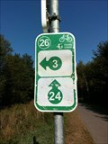
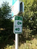
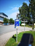
|   26 - Buchholz - BE 26 - Buchholz - BE
in Cycling Routes Ravel 45a, Buchholz, Liège, Belgium posted by:  TeamYakara TeamYakara location: Liège, Belgium date approved: 10/12/2019 last visited: 02/27/2023 |
 view gallery view gallery N6.4 km N6.4 km
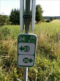
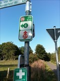
| 24 - Honsfeld - BE in Cycling Routes Ravel 45a, Honsfeld, L!ège, Belgium posted by: TeamYakara location: Liège, Belgium date approved: 10/12/2019 last visited: never |
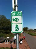 view gallery view galleryN6.8 km | 23 - Honsfeld - BE in Cycling Routes Ravel 45a, Honsfeld, Liège, Belgium posted by: TeamYakara location: Liège, Belgium date approved: 10/12/2019 last visited: never |
 view gallery view galleryNE7.9 km |  Siegfried Line- Dragon Teeth, Losheim, Germany Siegfried Line- Dragon Teeth, Losheim, Germany
in World War II Sites The "Siegfried Line", known in German as the Westwall, and to the Allies as the Dragons Teeth, was a German defensive line built during the 1930s opposite the French Maginot Line. posted by: TeamYakara location: Nordrhein-Westfalen, Germany date approved: 10/03/2019 last visited: never |
 view gallery view galleryNE8 km | 28 - Losheim - DE in Cycling Routes Kyllradweg, Knotenpunkt 28, Am Goldenbach, Losheim posted by: TeamYakara location: Nordrhein-Westfalen, Germany date approved: 10/12/2019 last visited: never |
 view gallery view galleryNE8.4 km | 27 - Losheim - DE in Cycling Routes Kyllradweg, Knotenpunkt 27, Kyllradweg L45a, Losheim posted by: TeamYakara location: Nordrhein-Westfalen, Germany date approved: 10/12/2019 last visited: never |
 view gallery view gallery SE9 km SE9 km
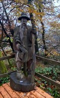
|  Schwarzer Mann, Schneifel, Sellerich, RLP, Germany Schwarzer Mann, Schneifel, Sellerich, RLP, Germany
in Outside Wooden Display Carvings Holzfigur auf einer der höchsten Erhebungen in der Eifel / Wooden figure on one of the highest elevations in the Eifel (698 m). posted by:  Tillba Tillba location: Rheinland-Pfalz, Germany date approved: 09/19/2022 last visited: never |
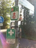
 view gallery view gallerySE9.7 km |  UTM 313244 / 5570835, Gondenbrett, Germany UTM 313244 / 5570835, Gondenbrett, Germany
in Permanent Geographic Coordinates Wegweiser im Wandergebiet Schwarzer Mann
Signposts in the Schwarzer Mann hiking area posted by: Tillba location: Rheinland-Pfalz, Germany date approved: 10/19/2022 last visited: never |
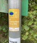
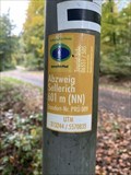 view gallery view gallerySE9.7 km |  Abzweig Sellerich, Gondenbrett, Germany - 601m (NN) Abzweig Sellerich, Gondenbrett, Germany - 601m (NN)
in Elevation Signs Höhenangabe Abzweig Sellerich
Height indication Abzweig Sellerich posted by: Tillba location: Rheinland-Pfalz, Germany date approved: 10/18/2022 last visited: never |
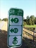 view gallery view galleryN9.8 km | 22 - Büllingen - BE in Cycling Routes Ravel L45a, Büllingen, Liège, Belgium posted by: TeamYakara location: Liège, Belgium date approved: 10/12/2019 last visited: never |
 view gallery view gallerySE10.1 km | UTM 313847/ 5570744, Wascheid, Germany in Permanent Geographic Coordinates Wegweiser im Wandergebiet Schwarzer Mann
Signposts in the Schwarzer Mann hiking area posted by: Tillba location: Rheinland-Pfalz, Germany date approved: 10/14/2022 last visited: never |
 view gallery view gallerySE10.1 km | Schwarzer Mann, Schneifel/ Wascheid, Germany - 550m (NN) in Elevation Signs Höhenangabe Schwarzer Mann
Height indication Schwarzer Mann posted by: Tillba location: Rheinland-Pfalz, Germany date approved: 10/14/2022 last visited: never |
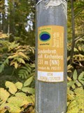 view gallery view gallerySE10.5 km | Gondenbrett: südl. Kirchenberg, Gondenbrett, Germany - 531m (NN) in Elevation Signs Höhenangabe Schwarzer Mann
Height indication Schwarzer Mann posted by: Tillba location: Rheinland-Pfalz, Germany date approved: 10/18/2022 last visited: never |
 view gallery view gallerySE10.5 km | UTM 313656 / 5570228, Gondenbrett, Germany in Permanent Geographic Coordinates Wegweiser im Wandergebiet Schwarzer Mann
Signposts in the Schwarzer Mann hiking area posted by: Tillba location: Rheinland-Pfalz, Germany date approved: 10/19/2022 last visited: never |
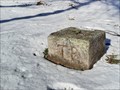 view gallery view galleryNE11.3 km |  TP - Parkplatz "Am weissen Stein" - Hellental-Udenbreth, NRW, Germany TP - Parkplatz "Am weissen Stein" - Hellental-Udenbreth, NRW, Germany
in German Trigonometric Points DE: Trigonometrischer Bodenpunkt in der Nähe des Parkplatzes "Am weissen Stein" in Hellenthal-Udenbreth.
EN: Trigonometric floor point near the parking lot "Am weissen Stein" in Hellenthal-Udenbreth. posted by: FamilieFrohne location: Nordrhein-Westfalen, Germany date approved: 02/13/2021 last visited: never |
 view gallery view gallery E11.3 km E11.3 km
|  Bragphenn, Ormont, RLP, Germany Bragphenn, Ormont, RLP, Germany
in Hiking and walking trailheads Das Bragphenn ist ein Sattelregen-Hochmoor in der Nähe von Ormont
The Bragphenn is a saddle rain raised bog near Ormont posted by: Tillba location: Rheinland-Pfalz, Germany date approved: 10/04/2022 last visited: never |
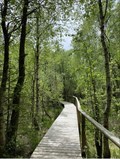 view gallery view galleryE11.3 km |  Bragphenn, Ormond, RLP, Germany Bragphenn, Ormond, RLP, Germany
in Non-Coastal Boardwalks Das Bragphenn ist ein Sattelregen-Hochmoor in der Nähe von Ormont
The Bragphenn is a saddle rain raised bog near Ormont posted by: Tillba location: Rheinland-Pfalz, Germany date approved: 10/16/2022 last visited: never |
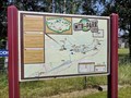
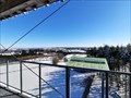 view gallery view galleryNE11.4 km |  Aussichtsturm "Am weissen Stein" - Hellenthal-Udenbreth, NRW, Germany Aussichtsturm "Am weissen Stein" - Hellenthal-Udenbreth, NRW, Germany
in Orientation Tables DE: Orientierungstafeln am Aussichtsturm "Am weissen Stein" im gleichnamigen Wintersportgebiet in der Eifel.
EN: Orientation boards at the observation tower "Am weissen Stein" in the winter sports area of the same name in the Eifel. posted by: FamilieFrohne location: Nordrhein-Westfalen, Germany date approved: 02/13/2021 last visited: never |
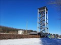 view gallery view galleryNE11.4 km |  Aussichtsturm "Am weissen Stein" - Hellenthal-Udenbreth, NRW, Germany Aussichtsturm "Am weissen Stein" - Hellenthal-Udenbreth, NRW, Germany
in Look-Out Towers DE: Der Aussichtsturm "Am weissen Stein" befindet sich im gleichnamigen Wintersportgebiet in der Eifel.
EN: The observation tower "Am weissen Stein" is located in the winter sports area of the same name in the Eifel. posted by: FamilieFrohne location: Nordrhein-Westfalen, Germany date approved: 02/13/2021 last visited: never |
 view gallery view galleryN11.4 km | 19 - Tollersheild - BE in Cycling Routes Ravel L45a, Büllingen, Liège, Belgium posted by: TeamYakara location: Liège, Belgium date approved: 10/12/2019 last visited: never |
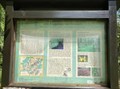
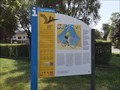
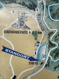 view gallery view gallerySE11.9 km |  Wandern und erholen (Wanderkarte), Wascheid, RLP, Germany Wandern und erholen (Wanderkarte), Wascheid, RLP, Germany
in 'You Are Here' Maps Wanderkarte am Wascheider Stausee
Hiking map at the Wascheider Reservoir posted by: Tillba location: Rheinland-Pfalz, Germany date approved: 10/01/2022 last visited: never |
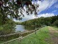 view gallery view gallerySE11.9 km |  Stausee Wascheid, Gondenbrett-Wascheid, RLP, Germany Stausee Wascheid, Gondenbrett-Wascheid, RLP, Germany
in Water Dams Kleiner Stausee am Fuß der Schneifel
Small reservoir at the foot of the Schneifel posted by: Tillba location: Rheinland-Pfalz, Germany date approved: 10/05/2022 last visited: never |
 view gallery view gallery SW12.1 km SW12.1 km
|  MTB-Park St. Vith - St. Vith - Belgium MTB-Park St. Vith - St. Vith - Belgium
in Mountain Bike Trailheads A trail near the cycling-path in East-Belgium posted by: ColleIsarco location: Liège, Belgium date approved: 07/17/2020 last visited: never |
 view gallery view gallerySW12.1 km | 48 - St. Vith - BE in Cycling Routes A cycling-route waymark is placed at 'Am Stellwerk' near the (former) railway-station of St. Vith. posted by: ColleIsarco location: Liège, Belgium date approved: 10/30/2020 last visited: never |
 view gallery view gallerySW12.1 km |  Vennbahn - St. Vith Belgium Vennbahn - St. Vith Belgium
in Rails to Trails A bike-trail connecting 3 countries posted by: ColleIsarco location: Liège, Belgium date approved: 09/30/2020 last visited: 03/04/2023 |
|