 view gallery view gallery NW5 km NW5 km
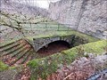
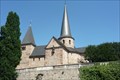
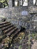
|   Burgruine Steckelburg Burgruine Steckelburg
in Preserved Architectural Remnants and Ruins Burgruine Steckelburg posted by:  IrrGeist IrrGeist location: Hessen, Germany date approved: 04/22/2023 last visited: never |
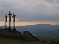 view gallery view gallery E24.6 km E24.6 km
|  Kreuzberg (Rhön) - Bischofsheim a. d. Rhön, Lk Rhön-Grabfeld, Bayern, D Kreuzberg (Rhön) - Bischofsheim a. d. Rhön, Lk Rhön-Grabfeld, Bayern, D
in Wikipedia Entries Der Kreuzberg ist ein 927,8 m hoher Berg in der Rhön.
---
The "Kreuzberg" is a 3044 feet high mountain in the Rhön. posted by: lumbricus location: Bayern, Germany date approved: 10/21/2011 last visited: 04/11/2020 |
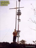 view gallery view galleryE24.6 km |  Kreuzberg Kreuzberg
in Mountain Summits Kreuzberg in the Rhon in Germany posted by: FamGrit location: Bayern, Germany date approved: 01/24/2006 last visited: 04/11/2020 |
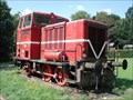 view gallery view gallery W24.9 km W24.9 km
|  MaK diesel locomotive No. 220060, Birstein, DE MaK diesel locomotive No. 220060, Birstein, DE
in Locomotives MaK diesel locomotive No. 220060, Birstein, DE posted by:  Krxlvop Krxlvop location: Hessen, Germany date approved: 06/11/2016 last visited: 12/19/2017 |
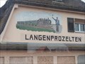 view gallery view gallery S26.2 km S26.2 km
|  Train and Conductor - Langenprozelten/Gemünden / Bayern/ Deutschland Train and Conductor - Langenprozelten/Gemünden / Bayern/ Deutschland
in Murals A nice train on a house wall. posted by: Bianka11 location: Bayern, Germany date approved: 03/24/2014 last visited: never |
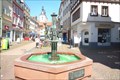 view gallery view gallery N28.2 km N28.2 km
|  Brunnen mit Wasserträgerinnen - Fulda, Hessen Brunnen mit Wasserträgerinnen - Fulda, Hessen
in Fountains This fountain is located in the Marktstraße in Fulda. It shows three women carrying water posted by: Eibacher Kuckuck location: Hessen, Germany date approved: 07/07/2015 last visited: 11/14/2018 |
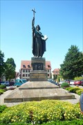 view gallery view galleryN28.5 km |  Bonifatius - Fulda, Hesse, Germany Bonifatius - Fulda, Hesse, Germany
in Statues of Religious Figures On the Bonifatiusplatz, opposite the Baroque castle in Fulda, there is a four-meter high bronze statue of St. Boniface posted by: Eibacher Kuckuck location: Hessen, Germany date approved: 07/07/2015 last visited: 12/15/2019 |
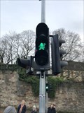 view gallery view galleryN28.5 km |  Saint Boniface crossing - Fulda, Germany Saint Boniface crossing - Fulda, Germany
in Uncommon Crossing Signs At Fulda, the burial site of Saint Boniface, the pedestrian traffic lights shows an interesting variant of the normal ones. posted by: André de Montbard location: Hessen, Germany date approved: 10/11/2021 last visited: never |
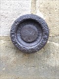 view gallery view galleryN28.5 km |  Königlich Preußische Landesaufnahme - Dom, Fulda, HE-DE Königlich Preußische Landesaufnahme - Dom, Fulda, HE-DE
in German Benchmarks KPL stud at the cathedral of Fulda. posted by: André de Montbard location: Hessen, Germany date approved: 11/16/2020 last visited: never |
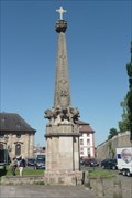 view gallery view galleryN28.5 km |  Obeliske am Domplatz, Fulda Obeliske am Domplatz, Fulda
in Obelisks Next to the two domed chapels of the Fulda cathedral stand a pair of sandstone obelisks about 11 metres high, the function of which, besides being decorative, is to make the facade appear broader posted by: Eibacher Kuckuck location: Hessen, Germany date approved: 07/10/2015 last visited: 12/15/2019 |
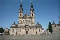 view gallery view galleryN28.6 km |  Fuldaer Dom - Fulda, Hessen Fuldaer Dom - Fulda, Hessen
in Official Local Tourism Attractions Der Fuldaer Dom ist die bedeutendste Barockkirche Hessens und das Wahrzeichen Fuldas | The Cathedral St. Salvator is the most important Baroque church of Hesse and probably the most visited place in Fulda posted by: Eibacher Kuckuck location: Hessen, Germany date approved: 07/06/2015 last visited: 12/15/2019 |
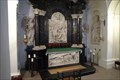 view gallery view galleryN28.6 km |  Bonifatius - Fulda Cathedral, Hessen Bonifatius - Fulda Cathedral, Hessen
in Grave of a Famous Person The remains of Saint Boniface (Latin: Bonifatius), the "Apostle of the Germans" rest in a sarcophagus in the Fulda Cathedral, which became a site of pilgrimage. posted by: Eibacher Kuckuck location: Hessen, Germany date approved: 08/31/2015 last visited: 12/10/2017 |
 view gallery view galleryN28.6 km |  Michaelskirche - Fulda, Hessen, Germany Michaelskirche - Fulda, Hessen, Germany
in Medieval Churches St. Michael's Church (German: Michaelskirche) in Fulda was built in the Carolingian architectural style in the years 820-822. It is considered to be the oldest Holy Sepulchre church in Germany posted by: Eibacher Kuckuck location: Hessen, Germany date approved: 07/03/2015 last visited: 12/15/2019 |
 view gallery view galleryN28.6 km |  Fulda, Gemany Fulda, Gemany
in Train Stations/Depots Fulda station is an important transport hub of the German railway network in the east Hessian city of Fulda. posted by: superstein location: Hessen, Germany date approved: 09/03/2013 last visited: 02/21/2018 |
 view gallery view gallery NE29.9 km NE29.9 km
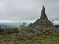
|  Fliegerdenkmal, Wasserkuppe, Hessen Fliegerdenkmal, Wasserkuppe, Hessen
in World War I Memorials and Monuments Das Fliegerdenkmal steht auf der Wasserkuppe, dem höchsten Berg der Rhön, auch Berg der Flieger genannt.
Es besteht aus Basaltsteinen als Fundament und einer Adler-Skulptur aus Bronze. posted by: The Redheads location: Hessen, Germany date approved: 12/05/2017 last visited: 10/09/2023 |
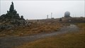 view gallery view galleryNE29.9 km |  Wasserkuppe - The Highest Point in Hessen - Hessen, Germany Wasserkuppe - The Highest Point in Hessen - Hessen, Germany
in Geographic High Points The Wasserkuppe is a mountain within the German state of Hesse. With 950 m (3,120 ft) elevation is it the highest peak within the German state of Hesse. posted by: friesede location: Hessen, Germany date approved: 05/12/2017 last visited: 10/09/2023 |
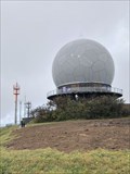 view gallery view galleryNE30.1 km |  Radome, Wasserkuppe - Gersfeld/Rhön, HE-DE Radome, Wasserkuppe - Gersfeld/Rhön, HE-DE
in Abandoned Air Force Radar Sites Radome of a former US Air Force Radar Site, first part of "Gunpost", securing air traffic to Berlin. posted by: André de Montbard location: Hessen, Germany date approved: 10/27/2020 last visited: 07/05/2020 |
 view gallery view galleryNE30.4 km |  ORIGIN Fulda River - Gersfeld/Rhön, HE-DE ORIGIN Fulda River - Gersfeld/Rhön, HE-DE
in River Origins, Destinations and Confluences Source of the River Fulda, which build together with River Werra the Weser River. posted by: André de Montbard location: Hessen, Germany date approved: 10/28/2020 last visited: 07/05/2020 |
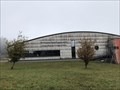 view gallery view galleryNE30.6 km |  Deutsches Segelflugmuseum mit Modellflug - Gersfeld/Rhön, HE-DE Deutsches Segelflugmuseum mit Modellflug - Gersfeld/Rhön, HE-DE
in Aviation Museums The Deutsches Segelflugmuseum mit Modellflug (English: German Glider Museum with Model Aircraft), situated on the Wasserkuppe in the German state of Hesse is the national gliding museum, opened in 1987. posted by: André de Montbard location: Hessen, Germany date approved: 11/29/2020 last visited: never |
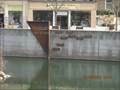 view gallery view galleryE32.2 km |  Hochwassermarke in Bad Kissingen/Bayern/Deutschland Hochwassermarke in Bad Kissingen/Bayern/Deutschland
in High Level Marks Hochwassermarke in Bad Kissingen / Flood elevation marker/ River Fränkische Saale posted by: *Team Krombaer* location: Bayern, Germany date approved: 03/29/2012 last visited: 10/15/2014 |
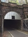
 view gallery view galleryNE33.8 km |  Milseburgtunnel, Hilders, Germany Milseburgtunnel, Hilders, Germany
in Abandoned Train Tunnels Der 1889 für die Eisenbahn eröffnete Milseburgtunnel ist nun Deutschland's längster Fahrradwegtunnel (1173 Meter) *** This tunnel was built in 1889 for the railway and now is used for bicycles posted by: 4spring location: Hessen, Germany date approved: 11/15/2017 last visited: 04/29/2017 |
 view gallery view galleryNE33.8 km |  Milseburgtunnel, 1889, Hilders, Germany Milseburgtunnel, 1889, Hilders, Germany
in Dated Architectural Structures Multifarious Der 1889 eröffnete Milseburgtunnel ist Deutschland's längster Fahrradwegtunnel (1173 Meter) *** This tunnel was built in 1889 for the railway and now is used for bicycles posted by: 4spring location: Hessen, Germany date approved: 11/12/2017 last visited: 04/29/2017 |
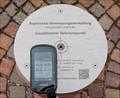
 view gallery view galleryS34 km |  N 49° 59.7497' E 9° 34.4099' - Geodätischer Referenzpunkt — Lohr am Main, Germany N 49° 59.7497' E 9° 34.4099' - Geodätischer Referenzpunkt — Lohr am Main, Germany
in Permanent Geographic Coordinates Geodetic reference point determined by the Bayerische Vermessungsverwaltung (Bavarian Surveying Administration) posted by: prussel location: Bayern, Germany date approved: 06/29/2017 last visited: never |
 view gallery view galleryS34 km |  163,1 m ü.NN - Geodätischer Referenzpunkt — Lohr am Main, Germany 163,1 m ü.NN - Geodätischer Referenzpunkt — Lohr am Main, Germany
in Elevation Signs Geodetic reference point determined by the Bayerische Vermessungsverwaltung (Bavarian Surveying Administration) showing the coordinates and a height of 163,1 m ü.NN posted by: prussel location: Bayern, Germany date approved: 06/27/2017 last visited: never |
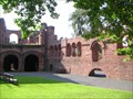 view gallery view galleryW34.3 km |  Kaiserpfalz Gelnhausen Kaiserpfalz Gelnhausen
in Castles Foundation and preferred abode of Emperor Frederick I. (called Barbarossa; 1122 - 1190). posted by: thengel location: Hessen, Germany date approved: 04/04/2010 last visited: 12/13/2017 |
|