 view gallery view gallery NW0.6 km NW0.6 km
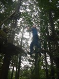
|   Climbing parcours camping Roptai - Ave-et-Auffe, Belgium Climbing parcours camping Roptai - Ave-et-Auffe, Belgium
in Ropes Course The camping Roptai has a fun climbing parcours posted by:  Becktracker Becktracker location: Namur, Belgium date approved: 03/03/2021 last visited: 08/19/2016 |
 view gallery view gallery SE3.2 km SE3.2 km
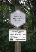
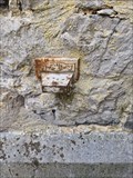
|  Chateau de Resteigne - Tellin - Belgique. 180m Chateau de Resteigne - Tellin - Belgique. 180m
in Elevation Signs Signe d'altitude du lieu Château de Resteigne posted by: franketmuriel location: Luxembourg, Belgium date approved: 10/22/2017 last visited: 03/17/2019 |
 view gallery view gallery NE3.7 km NE3.7 km
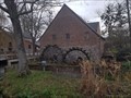
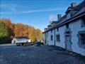
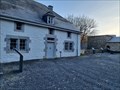
|  Domaine du Vieux Moulin - Eprave - Belgique Domaine du Vieux Moulin - Eprave - Belgique
in Water Mills FR] Moulin à eau du XVe siècle restauré en 1993. [EN] 15th century watermill restored in 1993. posted by: PaulLassiter location: Luxembourg, Belgium date approved: 12/21/2020 last visited: never |
 view gallery view galleryNE3.9 km |  Domaine du Vieux Moulin - Eprave - Belgique Domaine du Vieux Moulin - Eprave - Belgique
in Wikipedia Entries [FR]Moulin à eau du XVe siècle restauré en 1993. [EN] 15th century watermill restored in 1993. posted by: PaulLassiter location: Luxembourg, Belgium date approved: 12/20/2020 last visited: never |
 view gallery view gallery SW5 km SW5 km
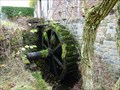
| Moulin de Lomprez - Lomprez, Belgium in Water Mills A Water Mill located at Vieille-Route 15 in Lomprez (Wellin), Belgium. The mill was initially built in the 12th century and was used for milling grain. It was also part of a defence line. It is restored in 1996. It is driven by a water wheel of 4m. posted by: Hibje location: Luxembourg, Belgium date approved: 11/24/2009 last visited: 08/14/2018 |
 view gallery view gallerySW5.1 km |  NGI Meetpunt: Thi12 - Lomprez NGI Meetpunt: Thi12 - Lomprez
in Belgium Benchmarks A Belgium benchmark at the church in Lomprez posted by: kallehaugerne location: Luxembourg, Belgium date approved: 10/08/2023 last visited: never |
 view gallery view gallery S5.8 km S5.8 km
| Point de vue du Belvédère. Wellin, Belgique. 335 m. in Elevation Signs Signe d'altitude Point de vue du Belvédère. posted by: franketmuriel location: Luxembourg, Belgium date approved: 04/01/2020 last visited: never |
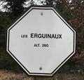 view gallery view galleryS6.1 km | Les Erguinaux. Wellin, Belgique. 260 m. in Elevation Signs Signe d'altitude Les Erguinaux posted by: franketmuriel location: Luxembourg, Belgium date approved: 04/01/2020 last visited: never |
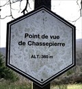 view gallery view galleryS6.4 km | Point de vue de Chassepierre. Wellin, Belgique. 360 m. in Elevation Signs Signe d'altitude du Point de vue de Chassepierre. posted by: franketmuriel location: Luxembourg, Belgium date approved: 04/01/2020 last visited: never |
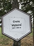 view gallery view gallerySW7.9 km | Signe d'altitude du lieu Croix Victoire - Wellin - Belgique - 350 m in Elevation Signs Signe d'altitude du lieu Croix Victoire posted by: franketmuriel location: Luxembourg, Belgium date approved: 08/15/2018 last visited: never |
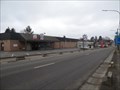 view gallery view galleryNE7.9 km |  Aldi Store Rochefort Belgium Aldi Store Rochefort Belgium
in ALDI Stores Aldi Store Rochefort posted by: Alfredo4 location: Namur, Belgium date approved: 12/04/2011 last visited: 04/19/2014 |
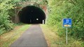 view gallery view galleryNW10 km |  Railway line 150 - Houyette, Namur, Belgium Railway line 150 - Houyette, Namur, Belgium
in Rails to Trails This tunnel in Hour/Havenne used to be a train track and is now a cycling / walking path. posted by:  T-Team! T-Team! location: Namur, Belgium date approved: 09/04/2022 last visited: never |
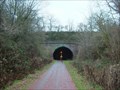 view gallery view galleryNW10.5 km |  Belgium - Former line 150 - Hour-Havenne tunnel Belgium - Former line 150 - Hour-Havenne tunnel
in Abandoned Train Tunnels Belgium - Province Namur - Hour-Havenne tunnel in Houyet commune. posted by: hh1 location: Namur, Belgium date approved: 12/27/2009 last visited: 09/03/2022 |
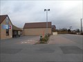 view gallery view gallery W12.1 km W12.1 km
| Aldi Store Beauraing Belgium in ALDI Stores Aldi Store Beauraing Belgium posted by: Alfredo4 location: Namur, Belgium date approved: 12/04/2011 last visited: 08/21/2017 |
 view gallery view galleryS13 km | Passerelle de Chafté-Louis - Libin - Belgique, 260 m. in Elevation Signs [FR] Signal d'altitude près de la passerelle sur une des promenades entre les rivières Lesse et Lomme. [EN] Altitude signal near the bridge on one of the parkways between the Lesse and Lomme rivers. posted by: PaulLassiter location: Luxembourg, Belgium date approved: 07/16/2019 last visited: never |
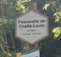 view gallery view galleryS13 km |  49° 59' 30,96" 05° 08' 39,89" - Passerelle de Chafté-Louis - Libin - Belgique 49° 59' 30,96" 05° 08' 39,89" - Passerelle de Chafté-Louis - Libin - Belgique
in Permanent Geographic Coordinates [FR] Coordonnées géographiques DMS se trouvant sur le panneau de randonnée. [EN] Geographical coordinates DMS located on the hiking sign. posted by: PaulLassiter location: Luxembourg, Belgium date approved: 07/16/2019 last visited: never |
 view gallery view galleryNE14.3 km | IGN Pt de mesure: 59C59C1 HARGIMONT (Marche-en-Famenne) in Belgium Benchmarks IGN Pt de mesure: 59C59C1 - église "Saint-Gobert" HARGIMONT (Marche-en-Famenne) posted by: franketmuriel location: Luxembourg, Belgium date approved: 01/17/2018 last visited: 08/14/2018 |
 view gallery view gallery E14.5 km E14.5 km
| Fourneau Saint-Michel - Saint-Hubert - Belgique in Wikipedia Entries [FR] Ancien fourneau de l’abbaye de Saint-Hubert. [EN] Former furnace of the abbey of Saint-Hubert. posted by: PaulLassiter location: Luxembourg, Belgium date approved: 11/29/2021 last visited: never |
 view gallery view galleryE14.5 km |  Ancien fourneau Saint-Michel et ses bâtiments - Saint-Hubert - Belgique Ancien fourneau Saint-Michel et ses bâtiments - Saint-Hubert - Belgique
in Belgium Monument Registers [FR] Ancien fourneau de l’abbaye de Saint-Hubert. [EN] Former furnace of the abbey of Saint-Hubert. posted by: PaulLassiter location: Luxembourg, Belgium date approved: 11/29/2021 last visited: never |
 view gallery view galleryNE14.8 km |  Vous êtes ici - Prés de la Wamme réserve naturelle RNOB - Hargimont (Marche-en-Famenne) Vous êtes ici - Prés de la Wamme réserve naturelle RNOB - Hargimont (Marche-en-Famenne)
in 'You Are Here' Maps L'indication "vous êtes ici" se trouve sur un panneau d'information de la réserve naturelle privée RNOB posted by: franketmuriel location: Luxembourg, Belgium date approved: 01/15/2018 last visited: never |
 view gallery view galleryNE14.8 km | Prés de la Wamme - Hargimont (Marche-en-Famenne) - Belgique 260m in Elevation Signs Signe d'altitude du lieu Prés de la Wamme posted by: franketmuriel location: Luxembourg, Belgium date approved: 01/15/2018 last visited: never |
 view gallery view galleryNE14.8 km | Le château et la ferme de Jemeppe - Hargimont - Belgique in Belgium Monument Registers Le château de Jemeppe est une construction implantée dans un vaste parc. Il s’agit d’un château médiéval dont la partie la plus ancienne est le donjon du XIVe siècle posted by: franketmuriel location: Luxembourg, Belgium date approved: 03/03/2018 last visited: 08/14/2018 |
 view gallery view gallerySW15.9 km |  N50 E005 - Haut-Fays, Belgium N50 E005 - Haut-Fays, Belgium
in Confluence Spots An easy accessible Confluence Point in a forest near Haut-Fays, Belgium. posted by: Hibje location: Namur, Belgium date approved: 11/23/2009 last visited: 04/07/2022 |
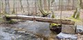 view gallery view galleryE15.9 km |  Pont Mauricy - Saint-Hubert, Luxembourg, Belgique Pont Mauricy - Saint-Hubert, Luxembourg, Belgique
in Hiking Path Footbridges [FR] Passerelle permettant d'enjamber le ruisseau de la Masblette [EN] Footbridge to cross the Masblette stream. posted by: Waldog location: Luxembourg, Belgium date approved: 04/05/2019 last visited: 11/29/2021 |
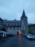 view gallery view galleryNW16.3 km | Collégiale Saint-Hadelin - Celles - Belgique in Wikipedia Entries [FR] Edifice religieux construit au XIe siècle. [EN] Religious building built in the 11th century. posted by: PaulLassiter location: Namur, Belgium date approved: 12/29/2020 last visited: never |
|