 view gallery view gallery SW7.4 km SW7.4 km
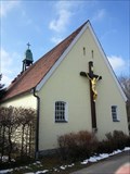
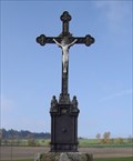
|   Churchyard Cross - Friedhofstraße/ Immenreuth/ Deutschland Churchyard Cross - Friedhofstraße/ Immenreuth/ Deutschland
in Churchyard Crosses A churchyard cross near Immenreuth, Bavaria, Germany posted by:  *Team Krombaer* *Team Krombaer* location: Bayern, Germany date approved: 03/18/2016 last visited: never |
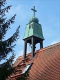 view gallery view gallerySW7.4 km |  Belltower Churchyardchapel - Immenreuth/Germany/BY Belltower Churchyardchapel - Immenreuth/Germany/BY
in Bell Towers Belltower of Churchyardchapel Immenreuth, Germany posted by: *Team Krombaer* location: Bayern, Germany date approved: 03/20/2016 last visited: never |
 view gallery view gallery NE8 km NE8 km
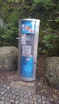
|  Penny Smasher of Felsenlabyrinth Luisenburg - Wunsiedel/ Bayern/ Deutschland Penny Smasher of Felsenlabyrinth Luisenburg - Wunsiedel/ Bayern/ Deutschland
in Penny Smashers Here you can find the penny smasher of "Felsenlabyrinth Luisenburg". posted by: Bianka11 location: Bayern, Germany date approved: 07/23/2017 last visited: never |
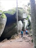 view gallery view galleryNE8 km |  Felsenlabyrinth Luisenburg Felsenlabyrinth Luisenburg
in Labyrinths Felsenlabyrinth Luisenburg posted by: aendgraend location: Bayern, Germany date approved: 10/06/2015 last visited: 06/05/2009 |
 view gallery view gallery NW11.1 km NW11.1 km
|  Wasserscheide im Fichtelgebirge - Bayern, Deutschland Wasserscheide im Fichtelgebirge - Bayern, Deutschland
in Watershed Markers and Monuments A water shed marker at B 303 (Fichtelgebirge). posted by: *Team Krombaer* location: Bayern, Germany date approved: 07/31/2022 last visited: never |
 view gallery view galleryNW12.7 km |  HP - Marienquelle - Ochsenkopfregion, BY, Germany HP - Marienquelle - Ochsenkopfregion, BY, Germany
in German Benchmarks [DE]Höhenmeßpunkt an der Mariequelle, Bayern, Deutschland. [GB] Benchmark natural spring 'Marienquelle', Bavaria, Germany. posted by: *Team Krombaer* location: Bayern, Germany date approved: 10/02/2018 last visited: never |
 view gallery view galleryNW12.9 km |  32U 702215 5545793 - Weißmainquelle, BY, Germany 32U 702215 5545793 - Weißmainquelle, BY, Germany
in Permanent Geographic Coordinates Koordinatenangabe an der Weißmainquelle im Fichtelgebirge, Bayarn.// Permanent coordinate at so-called 'Whitemain spring' in the Spruce-mountain, Bavaria. posted by: *Team Krombaer* location: Bayern, Germany date approved: 09/30/2018 last visited: never |
 view gallery view galleryNE13.2 km |  Historische Postmeilensäule - Holenbrunn/Germany/BY Historische Postmeilensäule - Holenbrunn/Germany/BY
in Milestones Rekonstuktierte Postmeilensäule an der Eisenbahnunterführung in Holenbrunn, Bayern, Deutschland posted by: *Team Krombaer* location: Bayern, Germany date approved: 07/07/2016 last visited: never |
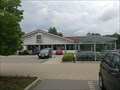 view gallery view galleryNE13.4 km |  ALDI Sud Supermarket - Marktredwitz, Bayern, DE ALDI Sud Supermarket - Marktredwitz, Bayern, DE
in ALDI Stores The usual supermarket ALDI in Marktredwitz, Bayern posted by: Petrs11 location: Bayern, Germany date approved: 07/25/2015 last visited: 03/29/2023 |
 view gallery view galleryNW13.7 km |  Vermessungspunkt I. Ordnung - Ochsenkopfgipfel, BY, Deutschland Vermessungspunkt I. Ordnung - Ochsenkopfgipfel, BY, Deutschland
in German Trigonometric Points Vermessungssäule der kön. sächs. Triangulierung in Bayern. posted by: *Team Krombaer* location: Bayern, Germany date approved: 10/01/2018 last visited: 04/06/2024 |
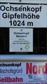
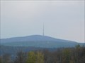 view gallery view galleryNW13.7 km |  Der Ochsenkopf (1024 m) im Fichtelgebirge - BY/Germany Der Ochsenkopf (1024 m) im Fichtelgebirge - BY/Germany
in Wikipedia Entries Der Ochsenkopf zwischen Warmensteinach und Bischofsgrün im oberfränkischen Landkreis Bayreuth ist mit 1024 m ü. NHN der zweithöchste Berg des Fichtelgebirges. // 2nd highest mountain in Fichtelgebirge: Ochsenkopf(1024 m ü. NHN ) posted by: *Team Krombaer* location: Bayern, Germany date approved: 04/17/2017 last visited: 04/06/2024 |
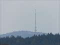 view gallery view galleryNW13.7 km |  Sender Ochsenkopf im Fichtelgebirge - Bischofsgrün/BY/Germany Sender Ochsenkopf im Fichtelgebirge - Bischofsgrün/BY/Germany
in Radio and Television Transmitter Towers [DE] Der Sender "Ochsenkopf" im Fichtelgebirge [EN] A huge broadcast tower in the middlemountain "Fichtelgebirge". posted by: *Team Krombaer* location: Bayern, Germany date approved: 04/18/2017 last visited: 04/06/2024 |
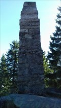
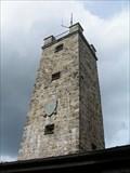 view gallery view galleryNW13.7 km |  Asenturm am Ochsenkopf - Fichtelgebirge, Bavaria, Germany Asenturm am Ochsenkopf - Fichtelgebirge, Bavaria, Germany
in Look-Out Towers Asenturm auf dem Gipfel des Ochsenkopfes im Fichtelgebirge (1024 m ü.NN). --- Asen tower high up the mountain Ochsenkopf (3,360 ft) in the Fichtelgebirge. posted by: lumbricus location: Bayern, Germany date approved: 08/11/2017 last visited: 04/06/2024 |
 view gallery view galleryNW13.7 km | 32U 701165 5545827 - Ochsenkopf, BY, Germany in Permanent Geographic Coordinates Koordinatenangabe Gipfelbereich Ochsenkopf im Fichtelgebirge, Bayarn.// Permanent coordinate on top of so-called 'Ochsenkopf' in the Spruce-mountain, Bavaria. posted by: *Team Krombaer* location: Bayern, Germany date approved: 10/02/2018 last visited: 04/06/2024 |
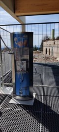 view gallery view galleryNW13.7 km | Penny Smasher Ochsenkopf-Seilbahn Gipfelstation, Bavaria, Germany in Penny Smashers Dieser Münzprägeautomat steht in der Gipfelstation der Ochsenkopf-Seilbahn, die 2023 neu gebaut wurde. posted by: aendgraend location: Bayern, Germany date approved: 04/21/2024 last visited: never |
 view gallery view gallery E14.3 km E14.3 km
|  Marter- Webcamcache Marter- Webcamcache
in Christian Crosses Die Marter oder das Marterl besteht aus einer Steinsäule, die oben eine Kreuzigungsdarstellung aus Guss schmückt. Das Kleindenkmal steht in Fuchsmühl am Wegesrand des bekannten Schremsengassel, das im Grundkataster als Mühlenweg eingetragen ist. posted by:  imgruenen.de imgruenen.de location: Bayern, Germany date approved: 11/27/2011 last visited: never |
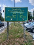
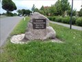 view gallery view gallerySW14.5 km | Europäische Hauptwasserscheide - Speichersdorf/BY/Germany in Watershed Markers and Monuments Here in Speichersdorf exists a nice location with name and elevation on it. posted by: *Team Krombaer* location: Bayern, Germany date approved: 06/13/2018 last visited: never |
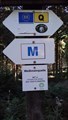
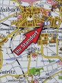 view gallery view gallerySW14.6 km |  Infosign "Bahnhofsvorplatz" - Kirchenlaibach-Speichersdorf/BY/Germany Infosign "Bahnhofsvorplatz" - Kirchenlaibach-Speichersdorf/BY/Germany
in 'You Are Here' Maps Sign with map regarding the surrounding here at trainstation Kirchenlaibach. posted by: *Team Krombaer* location: Bayern, Germany date approved: 03/19/2017 last visited: never |
 view gallery view gallerySW14.6 km |  462 m - Bahnhof - Kirchenlaibach, BY, Deutschland 462 m - Bahnhof - Kirchenlaibach, BY, Deutschland
in Elevation Signs [DE] Höhenangabe an einer Wandertafel am Bahnhofsvorplatz.
[EN] Height indication on a hiking board at the station forecourt. posted by: *Team Krombaer* location: Bayern, Germany date approved: 10/08/2020 last visited: never |
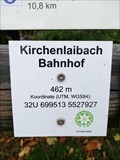 view gallery view gallerySW14.6 km | UTM 32U 699513 / 6627927 - Bahnhof - Kirchenlaibach, BY, Deutschland in Permanent Geographic Coordinates Koordinatentafel am Kirchenlaibacher Bahnhofsvorplatz. posted by: *Team Krombaer* location: Bayern, Germany date approved: 10/11/2020 last visited: never |
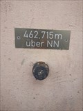 view gallery view gallerySW14.8 km | Elevation Signs 462,715 m über NN Bahnstation Kirchenlaibach, Germany/BY in Elevation Signs [DE] Am Bahnhof Kirchenlaibach befindet sich diese Höhenangabe.
[EN] This Elevation Sign is located at the trainstation Kirchenlaibach. posted by: *Team Krombaer* location: Bayern, Germany date approved: 03/14/2016 last visited: never |
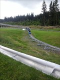 view gallery view galleryNW15.1 km |  Alpine Coaster - Bischofsgrün/BY/Germany Alpine Coaster - Bischofsgrün/BY/Germany
in Bobsleigh Chutes and Mountain Slides Alpine Coaster Ochsenkopf since 2015. posted by: *Team Krombaer* location: Bayern, Germany date approved: 08/24/2017 last visited: 06/13/2009 |
  N15.4 km N15.4 km
|  Stillgelegtes Uranexplorationsbergwerk im Fichtelgebirge Stillgelegtes Uranexplorationsbergwerk im Fichtelgebirge
in Mines ehemaliges Uranbergwerk nahe Weißenstadt/ Bayern/ Deutschland posted by: *Team Krombaer* location: Bayern, Germany date approved: 07/30/2012 last visited: never |
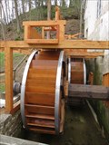 view gallery view gallery W15.8 km W15.8 km
|  Water wheel on Scherzenmuhle - Weidenberg, BY, Germany Water wheel on Scherzenmuhle - Weidenberg, BY, Germany
in Working Water Wheels The water wheel is located on the Scherzenmuhle mill in Weidenberg. The mill is historical one - it's functioning as open air museum, but the wheel is still working. posted by: virtual.franken location: Bayern, Germany date approved: 04/20/2015 last visited: 09/25/2015 |
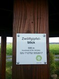 view gallery view galleryN15.9 km | 'Twelve-summits-view' - Röslau/Germany/BY in Elevation Signs Here at'Twelve-summits-view' in Röslau, a small plaque shows the hight of 599 m posted by: *Team Krombaer* location: Bayern, Germany date approved: 05/11/2016 last visited: never |
|