 view gallery view gallery N6 km N6 km
|   CNHS - Tilting Cultural Landscape - Fogo Island, Newfoundland and Labrador CNHS - Tilting Cultural Landscape - Fogo Island, Newfoundland and Labrador
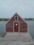
in Canadian National Historic Sites Tilting is a living cultural landscape that encompasses natural and built places that together depict traditional outport life. posted by:  Trail Blaisers Trail Blaisers location: Newfoundland and Labrador, Canada date approved: 08/03/2015 last visited: never |
 view gallery view gallery NW12.1 km NW12.1 km
|  Softball Diamond - Joe Batt's Arm South, Newfoundland and Labrador Softball Diamond - Joe Batt's Arm South, Newfoundland and Labrador
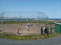
in Amateur Baseball Fields There are some picturesque settings for playing ball, but this has to be up there. Looking out over Joe Batt's Arm and the North Atlantic. On "Iceberg Alley", it's not uncommon this time of year to have an iceberg float by during the game. posted by: Trail Blaisers location: Newfoundland and Labrador, Canada date approved: 07/23/2015 last visited: never |
 view gallery view galleryNW15.8 km |  Lion's Den (Ghost Town) - Fogo, Newfoundland and Labrador Lion's Den (Ghost Town) - Fogo, Newfoundland and Labrador
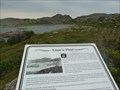
in Ghost Towns Lion's Den is one of four abandoned communities around the Town of Fogo on Fogo Island. Absolutely nothing remains - all buildings were moved by boat or floated to other communities. posted by: Trail Blaisers location: Newfoundland and Labrador, Canada date approved: 07/24/2015 last visited: never |
 view gallery view galleryNW16.7 km |  Shoal Tickle - Fogo, Newfoundland and Labrador Shoal Tickle - Fogo, Newfoundland and Labrador
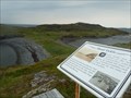
in Photos Then and Now Shoal Tickle is an abandoned community on Fogo Island, Newfoundland. Resettlement took place in the 1930s. It's one of four places in the immediate area that met a similar fate. posted by: Trail Blaisers location: Newfoundland and Labrador, Canada date approved: 07/23/2015 last visited: never |
 view gallery view galleryNW17.1 km |  Fogo, Newfoundland and Labrador - Population 982 Fogo, Newfoundland and Labrador - Population 982
in Population Signs The town of Fogo is found on Fogo Island which sticks out from Newfoundland into the North Atlantic Ocean. posted by: Trail Blaisers location: Newfoundland and Labrador, Canada date approved: 08/24/2017 last visited: never |
 view gallery view galleryNW17.2 km |  View of Fogo from East of Town - Fogo, Newfoundland and Labrador View of Fogo from East of Town - Fogo, Newfoundland and Labrador
in Cityscapes A dramatic spot to take in the town and its surroundings. posted by: Trail Blaisers location: Newfoundland and Labrador, Canada date approved: 08/23/2017 last visited: never |
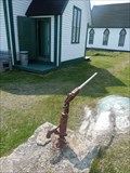 view gallery view galleryNW18.2 km |  Hand Operated Pump - Fogo, Newfoundland and Labrador Hand Operated Pump - Fogo, Newfoundland and Labrador
in Hand Operated Water Pumps You will find this hand operated pump on the grounds of the former one room school house, which is now a museum and registered heritage site. posted by: Trail Blaisers location: Newfoundland and Labrador, Canada date approved: 08/17/2015 last visited: never |
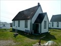 view gallery view galleryNW18.2 km |  Old School House - Fogo, Newfoundland and Labrador Old School House - Fogo, Newfoundland and Labrador
in Atlantic Canada Heritage Properties The Old Schoolhouse has historic value due to its age, its historical function, and its association with Fogo’s Roman Catholic Congregation, which operated the school from 1888 to 1969. It is now a museum. posted by: Trail Blaisers location: Newfoundland and Labrador, Canada date approved: 08/23/2017 last visited: never |
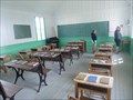 view gallery view galleryNW18.2 km |  One-Room Roman Catholic Schoolhouse - Fogo, Newfoundland and Labrador One-Room Roman Catholic Schoolhouse - Fogo, Newfoundland and Labrador
in One-Room Schoolhouses This one-room Roman Catholic schoolhouse is open as a museum in the summer months. It was open from 1888 until 1969. The building is a Registered Heritage Structure by The Province of Newfoundland and Labrador. posted by: Trail Blaisers location: Newfoundland and Labrador, Canada date approved: 08/17/2015 last visited: never |
 view gallery view galleryNW18.3 km | Fogo United Church - Fogo, Newfoundland and Labrador in Atlantic Canada Heritage Properties Fogo United Church was designated a Registered Heritage Structure by the Heritage Foundation of Newfoundland and Labrador in 1997. posted by: Trail Blaisers location: Newfoundland and Labrador, Canada date approved: 08/23/2017 last visited: never |
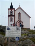 view gallery view galleryNW18.3 km |  Fogo United Church - Fogo, Newfoundland and Labrador Fogo United Church - Fogo, Newfoundland and Labrador
in Continental Reformed and Congregational Church Sites Fogo United Church was designated a Registered Heritage Structure by the Heritage Foundation of Newfoundland and Labrador in 1997. posted by: Trail Blaisers location: Newfoundland and Labrador, Canada date approved: 08/23/2017 last visited: never |
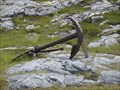 view gallery view galleryNW18.7 km |  Fogo Battery, Fogo Island, Newfoundalnd Fogo Battery, Fogo Island, Newfoundalnd
in Anchors Beautiful walking trail. Use caution - many areas are steep and rocky. Dress appropriately, take drinking water, and let someone know your itinerary. Leave nothing behind and take only your memories and photos. posted by:  castormalin7405 castormalin7405 location: Newfoundland and Labrador, Canada date approved: 03/30/2013 last visited: 07/10/2015 |
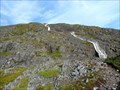 view gallery view galleryNW19 km |  Fogo Head Trail Staircase - Fogo, Newfoundland and Labrador Fogo Head Trail Staircase - Fogo, Newfoundland and Labrador
in Outdoor Stairways Your quads will be burning when you get to the top of this staircase. posted by: Trail Blaisers location: Newfoundland and Labrador, Canada date approved: 08/26/2017 last visited: never |
 view gallery view gallery W19.2 km W19.2 km
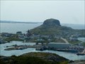
| Fogo Softball Diamond - Fogo, Newfoundland and Labrador in Amateur Baseball Fields Play some scrub at the foot of Brimstone Head. posted by: Trail Blaisers location: Newfoundland and Labrador, Canada date approved: 08/17/2015 last visited: never |
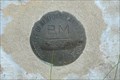
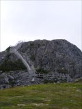 view gallery view galleryW19.5 km |  Hydrographic Service Canada 8909206 Hydrographic Service Canada 8909206
in Canadian Benchmarks Benchmark located above the town of Fogo at the peak of Brimstone head. posted by: 3Drifters location: Newfoundland and Labrador, Canada date approved: 07/13/2010 last visited: 07/07/2015 |
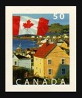 view gallery view galleryW50.7 km |  Durrell, Twillingate, Newfoundland Durrell, Twillingate, Newfoundland
in Philatelic Photographs A view of the small community of Durrell on South Twillingate Island, Newfoundland, appears on this 2004 Canadian postage stamp. posted by: hykesj location: Newfoundland and Labrador, Canada date approved: 04/08/2019 last visited: 05/29/2022 |
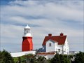 view gallery view galleryW54.2 km |  Long Point Lighthouse - North Twillingate Island, NL Long Point Lighthouse - North Twillingate Island, NL
in Coastal Lighthouses Long Point Lighthouse has been guiding mariners into Twillingate harbor since 1876. posted by: hykesj location: Newfoundland and Labrador, Canada date approved: 09/09/2023 last visited: never |
 view gallery view gallery S86.1 km S86.1 km
| Dover Hilltop in Canadian Benchmarks Found near the Dover Fault Observation Deck. posted by: GOTNL location: Newfoundland and Labrador, Canada date approved: 10/18/2014 last visited: 09/23/2018 |
 view gallery view gallery SW87.1 km SW87.1 km
|  Gander International Airport - Gander, Newfoundland and Labrador, Canada Gander International Airport - Gander, Newfoundland and Labrador, Canada
in Airports Gander International's heyday was in the 1940s to 1950s when it was a frequent stopover for planes needing to refuel between Europe and North America. It was also a major training ground during WWII. posted by: Trail Blaisers location: Newfoundland and Labrador, Canada date approved: 07/19/2015 last visited: never |
 view gallery view gallerySW87.1 km | Geodetic Survey Gander 76G0263 in Canadian Benchmarks Benchmark Disk in wall of Old Post Office building in Gander, NL. posted by: GOTNL location: Newfoundland and Labrador, Canada date approved: 10/02/2006 last visited: 07/18/2015 |
 view gallery view gallerySW87.2 km |  Inside Gander International Airport - Gander, Newfoundland and Labrador Inside Gander International Airport - Gander, Newfoundland and Labrador
in Inside Airports Gander was once one of the busiest layover locations in the world when flights between North America and Europe needed to refuel here. Today, connections will get you to locations around the province and Maritimes. posted by: Trail Blaisers location: Newfoundland and Labrador, Canada date approved: 07/19/2015 last visited: never |
 view gallery view gallerySW87.4 km |  Canadian Forces Base (9 Wing) Gander - Gander, Newfoundland and Labrador Canadian Forces Base (9 Wing) Gander - Gander, Newfoundland and Labrador
in Military Installations 9 Wing Gander was established in 1935. Once Canada went to war in 1939 it grew in importance. At one point, Winston Churchill referred to it as "the largest aircraft carrier in the North Atlantic". posted by: Trail Blaisers location: Newfoundland and Labrador, Canada date approved: 07/21/2019 last visited: never |
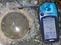 view gallery view gallerySW87.5 km | Geodetic Survey Gander 90F149 in Canadian Benchmarks Brass survey disk located near CFB Gander. posted by: GOTNL location: Newfoundland and Labrador, Canada date approved: 10/02/2006 last visited: 07/01/2007 |
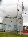 view gallery view gallerySW87.5 km |  Weather Radar - Gander, Newfoundland and Labrador Weather Radar - Gander, Newfoundland and Labrador
in Weather Radars This weather radar has been operational at Canadian Forces Base Gander since the summer of 1940. Gander was the most important launching point for Allied airplanes heading to/from Europe during WWII. posted by: Trail Blaisers location: Newfoundland and Labrador, Canada date approved: 07/21/2019 last visited: never |
 view gallery view gallerySW87.7 km | Geodetic Survey Gander 76G0256 in Canadian Benchmarks Benchmark Disk set in wall of the College of the North Atlantic Building in Gander, NL. posted by: GOTNL location: Newfoundland and Labrador, Canada date approved: 10/02/2006 last visited: never |
|