 view gallery view gallery NW5.6 km NW5.6 km
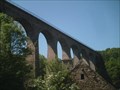
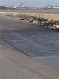
|   Viaduc de Fermanville - Fermanville, France Viaduc de Fermanville - Fermanville, France
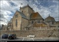
in Railroad Bridges Viaduc ferroviaire de la vallée des moulins, utilisé jusqu'en 1951 pour le passage du petit train de Cherbourg à Barfleur. posted by:  Rat Boudeur Rat Boudeur location: France date approved: 08/05/2008 last visited: 04/08/2015 |
 view gallery view gallery E8.5 km E8.5 km
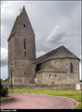
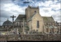
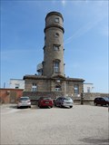
|  Église Sainte-Petronille / Church of Saint Petronilla (La Pernelle, Normandy) Église Sainte-Petronille / Church of Saint Petronilla (La Pernelle, Normandy)
in Monuments Historiques Français Small but beautiful stone Church of Saint Petronilla (Église Sainte-Petronille), located on a tiny hill in village La Pernelle, is from a far visible architectural dominant of this picturesque part of Cotentin Peninsula in Normandy... posted by:  Dorcadion Team Dorcadion Team location: Normandie, France date approved: 02/25/2010 last visited: 12/15/2014 |
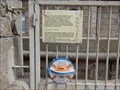
 view gallery view galleryE8.5 km |  Point géodésique 5039501 - L'église Sainte-Petronille (La Pernelle) Point géodésique 5039501 - L'église Sainte-Petronille (La Pernelle)
in French Benchmarks Point géodésique - sommet du clocher (L'église Sainte-Petronille). Geodetical point (LA PERNELLE I, 5039501) on the top of bell tower of Church of Saint Petronilla in La Pernelle (Normandy). posted by: Dorcadion Team location: Normandie, France date approved: 06/16/2014 last visited: 12/19/2014 |
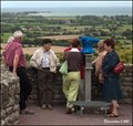 view gallery view galleryE8.7 km |  Monocular at Church of St. Petronilla in La Pernelle (Normandy) Monocular at Church of St. Petronilla in La Pernelle (Normandy)
in Coin-Op Binoculars One monocular at small platform close to Church of St. Petronilla (Église Sainte-Petronille) in La Pernelle offers great vistas over on the northeast coast of the Cotentin Peninsula in Normandy. posted by: Dorcadion Team location: Normandie, France date approved: 02/25/2010 last visited: 02/12/2012 |
 view gallery view gallery W10.8 km W10.8 km
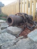
|  Les canons de la verrerie - La Glacerie, Basse-Normandie Les canons de la verrerie - La Glacerie, Basse-Normandie
in Static Artillery Displays [FR] Le canon enchainé
[EN] posted by: Tromel location: Normandie, France date approved: 12/18/2016 last visited: 11/23/2016 |
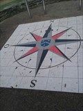 view gallery view galleryW11.4 km |  Rose des vents de la Verrerie - La Glacierie, Basse-Normandie Rose des vents de la Verrerie - La Glacierie, Basse-Normandie
in Compass Roses [FR] Rose des vents dans le parc de
[EN] Compass roses in the park of posted by: Tromel location: Normandie, France date approved: 12/19/2016 last visited: 11/23/2016 |
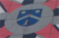 view gallery view galleryW11.4 km |  La Glacerie - La Glacerie, Basse-Normandie La Glacerie - La Glacerie, Basse-Normandie
in Coats of Arms [FR] Le blason de la ville de la Glacerie.
[EN] The coats of arms of the Glacerie city. posted by: Tromel location: Normandie, France date approved: 01/01/2017 last visited: 11/23/2016 |
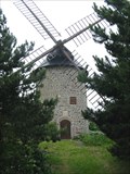 view gallery view gallery NE11.7 km NE11.7 km
|  Windmill in Gatteville, Barfleur, Normandie, France. Windmill in Gatteville, Barfleur, Normandie, France.
in Windmills Windmill in Gatteville, Barfleur, Normandie, France. This is the private mill of M. Leblanc who restaurated it. posted by: Barjon location: France date approved: 06/25/2007 last visited: 01/30/2023 |
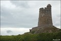 view gallery view gallery SE11.9 km SE11.9 km
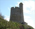
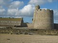
|  Fortifications of Vauban: Fort de la Hogue (Normandy, France) Fortifications of Vauban: Fort de la Hogue (Normandy, France)
in World Heritage Sites From a far visible tower of Fort de la Hogue - a landmark of Saint-Vaast-La-Hougue area - is one of 12 fortified objects designed by genial French military engineer Sébastien Le Prestre de Vauban, which were added to UNESCO WH List in 2008. posted by: Dorcadion Team location: Normandie, France date approved: 02/24/2010 last visited: 03/15/2021 |
 view gallery view gallerySE11.9 km |  Fort de La Hougue,Saint-Vaast-la-Hougue,France Fort de La Hougue,Saint-Vaast-la-Hougue,France
in Historic Forts Le Fort de La Hougue à Saint-Vaast-la-Hougue./La Hougue in Saint-Vaast-la-Hougue. posted by: celene37 location: Normandie, France date approved: 02/24/2018 last visited: 03/15/2021 |
 view gallery view galleryNE12.2 km | Point géodésique 5003001 - L'église Saint-Nicolas (Barfleur) in French Benchmarks Point géodésique - sommet du clocher (L'église Saint-Nicolas). Geodetical point (BARFLEUR I, 5003001) on the top of bell tower of Church of St. Nicolas in Barfleur (Normandy). posted by: Dorcadion Team location: Normandie, France date approved: 06/16/2014 last visited: 07/13/2018 |
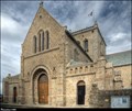 view gallery view galleryNE12.2 km | Eglise Saint-Nicolas / Church of St. Nicolas (Barfleur, Normandy) in Monuments Historiques Français Church of St. Nicolas (Eglise Saint-Nicolas) in Barfleur is the architectural dominant of this small pictoresque seaport in north of Cotentin peninsula (Normandy). posted by: Dorcadion Team location: Normandie, France date approved: 02/26/2010 last visited: 07/13/2018 |
 view gallery view galleryNE12.2 km |  Eglise Saint-Nicolas / Church of St. Nicolas (Barfleur, Normandy) Eglise Saint-Nicolas / Church of St. Nicolas (Barfleur, Normandy)
in This Old Church Church of St. Nicolas (Eglise Saint-Nicolas) in Barfleur, built in th first half 17th century, is the architectural dominant of this small pictoresque seaport in north of Cotentin peninsula (Normandy). posted by: Dorcadion Team location: Normandie, France date approved: 06/17/2014 last visited: 07/13/2018 |
 view gallery view galleryW12.9 km |  Rampe d'accès pour bateaux - Tourlaville, Basse-Normandie Rampe d'accès pour bateaux - Tourlaville, Basse-Normandie
in Boat Ramps [FR] Rampe d'accès pour bateaux.
[EN] Boat ramp in Tourlaville. posted by: Tromel location: Normandie, France date approved: 12/18/2016 last visited: 11/23/2016 |
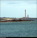
 view gallery view galleryNE13 km | Phare de Gatteville, France in Monuments Historiques Français the classified lighthouse is the small one.
le phare classé est le petit. posted by: sara et gege location: Normandie, France date approved: 11/02/2020 last visited: 07/23/2021 |
 view gallery view galleryNE13 km | ") le semaphore de Barfleur - Gatteville, France le semaphore de Barfleur - Gatteville, France
in Histoires de France (French historical markers) the semaphore is located behind the great Barfleur lighthouse.
le sémaphore est situé derriere le grand phare de Barfleur. posted by: sara et gege location: Normandie, France date approved: 11/02/2020 last visited: 07/23/2021 |
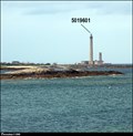 view gallery view galleryNE13.2 km | Point géodésique 5019601 - Phare de Gatteville (Gatteville-le-Phare) in French Benchmarks Point géodésique - sommet du phare (Phare de Gatteville). Geodetical point (GATTEVILLE-LE-PHARE I, 5019601) on the top of the Gatteville lighthouse in Gatteville-le-Phare (Normandy). posted by: Dorcadion Team location: Normandie, France date approved: 06/16/2014 last visited: 03/15/2021 |
 view gallery view galleryNE13.2 km |  Phare de Gatteville (Normandy) Phare de Gatteville (Normandy)
in Wikipedia Entries Phare de Gatteville, also known as Pointe de Barfleur Light, is an active lighthouse near Gatteville-le-Phare at the tip of Barfleur, Manche department, in the Lower Normandy region of France. posted by: Dorcadion Team location: Normandie, France date approved: 06/16/2014 last visited: 03/15/2021 |
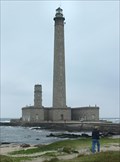 view gallery view galleryNE13.2 km |  Phare de Gatteville, Normandie, France. Phare de Gatteville, Normandie, France.
in Coastal Lighthouses Phare de Gatteville, Normandie, France. posted by: Barjon location: France date approved: 06/25/2007 last visited: 01/30/2023 |
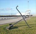 view gallery view galleryW13.4 km |  Ancre de Tourlaville - Tourlaville, Basse-Normandie Ancre de Tourlaville - Tourlaville, Basse-Normandie
in Anchors [FR] Belle ancre de marine sur le bord de la route
[EN] Beautifull anchor on the road side posted by: Tromel location: Normandie, France date approved: 12/11/2016 last visited: 02/11/2017 |
 view gallery view galleryE13.5 km | Fort de Tatihou,Saint-Vaast-la-Hougue,France in Historic Forts Le fort de Tatihou à Saint-Vaast-la-Hougue./ Fort Tatihou in Saint-Vaast-la-Hougue. posted by: celene37 location: Centre-Val-de-Loire, France date approved: 02/23/2018 last visited: 05/08/2017 |
 view gallery view galleryE13.5 km | Fort de Tatihou,Saint-Vaast-la-Hougue,France in World Heritage Sites Le fort de Tatihou à Saint-Vaast-la-Hougue./ Fort Tatihou in Saint-Vaast-la-Hougue. posted by: celene37 location: Normandie, France date approved: 02/24/2018 last visited: 01/30/2023 |
 view gallery view galleryE13.5 km |  Fort de Tatihou,Saint-Vaast-la-Hougue,France Fort de Tatihou,Saint-Vaast-la-Hougue,France
in Military Installations Le fort de Tatihou à Saint-Vaast-la-Hougue./ Fort Tatihou in Saint-Vaast-la-Hougue. posted by: celene37 location: Centre-Val-de-Loire, France date approved: 03/01/2018 last visited: 01/30/2023 |
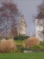 view gallery view galleryW14.3 km |  Themis - Cherbourg-en-Cotentin, Basse-Normandie Themis - Cherbourg-en-Cotentin, Basse-Normandie
in Epic Beings and Creatures [FR] Statue du dieu Themis à Cherbourg [EN] Statue of the goddess Themis posted by: Tromel location: Normandie, France date approved: 12/18/2016 last visited: 11/23/2016 |
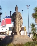 view gallery view galleryW14.5 km | Minerve - Cherbourg-en-Cotentin, Basse-Normandie in Epic Beings and Creatures [FR] Statue du dieu Minerve à Cherbourg
[EN] Statue of the goddess Minerva posted by: Tromel location: Normandie, France date approved: 12/11/2016 last visited: 08/25/2022 |
|