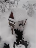
 view gallery view gallery E1.4 km E1.4 km
|   Studánka Kladnatá - Horní Becva, Czech Republic Studánka Kladnatá - Horní Becva, Czech Republic
in Natural Springs Studánka Kladnatá posted by:  puczmeloun puczmeloun location: Zlínský kraj, Czechia date approved: 03/09/2015 last visited: never |
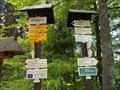 view gallery view gallery NW2.3 km NW2.3 km
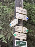
|  MARTINAK (PAM.), 785 m.n.m., Beskydy, Czech - Republic MARTINAK (PAM.), 785 m.n.m., Beskydy, Czech - Republic
in Direction and Distance Arrows Turistický rozcestník MARTINAK (PAM.) 785 m.n.m. v Beskydech posted by:  Berseg Berseg location: Zlínský kraj, Czechia date approved: 08/06/2013 last visited: 07/16/2014 |
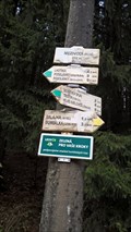
 view gallery view galleryNW2.6 km | BARINY, 815 m.n.m, Beskydy, Czech - Republic in Direction and Distance Arrows Turistický rozcestník BARINY 815 m.n.m. v Beskydech posted by: Berseg location: Zlínský kraj, Czechia date approved: 11/16/2013 last visited: never |
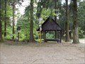
 view gallery view gallery SE2.9 km SE2.9 km
|  Kaple Cyrila a Metodeje, Bílá-Hlavatá, Czech Republic Kaple Cyrila a Metodeje, Bílá-Hlavatá, Czech Republic
in Waychapels Wooden chapelle on the road 56 in Beskydy mountains. posted by: Arne1 location: Moravskoslezský kraj, Czechia date approved: 02/28/2011 last visited: 07/07/2022 |
 view gallery view gallery S3.4 km S3.4 km
|  TB 4611-3 Kubiška TB 4611-3 Kubiška
in Czech Geodetic Points TB na hrebeni Vsetinskych vrchu, zapadne od Vysoke. posted by: haggaeus location: Zlínský kraj, Czechia date approved: 05/10/2011 last visited: never |
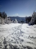
 view gallery view gallerySE3.5 km | Pramen Becvy in Natural Springs A spring under Vysoká mountain (1024m ASL) and the source of Roznovska Becva river. posted by: haggaeus location: Zlínský kraj, Czechia date approved: 05/10/2011 last visited: never |
 view gallery view gallerySE3.5 km | TB 3610-39 Vysoká in Czech Geodetic Points TB na nejvyssim vrcholu Vsetinskych vrchu, 1024m n.m. posted by: haggaeus location: Zlínský kraj, Czechia date approved: 05/10/2011 last visited: never |
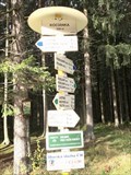 view gallery view gallery N3.9 km N3.9 km
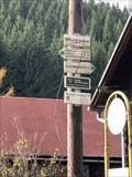
| KOCIÁNKA 628 m, Czech republic in Direction and Distance Arrows Turistický rozcestník na parkovišti Kociánka.. Tourist direction and distance arrows at the parking Kociánka. posted by: davidb11 location: Moravskoslezský kraj, Czechia date approved: 01/24/2020 last visited: 10/30/2021 |
 view gallery view galleryS4.2 km | ZhB 4611-212 Polana in Czech Geodetic Points ZhB na louce na jiznim svahu Polany. posted by: haggaeus location: Zlínský kraj, Czechia date approved: 02/12/2009 last visited: 02/20/2010 |
 view gallery view galleryN4.2 km | PODOLÁNKY (ROZC.) 629 m, Czech republic in Direction and Distance Arrows uristický rozcestník na rozcestí Podolánky. Tourist direction and distance arrows at the crossroads Podolánky posted by: davidb11 location: Moravskoslezský kraj, Czechia date approved: 01/24/2020 last visited: never |
 view gallery view galleryN4.7 km | PODOLÁNKY (JEDNOTA, BUS) 620 m, Czech republic in Direction and Distance Arrows Turistický rozcestník u autobusové tocny Podolánky. Tourist direction and distance arrows near the bus turntable Podolánky. posted by: davidb11 location: Moravskoslezský kraj, Czechia date approved: 01/24/2020 last visited: never |
 view gallery view galleryS4.8 km |  Milonova Belfry Milonova Belfry
in Bell Towers A wooden belfry under Milonova hill in Vsetinske Vrchy mountains. posted by: haggaeus location: Zlínský kraj, Czechia date approved: 05/09/2011 last visited: never |
 view gallery view galleryN4.8 km | PODOLÁNKY (H. SRDCE BESKYD) 680 m, Czech republic in Direction and Distance Arrows Turistický rozcestník u parkovište Podolánky. Tourist direction and distance arrows next to parking Podolánky. posted by: davidb11 location: Moravskoslezský kraj, Czechia date approved: 01/24/2020 last visited: 10/30/2021 |
 view gallery view gallery SW5 km SW5 km
| TB 3615-38 Pálenice in Czech Geodetic Points TB na hrebenovce Vsetinskych vrchu, kopec Kotlova, 868m n.m. Skutecny vrchol Palenice je kousek na jih odtud (je na nem zhuštovací bod 4611-209.1). posted by: haggaeus location: Zlínský kraj, Czechia date approved: 05/10/2011 last visited: 09/29/2012 |
 view gallery view galleryN5 km | PODOLÁNKY (ŠKOLA,BUS) 610 m, Czech republic in Direction and Distance Arrows Turistický rozcestník na rozcestí u školy v Podolánkách. Tourist direction and distance arrows at the crossroads near the school in Podolánky posted by: davidb11 location: Moravskoslezský kraj, Czechia date approved: 01/24/2020 last visited: never |
 view gallery view galleryE5.1 km |  Payphone / Telefonni automat - Bílá 134, Bílá, Czech Republic Payphone / Telefonni automat - Bílá 134, Bílá, Czech Republic
in Payphones Classical Telefonica 02 Czech payphone. posted by: davidb11 location: Moravskoslezský kraj, Czechia date approved: 11/10/2017 last visited: never |
 view gallery view gallery NE5.1 km NE5.1 km
|  Naucná stezka Paravýsadku Wolfram, Celadná, Czech republic Naucná stezka Paravýsadku Wolfram, Celadná, Czech republic
in Self Guided Walks and Trails Naucná stezka Paravýsadku Wolfram. Self Guides Parachuting plant Wolfram posted by: davidb11 location: Moravskoslezský kraj, Czechia date approved: 01/13/2020 last visited: never |
 view gallery view galleryE5.3 km | MEZIVODÍ (BUS) 602 m, Czech republic in Direction and Distance Arrows Turistický rozcestník ve Skiareálu Mezivodí.
Turist direction and distance arrows in Skiarea Mezivodí. posted by: davidb11 location: Moravskoslezský kraj, Czechia date approved: 11/11/2017 last visited: never |
 view gallery view gallerySE5.5 km |  No. 465. Rozhledna Sukenická, CZ No. 465. Rozhledna Sukenická, CZ
in Tourist Stamps Photos Turistická známka zobrazuje drevenou rozhlednu Sukenická na vrcholu Carták (953mnm) v Hostýnsko - vsetínské hornatine. /// Turist stamp showes wooden look tower Sukenická on the tof of Carták (953) in Hostýnsko - vsetínská hornatina. posted by: Ursus PiPa location: Moravskoslezský kraj, Czechia date approved: 08/29/2012 last visited: 07/07/2022 |
 view gallery view gallerySE5.6 km | TB 4606-2 Certak in Czech Geodetic Points Trigonometrický bod v Beskydech posted by: alicek location: Zlínský kraj, Czechia date approved: 08/08/2013 last visited: never |
 view gallery view gallerySE5.6 km |  Rozhledna Cartak / Sukenicka - Beskydy Mountain, Czech Republic Rozhledna Cartak / Sukenicka - Beskydy Mountain, Czech Republic
in Look-Out Towers [ENG] Look-out tower in Beskydy Mountain
[CZ] Nejmladší rozhledna v Beskydech posted by: RaďousCZ location: Zlínský kraj, Czechia date approved: 08/01/2010 last visited: 07/07/2022 |
 view gallery view galleryS5.6 km | TB 4611-10 Milonova in Czech Geodetic Points TB na vrcholu kopce Milonova, 845m n.m. posted by: haggaeus location: Zlínský kraj, Czechia date approved: 05/10/2011 last visited: never |
 view gallery view galleryN6 km |  Polana Polana
in Scenic Overlooks Polana is a crossroad of touristic ways with a nice overlook of the surrounding coutryside. posted by: Pechlati location: Moravskoslezský kraj, Czechia date approved: 02/22/2021 last visited: never |
 view gallery view gallerySW6.1 km | TB 3615-37 Na strunžiskách in Czech Geodetic Points TB na hrebeni Vsetinskych vrchu. posted by: haggaeus location: Zlínský kraj, Czechia date approved: 05/10/2011 last visited: 09/29/2012 |
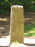 view gallery view gallerySE6.3 km |  Trojacka - tripoint boundary marker Trojacka - tripoint boundary marker
in European Historic Survey Stones, Monuments and Benchmarks A historical boundary stone in the Beskydy mountains. posted by: Anneke location: Moravskoslezský kraj, Czechia date approved: 12/31/2010 last visited: never |
|