 view gallery view gallery S12.2 km S12.2 km
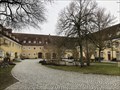
|   Kloster Strahlfeld - Roding, Bayern, Gemany Kloster Strahlfeld - Roding, Bayern, Gemany
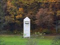
in Wikipedia Entries Kloster St. Dominikus in Strahlfeld
***
Kloster St. Dominikus in Strahlfeld - Bavaria. posted by:  Tintenklexx Tintenklexx location: Bayern, Germany date approved: 03/25/2018 last visited: never |
 view gallery view gallery SW16.7 km SW16.7 km
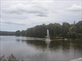
|  Jet dèau in Bodenwöhr/ Bayern/ Deutschland Jet dèau in Bodenwöhr/ Bayern/ Deutschland
in Fountains This giant fountain gushing from the south end of lake Hammerweiher is the symbol of the town Bodenwöhr, Germany. posted by: *Team Krombaer* location: Bayern, Germany date approved: 09/12/2014 last visited: 03/14/2016 |
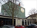 view gallery view gallerySW17.1 km |  Brauerei Jacob - Bodenwöhr, Opf / Deutschland Brauerei Jacob - Bodenwöhr, Opf / Deutschland
in Breweries [D] Privatbrauerei Jacob am Hammersee in Bodenwöhr, Deutschland.
[EN] Private brewery in Upper Palatinate, Germany. posted by: *Team Krombaer* location: Bayern, Germany date approved: 01/08/2022 last visited: 06/10/2022 |
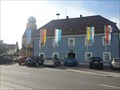 view gallery view gallerySW17.1 km |  Halt' die Fahne in den Wind... - Rathaus Bodenwöhr/ Deutschland Halt' die Fahne in den Wind... - Rathaus Bodenwöhr/ Deutschland
in Municipal Flags In front of the townhall in Bodenwöhr, Germany, Bayern stand some flags - one of them is the municipal flag of Bodenwöhr. posted by: *Team Krombaer* location: Bayern, Germany date approved: 09/13/2014 last visited: 03/14/2016 |
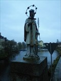 view gallery view gallery SE18.7 km SE18.7 km
|  St. John of Nepomuk - 92413 Cham/Germany/BY St. John of Nepomuk - 92413 Cham/Germany/BY
in Statues of Religious Figures The statue of St. John of Nepomuk in centre of Cham, Germany, BY posted by: *Team Krombaer* location: Bayern, Germany date approved: 11/11/2016 last visited: never |
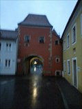 view gallery view gallerySE18.7 km |  Biertor - 93413 Cham /BY/Deutschland Biertor - 93413 Cham /BY/Deutschland
in Satellite Imagery Oddities So-called "Biertor" in Cham, Germany posted by: *Team Krombaer* location: Bayern, Germany date approved: 02/19/2017 last visited: never |
 view gallery view gallerySE18.7 km |  Biertor - 93413 Cham - BY - Deutschland Biertor - 93413 Cham - BY - Deutschland
in Deutsche Denkmallisten - German Monument Registers So-called "Biertor" in Cham, Germany posted by: *Team Krombaer* location: Bayern, Germany date approved: 11/07/2016 last visited: 03/20/2023 |
 view gallery view gallerySE18.8 km | Turbinenhaus der Stadtwerke - 93413 Cham/Deutschland/BY in Deutsche Denkmallisten - German Monument Registers [D] Turbinenhaus des Städtischen Elektrizitätswerks [EN] Historic-protected power-plant house in the city of Cham posted by: *Team Krombaer* location: Bayern, Germany date approved: 11/08/2016 last visited: never |
 view gallery view gallerySE18.8 km |  Elektrizitätswerk - Classic German Game - Cham/Germany/BY Elektrizitätswerk - Classic German Game - Cham/Germany/BY
in Monopoly in the Real World The historic-protected Electricity Plant in Cham, Germany posted by: *Team Krombaer* location: Bayern, Germany date approved: 11/08/2016 last visited: never |
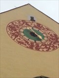 view gallery view gallerySE19 km |  Signs of zodiac - Clock of the townhall - 93416 Cham/BY/Germany Signs of zodiac - Clock of the townhall - 93416 Cham/BY/Germany
in Signs of Zodiac In a height abbot 10 meters is that townclock with signs of zodiac posted by: *Team Krombaer* location: Bayern, Germany date approved: 11/07/2016 last visited: 06/16/2023 |
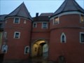
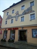 view gallery view gallerySE19 km | Bürgerhaus am Marktplatz - 93413 Cham/Deutschland/BY in Deutsche Denkmallisten - German Monument Registers [D]Denkmalgeschütztes Bürgerhaus am Marktplatz Cham //
[EN] Historic-protected Mansionhouse in Cham posted by: *Team Krombaer* location: Bayern, Germany date approved: 11/08/2016 last visited: 06/16/2023 |
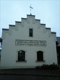
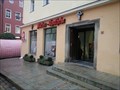 view gallery view gallerySE19 km |  Marien-Apotheke - Cham/Germany/BY Marien-Apotheke - Cham/Germany/BY
in Independent Pharmacies Independent pharmacy in Cham, Germany posted by: *Team Krombaer* location: Bayern, Germany date approved: 11/08/2016 last visited: 06/16/2023 |
 view gallery view gallery NE19.3 km NE19.3 km
|  TB 1914-34 U Dianina Dvora, Rybník (DO) TB 1914-34 U Dianina Dvora, Rybník (DO)
in Czech Geodetic Points TB 1914-34.0 je na nejvyšším bodu, je 800 m na severovýchod od Dianina Dvora. posted by:  torfik torfik location: Plzeňský kraj, Czechia date approved: 08/20/2013 last visited: 08/19/2018 |
 view gallery view galleryS19.6 km |  Trafotower at the outskirt of Roding - BY / Germany Trafotower at the outskirt of Roding - BY / Germany
in Historic Transformer Sub-Stations Buildings Simple, plastered trafotower off the villages posted by: Iris & Harry location: Bayern, Germany date approved: 11/09/2016 last visited: never |
 view gallery view galleryNE20.1 km | TB 1915-29 Kremencova skala in Czech Geodetic Points Trigonometrický bod v Ceském lese posted by: pavlikVB location: Plzeňský kraj, Czechia date approved: 10/02/2012 last visited: never |
 view gallery view galleryNE20.3 km | TB 1915-11 Herstejn in Czech Geodetic Points Trigonometrický bod v Ceském lese posted by: pavlikVB location: Plzeňský kraj, Czechia date approved: 10/02/2012 last visited: never |
 view gallery view gallery E20.3 km E20.3 km
| TB 2811-6 U trí znaku (DO) in Czech Geodetic Points Triangulacní bod je na nejvyšším míste zalesnené kupy (907 mnm) poblíž Ceské státní hranice. posted by: Arogant location: Plzeňský kraj, Czechia date approved: 02/08/2012 last visited: never |
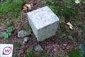
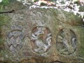 view gallery view galleryE20.4 km |  Drei Wappen, Bayern, DE, EU Drei Wappen, Bayern, DE, EU
in European Historic Survey Stones, Monuments and Benchmarks Historic Three Borders (Dreieckmark). The place where the borders meet posted by: Arogant location: Bayern, Germany date approved: 10/12/2011 last visited: 09/13/2013 |
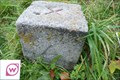
 view gallery view galleryE20.4 km |  Drei Wappen - Nr 19., Bayern, DE, EU Drei Wappen - Nr 19., Bayern, DE, EU
in Public Land Survey Marks Historic Three Borders (Dreieckmark). The place where the borders meet. posted by: Arogant location: Bayern, Germany date approved: 10/13/2011 last visited: 09/06/2013 |
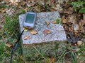
 view gallery view galleryE20.4 km |  Drei Wappen, Bayern, DE, EU Drei Wappen, Bayern, DE, EU
in Tripoints and Multipoints Historic Three Borders (Dreieckmark). The place where the borders meet. posted by: Arogant location: Bayern, Germany date approved: 03/13/2012 last visited: 09/13/2013 |
 view gallery view galleryE20.4 km |  DE - CZ, Drei Wappen, Bayern, DE, EU DE - CZ, Drei Wappen, Bayern, DE, EU
in Border Crossings CZ and DE border in mountain Czech forest. posted by: Arogant location: Bayern, Germany date approved: 10/12/2011 last visited: 09/13/2013 |
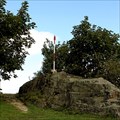
 view gallery view galleryE20.6 km | TB 2811-04 Cerchov, Pec (DO) in Czech Geodetic Points Bod je na nejvyssim vrcholu horskeho hrebenu na vycnivajici skalce na Cerchove,, ktery je nejvyssim vrcholem Ceskeho lesa. posted by: 3am location: Plzeňský kraj, Czechia date approved: 09/19/2010 last visited: 07/30/2015 |
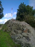
 view gallery view galleryE20.6 km |  Cerchov, 1042m. n. m - 3 419ft Cerchov, 1042m. n. m - 3 419ft
in Mountain Summits Nejvyšší vrchol Ceského lesa. The highest peak of the Bohemian Forest. posted by: Arogant location: Plzeňský kraj, Czechia date approved: 10/10/2010 last visited: 07/30/2015 |
 view gallery view galleryE20.6 km |  Cerchov 1042 m n. m. - nejvyšší bod okresu Domažlice Cerchov 1042 m n. m. - nejvyšší bod okresu Domažlice
in Geographic High Points Nejvyšší bod okresu Domažlice.
High Point district Domažlice. posted by: mirotiro location: Plzeňský kraj, Czechia date approved: 03/26/2011 last visited: 07/30/2015 |
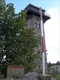
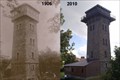 view gallery view galleryE20.6 km |  Photo lookout Cerchov 1906 and 2010, Czech Republic, EU Photo lookout Cerchov 1906 and 2010, Czech Republic, EU
in Photos Then and Now Lookout Cerchov 1042 meters above sea level, photographed in 1906 and 2010. posted by: 3am location: Plzeňský kraj, Czechia date approved: 09/19/2010 last visited: 08/19/2022 |
|