 view gallery view gallery W4.7 km W4.7 km
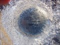
|   Benchmark 103-66 - Ignace, ON Benchmark 103-66 - Ignace, ON
in Canadian Benchmarks Ontario Department of Highways benchmark located on the east side of highway 17 outside of Ignace, ON. posted by:  jiggs11 jiggs11 location: Ontario, Canada date approved: 09/16/2020 last visited: never |
 view gallery view gallery NW23.8 km NW23.8 km
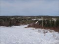
|  Tower Hill Tower Hill
in Scenic Roadside Look-Outs A scenic look-out overlooking the town of Ignace posted by: PM8 location: Ontario, Canada date approved: 04/06/2015 last visited: never |
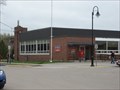
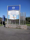
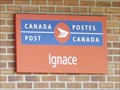 view gallery view galleryNW26.7 km |  Ignace ON P0T 1T0 Ignace ON P0T 1T0
in Canada Post Offices This Post Office is on Beaver Street at West Street which is just 180 metres south of the Trans Canada Highway (Hwy 17) in Ignace, Ontario. posted by: PeterNoG location: Ontario, Canada date approved: 07/22/2012 last visited: 07/13/2012 |
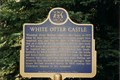 view gallery view galleryW44.9 km |  'WHITE OTTER CASTLE" - White Otter Lake, ON 'WHITE OTTER CASTLE" - White Otter Lake, ON
in Ontario Provincial Plaques The castle on White Otter Lake built by Jimmy McOuat and completed in 1915. posted by: graylling location: Ontario, Canada date approved: 10/27/2008 last visited: 12/27/2019 |
 W46.5 km |  Rora Site Rora Site
in Free Campsites Beautiful tent site on White Otter Lake, long sand beach, flat ground and great wind protection. posted by: Cachtons location: Ontario, Canada date approved: 08/14/2011 last visited: never |
 view gallery view gallery S65.2 km S65.2 km
| Atikokan Main Post Office P0T 1C0, Atikokan, ON in Canada Post Offices This post office is located next door to the Atitkokan Centennial Museum. posted by:  wildernessmama wildernessmama location: Ontario, Canada date approved: 06/01/2013 last visited: never |
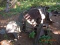
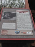 view gallery view galleryS65.3 km |  Atikokan Mine Marker and Cart – Atikokan, ON Atikokan Mine Marker and Cart – Atikokan, ON
in Signs of History Mining has always been an important part of Atikokan’s history, so it is fitting to have this mine cart and historical marker here in this small park in the middle of town. posted by: wildernessmama location: Ontario, Canada date approved: 06/05/2013 last visited: 08/13/2013 |
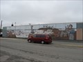
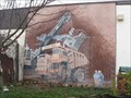 view gallery view galleryS65.3 km |  The Lectra Haul – Atikokan, ON The Lectra Haul – Atikokan, ON
in Murals The Lectra Haul was done by Heather Schmutzer in 1991 and depicts a scene from early mining days in Atikokan. posted by: wildernessmama location: Ontario, Canada date approved: 06/28/2013 last visited: never |
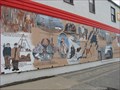
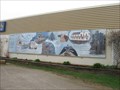 view gallery view galleryS65.3 km | Atikokan – Atikokan, ON in Murals Atikokan is a collection of scenes from this early days of this community. posted by: wildernessmama location: Ontario, Canada date approved: 06/28/2013 last visited: 08/13/2013 |
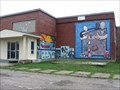
 view gallery view galleryS65.3 km | Lake Movers – Atikokan, ON in Murals Lake Movers by Heather Schmutzer was done in 1992 to portray a part of the mining history. posted by: wildernessmama location: Ontario, Canada date approved: 06/28/2013 last visited: never |
 view gallery view galleryS65.3 km | The Cutting Edge - Atikokan, ON in Murals This historical mural was created by the students of a local art teacher, who researched the background and illustrated the events on this wall in downtown Atikokan. posted by: wildernessmama location: Ontario, Canada date approved: 06/28/2013 last visited: never |
 view gallery view galleryS65.5 km | Art School Collection – Atikokan, ON in Murals These brightly colored murals are located on the exterior walls of the Atikokan Art School. posted by: wildernessmama location: Ontario, Canada date approved: 06/28/2013 last visited: never |
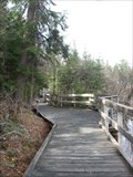 view gallery view galleryS72.6 km |  Barrier-Free Boardwalk - French Lake, ON Barrier-Free Boardwalk - French Lake, ON
in Non-Coastal Boardwalks This 1 km (.6 mile) boardwalk runs from the Dawson Trail Visitor Center to the beach on French Lake. posted by: wildernessmama location: Ontario, Canada date approved: 06/02/2013 last visited: never |
 view gallery view gallery SE72.6 km SE72.6 km
| Inwood Park--------camping and fun in Campgrounds A park I visit.
camping/Rv park,,play ground ,,beach ,,,dock,,brook trout lake ,100'+ lots
with bbq stands..$12/night.......pic of the sign or you in the park.
posted by: mmgg1970 location: Ontario, Canada date approved: 08/19/2009 last visited: 08/05/2011 |
 view gallery view galleryS72.9 km | French Portage Plaque – French Lake, ON in Ontario Provincial Plaques This Ontario Provincial Plaque is found in the Dawson Trail Campground at French Lake. posted by: wildernessmama location: Ontario, Canada date approved: 05/30/2013 last visited: never |
 view gallery view gallerySE81.4 km |  Arctic Watershed, Atikokan, ON Arctic Watershed, Atikokan, ON
in Elevation Signs This Arctic Watershed sign lists the elevation as 1660 feet above sea level. posted by: wildernessmama location: Ontario, Canada date approved: 05/28/2013 last visited: never |
NW102.7 km |  allmost home allmost home
in Plane Crash Sites the remains of the a/c have been laying on the shore of Kenneally lake for meny years. posted by: norton750 location: Ontario, Canada date approved: 10/29/2006 last visited: 10/30/2006 |
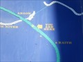 view gallery view gallerySE105.3 km |  You Are Here - First Trans Canada Route - Hwy 17, Raith ON You Are Here - First Trans Canada Route - Hwy 17, Raith ON
in 'You Are Here' Maps You Are Here on a large map of Northern Ontario at the Eastern/Central Time dividing point on the Trans Canada Highway. posted by: jiggs11 location: Ontario, Canada date approved: 09/15/2020 last visited: 09/26/2022 |
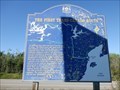 view gallery view gallerySE105.3 km | The First Trans-Canada Route - Raith, ON in Signs of History Large marker indicating the history of the first water routes to the west through northern Ontario posted by: jiggs11 location: Ontario, Canada date approved: 09/15/2020 last visited: 09/26/2022 |
 view gallery view gallerySE105.3 km |  90 Degrees West - Eastern/Central Time Zone - Trans Canada Highway 17 - Argon, ON 90 Degrees West - Eastern/Central Time Zone - Trans Canada Highway 17 - Argon, ON
in Permanent Geographic Coordinates Large Marker indicating the line between the Eastern and Central Time Zones. posted by: jiggs11 location: Ontario, Canada date approved: 09/17/2020 last visited: 09/26/2022 |
 view gallery view gallery NE113.5 km NE113.5 km
|  River Roads Mall - Jennings, Missouri River Roads Mall - Jennings, Missouri
in Indoor Malls River Roads Mall was an enclosed shopping mall in Jennings, Missouri of the suburb of St. Louis posted by: Dwaynep2010 location: none listed yet date approved: 01/24/2014 last visited: 01/20/2014 |
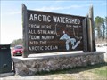
 view gallery view gallerySE116.5 km |  Arctic Ocean/Atlantic Ocean Watersheds - Hwy 17 ON Arctic Ocean/Atlantic Ocean Watersheds - Hwy 17 ON
in Watershed Markers and Monuments Two-sided marker on the Trans Canada Highway defining the Arctic Ocean and Atlantic Ocean Watersheds, located on the Trans Canada Highway about 30 miles north of Kakabeka Falls, ON posted by: jiggs11 location: Ontario, Canada date approved: 09/15/2020 last visited: 06/01/2023 |
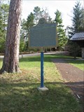
 view gallery view gallerySE116.5 km | "THE ARCTIC WATERSHED" - Hwy 17 Raith, ON in Ontario Provincial Plaques Ontario Provincial Plaque located at the division of the Arctic and Atlantic Watersheds in Northern Ontario, just south of the village of Raith. posted by: jiggs11 location: Ontario, Canada date approved: 09/14/2020 last visited: 06/01/2023 |
 view gallery view galleryS127.8 km |  BWCAW Oldsmobile BWCAW Oldsmobile
in Abandoned Dead Vehicles An abandoned Oldsmobile in Quetico Provincial Park. posted by: toponym location: Ontario, Canada date approved: 08/17/2012 last visited: 09/20/2017 |
 view gallery view galleryS131.3 km |  Chik Wauk Museum – Grand Marais, MN Chik Wauk Museum – Grand Marais, MN
in History Museums The Chik Wauk Museum officially opened to the public in July 2010, to share with visitors the rich history of the Gunflint area. posted by: wildernessmama location: Minnesota date approved: 10/11/2011 last visited: never |
|