 view gallery view gallery N8.2 km N8.2 km
|   Drei Wappen - Nr 19., Bayern, DE, EU Drei Wappen - Nr 19., Bayern, DE, EU
in Public Land Survey Marks Historic Three Borders (Dreieckmark). The place where the borders meet. posted by:  Arogant Arogant location: Bayern, Germany date approved: 10/13/2011 last visited: 09/06/2013 |
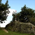
 view gallery view galleryN8.2 km |  Drei Wappen, Bayern, DE, EU Drei Wappen, Bayern, DE, EU
in Tripoints and Multipoints Historic Three Borders (Dreieckmark). The place where the borders meet. posted by: Arogant location: Bayern, Germany date approved: 03/13/2012 last visited: 09/13/2013 |
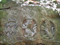 view gallery view galleryN8.2 km |  Drei Wappen, Bayern, DE, EU Drei Wappen, Bayern, DE, EU
in European Historic Survey Stones, Monuments and Benchmarks Historic Three Borders (Dreieckmark). The place where the borders meet posted by: Arogant location: Bayern, Germany date approved: 10/12/2011 last visited: 09/13/2013 |
 view gallery view galleryN8.2 km |  DE - CZ, Drei Wappen, Bayern, DE, EU DE - CZ, Drei Wappen, Bayern, DE, EU
in Border Crossings CZ and DE border in mountain Czech forest. posted by: Arogant location: Bayern, Germany date approved: 10/12/2011 last visited: 09/13/2013 |
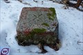
 view gallery view galleryN8.4 km |  TB 2811-6 U trí znaku (DO) TB 2811-6 U trí znaku (DO)
in Czech Geodetic Points Triangulacní bod je na nejvyšším míste zalesnené kupy (907 mnm) poblíž Ceské státní hranice. posted by: Arogant location: Plzeňský kraj, Czechia date approved: 02/08/2012 last visited: never |
 view gallery view galleryN8.5 km | TB 2811-5 U lesa in Czech Geodetic Points Trigonometrický bod na úbocí hory Cerchov posted by: pavlikVB location: Plzeňský kraj, Czechia date approved: 02/08/2012 last visited: never |
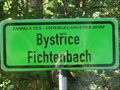 view gallery view galleryN9 km |  Bystrice - Fichtenbach, Ceský les, DO, CZ, EU Bystrice - Fichtenbach, Ceský les, DO, CZ, EU
in Ghost Towns Ghost village near Czech-Germany border. posted by: Arogant location: Plzeňský kraj, Czechia date approved: 10/19/2011 last visited: 08/03/2009 |
 view gallery view galleryN10.3 km |  No.1016, Ceska studanka - Cerchov, CZ No.1016, Ceska studanka - Cerchov, CZ
in Tourist Stamps Photos CS: Ceská studánka je silný pramen vyverající na úbocí hory Cerchov ve výšce 730m n.m. / EN: Bohemain spring is the abundant source on the mountainside of the mountain Cerchov at an altitude of 730 meters. posted by: pavlikVB location: Plzeňský kraj, Czechia date approved: 02/09/2012 last visited: 08/20/2022 |
 view gallery view gallery E10.5 km E10.5 km
|  Bank am Jakobsweg - Neukirchen beim heiligen Blut, Bayern, Germany Bank am Jakobsweg - Neukirchen beim heiligen Blut, Bayern, Germany
in Way of St. James --- Bench at Neukirchen beim heiligen Blut (Eastern-Bavarian-Way of St. James) --- Bank am Ostbayrischen Jakobsweg bei Neukirchen beim heiligen Blut posted by: Windego1 location: Bayern, Germany date approved: 03/09/2014 last visited: never |
 view gallery view galleryE10.8 km | Zweite Bank am Jakobsweg - Neukirchen beim heiligen Blut, Bayern, Germany in Way of St. James --- Bench at Neukirchen beim heiligen Blut (Eastern-Bavarian-Way of St. James) --- Bank am Ostbayrischen Jakobsweg bei Neukirchen beim heiligen Blut posted by: Windego1 location: Bayern, Germany date approved: 03/11/2014 last visited: never |
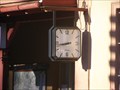 view gallery view galleryN11.6 km |  Hodiny - žst. Ceská Kubice, DO, CZ, EU Hodiny - žst. Ceská Kubice, DO, CZ, EU
in Town Clocks The clock at the railway station Ceska Kubice. posted by: Arogant location: Plzeňský kraj, Czechia date approved: 10/22/2011 last visited: never |
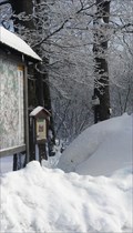
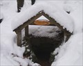 view gallery view galleryN12.2 km |  Wrbatova studánka Wrbatova studánka
in Natural Springs Spring under Cerchov mountain. posted by: haggaeus location: Plzeňský kraj, Czechia date approved: 01/31/2011 last visited: never |
 view gallery view galleryN12.2 km | No. 341, Kurzova vež - Cerchov, CZ in Tourist Stamps Photos Kurz´s Tower on top of Cerchov hill. posted by: Arogant location: Plzeňský kraj, Czechia date approved: 10/23/2011 last visited: 08/19/2022 |
 view gallery view galleryN12.2 km |  Josef Pavlista memorial Josef Pavlista memorial
in Specific Veteran Memorials no description yet posted by:  mirotiro mirotiro location: Plzeňský kraj, Czechia date approved: 09/25/2010 last visited: 07/30/2015 |
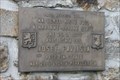
 view gallery view galleryN12.2 km |  Vilém Kurz, Cerchov, DO, CZ, EU Vilém Kurz, Cerchov, DO, CZ, EU
in Citizen Memorials Memorial table on top of the Cerchov hill. posted by: Arogant location: Plzeňský kraj, Czechia date approved: 02/13/2012 last visited: 08/11/2013 |
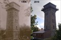 view gallery view galleryN12.2 km |  Photo lookout Cerchov 1906 and 2010, Czech Republic, EU Photo lookout Cerchov 1906 and 2010, Czech Republic, EU
in Photos Then and Now Lookout Cerchov 1042 meters above sea level, photographed in 1906 and 2010. posted by: 3am location: Plzeňský kraj, Czechia date approved: 09/19/2010 last visited: 08/19/2022 |
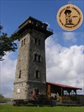
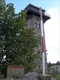
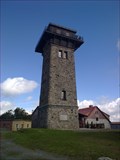 view gallery view galleryN12.2 km |  Rozhledna Cerchov, Czech Republic, EU Rozhledna Cerchov, Czech Republic, EU
in Look-Out Towers Cerchov Lookout is on the top of the Cesky les. Cerchov peak elevation is 1041 meters above sea level. posted by: 3am location: Plzeňský kraj, Czechia date approved: 09/20/2010 last visited: 08/19/2022 |
 view gallery view galleryN12.2 km | TB 2811-04 Cerchov, Pec (DO) in Czech Geodetic Points Bod je na nejvyssim vrcholu horskeho hrebenu na vycnivajici skalce na Cerchove,, ktery je nejvyssim vrcholem Ceskeho lesa. posted by: 3am location: Plzeňský kraj, Czechia date approved: 09/19/2010 last visited: 07/30/2015 |
 view gallery view galleryN12.2 km |  Cerchov 1042 m n. m. - nejvyšší bod okresu Domažlice Cerchov 1042 m n. m. - nejvyšší bod okresu Domažlice
in Geographic High Points Nejvyšší bod okresu Domažlice.
High Point district Domažlice. posted by: mirotiro location: Plzeňský kraj, Czechia date approved: 03/26/2011 last visited: 07/30/2015 |
 view gallery view galleryN12.2 km |  Cerchov, 1042m. n. m - 3 419ft Cerchov, 1042m. n. m - 3 419ft
in Mountain Summits Nejvyšší vrchol Ceského lesa. The highest peak of the Bohemian Forest. posted by: Arogant location: Plzeňský kraj, Czechia date approved: 10/10/2010 last visited: 07/30/2015 |
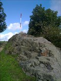
 view gallery view galleryN12.4 km |  Cerchov - Signpost Cerchov - Signpost
in Direction and Distance Arrows On top Cerchov posted by: nunca007 location: Plzeňský kraj, Czechia date approved: 02/12/2012 last visited: 02/11/2013 |
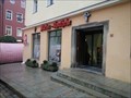 view gallery view gallery SW12.6 km SW12.6 km
|  Marien-Apotheke - Cham/Germany/BY Marien-Apotheke - Cham/Germany/BY
in Independent Pharmacies Independent pharmacy in Cham, Germany posted by: *Team Krombaer* location: Bayern, Germany date approved: 11/08/2016 last visited: 06/16/2023 |
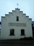
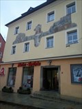 view gallery view gallerySW12.6 km |  Bürgerhaus am Marktplatz - 93413 Cham/Deutschland/BY Bürgerhaus am Marktplatz - 93413 Cham/Deutschland/BY
in Deutsche Denkmallisten - German Monument Registers [D]Denkmalgeschütztes Bürgerhaus am Marktplatz Cham //
[EN] Historic-protected Mansionhouse in Cham posted by: *Team Krombaer* location: Bayern, Germany date approved: 11/08/2016 last visited: 06/16/2023 |
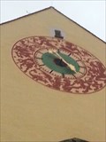 view gallery view gallerySW12.6 km |  Signs of zodiac - Clock of the townhall - 93416 Cham/BY/Germany Signs of zodiac - Clock of the townhall - 93416 Cham/BY/Germany
in Signs of Zodiac In a height abbot 10 meters is that townclock with signs of zodiac posted by: *Team Krombaer* location: Bayern, Germany date approved: 11/07/2016 last visited: 06/16/2023 |
 view gallery view gallerySW12.9 km |  Elektrizitätswerk - Classic German Game - Cham/Germany/BY Elektrizitätswerk - Classic German Game - Cham/Germany/BY
in Monopoly in the Real World The historic-protected Electricity Plant in Cham, Germany posted by: *Team Krombaer* location: Bayern, Germany date approved: 11/08/2016 last visited: never |
|