 view gallery view gallery NE3.4 km NE3.4 km
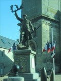
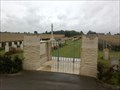
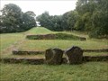
|   Memorial to WWI and WWII, Creully, France Memorial to WWI and WWII, Creully, France
in Non-Specific Veteran Memorials This memorial was first dedicated to the fallen in World War I, but another plaque was added later, for the fallen from World War II. posted by:  Queens Blessing Queens Blessing location: France date approved: 11/03/2014 last visited: 11/16/2014 |
 view gallery view gallery SE4.5 km SE4.5 km
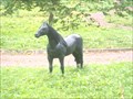
|  Le cheval noir - Secqueville en bessin - France Le cheval noir - Secqueville en bessin - France
in Fiberglass Horses Seul dans une prairie un magnifique cheval noir en fibre de verre.
Alone in a meadow a magnificent black horse in fiberglass. posted by: Alfouine location: Normandie, France date approved: 08/03/2017 last visited: 07/24/2022 |
 view gallery view gallery E4.8 km E4.8 km
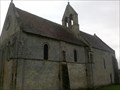
|  Église Saint-Martin du Cainet du Fresne-Camilly, France Église Saint-Martin du Cainet du Fresne-Camilly, France
in This Old Church L'église Saint-Martin du Cainet est une église catholique située au Fresne-Camilly.
The Church of St. Martin Cabinet is a Catholic church located in Fresne-Camilly. posted by: Alfouine location: Normandie, France date approved: 11/07/2016 last visited: 03/06/2019 |
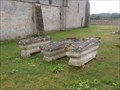 view gallery view galleryE4.8 km |  La nécropole médiévale du Cainet, France La nécropole médiévale du Cainet, France
in Churchyard Cemeteries La nécropole médiévale de l'église de Saint Martin du Cainet.
The medieval cemetery of the Church of Saint Martin's of Cainet. posted by: Alfouine location: Normandie, France date approved: 11/06/2016 last visited: 06/06/2021 |
 view gallery view galleryE4.8 km |  Église Saint-Martin du Cainet du Fresne-Camilly, France Église Saint-Martin du Cainet du Fresne-Camilly, France
in Wikipedia Entries L'église Saint-Martin du Cainet est une église catholique située au Fresne-Camilly.
The Church of St. Martin Cabinet is a Catholic church located in Fresne-Camilly. posted by: Alfouine location: Normandie, France date approved: 11/07/2016 last visited: 03/06/2019 |
 view gallery view galleryE4.8 km |  Église Saint-Martin du Cainet du Fresne-Camilly Église Saint-Martin du Cainet du Fresne-Camilly
in Monuments Historiques Français L'église Saint-Martin du Cainet est une église catholique située au Fresne-Camilly.
The Church of St. Martin Cabinet is a Catholic church located in Fresne-Camilly. posted by: Alfouine location: Normandie, France date approved: 11/06/2016 last visited: 03/06/2019 |
 view gallery view gallerySE5.8 km |  Le cimetière de sequeville en Bessin - France Le cimetière de sequeville en Bessin - France
in Veteran Cemeteries Au cimetière militaire britannique de Secqueville-en-Bessin reposent 117 soldats tombés lors de la bataille de Normandie.
At the British military cemetery in Secqueville-en-Bessin, 117 soldiers fell during the Battle of Normandy. posted by: Alfouine location: Normandie, France date approved: 08/02/2017 last visited: 04/19/2023 |
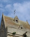 view gallery view gallery N6.1 km N6.1 km
|  Benchmark 14196A - Crépon, Basse-Normandie, France Benchmark 14196A - Crépon, Basse-Normandie, France
in French Benchmarks Benchmark au sommet de l'église. posted by: Trail Blaisers location: Normandie, France date approved: 07/31/2015 last visited: 04/05/2016 |
 view gallery view galleryNE6.1 km | Menhir des Demoiselles - Colombiers-sur-Seulles - France in Wikipedia Entries Le menhir des Demoiselles ou de la Pierre Debout est un menhir situé au lieu-dit la Pierre.
The menhir of the Demoiselles or the Stone Standing is a menhir located at the place called Pierre. posted by: Alfouine location: Normandie, France date approved: 08/04/2017 last visited: 02/14/2020 |
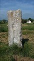 view gallery view galleryNE6.1 km |  Menhir des Demoiselles - Colombiers-sur-Seulles - France Menhir des Demoiselles - Colombiers-sur-Seulles - France
in Megalithic Monuments Le menhir des Demoiselles ou de la Pierre Debout est un menhir situé au lieu-dit la Pierre.
The menhir of the Demoiselles or the Stone Standing is a menhir located at the place called Pierre. posted by: Alfouine location: Normandie, France date approved: 08/05/2017 last visited: 02/14/2020 |
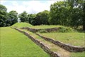 view gallery view galleryNE6.8 km | Tumulus de Colombiers-sur-Seulles - in Megalithic Monuments Dating from 4200 to 4000 BC, the burial mound in Colombiers-sur-Seulles is a 60 metre-long monument. // Rencontre 4200-4000 BC, le tumulus de Colombiers-sur-Seulles est de 60 mètres de long monument. posted by: Trail Blaisers location: Normandie, France date approved: 07/11/2015 last visited: 02/14/2020 |
 view gallery view galleryNE6.8 km |  Tumulus de Colombiers-sur-Seulles - France Tumulus de Colombiers-sur-Seulles - France
in News Article Locations Ce tumulus, monument funéraire mesurant 60m de long, a été érigé pendant le Néolithique, la période des premiers agriculteurs
This tumulus, funerary monument measuring 60m long, was erected during the Neolithic period, the period of the first farmers posted by: Alfouine location: Normandie, France date approved: 08/04/2017 last visited: 02/14/2020 |
 view gallery view galleryNE6.8 km | Tumulus de Colombiers-sur-Seulles - France in Wikipedia Entries Ce tumulus, monument funéraire mesurant 60m de long, a été érigé pendant le Néolithique, la période des premiers agriculteurs
This tumulus, funerary monument measuring 60m long, was erected during the Neolithic period, the period of the first farmers posted by: Alfouine location: Normandie, France date approved: 08/04/2017 last visited: 02/14/2020 |
 view gallery view galleryNE6.8 km |  Tumulus de Colombiers-sur-Seulles - France Tumulus de Colombiers-sur-Seulles - France
in Official Local Tourism Attractions Ce tumulus, monument funéraire mesurant 60m de long, a été érigé pendant le Néolithique, la période des premiers agriculteurs
This tumulus, funerary monument measuring 60m long, was erected during the Neolithic period, the period of the first farmers posted by: Alfouine location: Normandie, France date approved: 08/04/2017 last visited: 02/14/2020 |
 view gallery view galleryNE6.8 km |  Tumulus de Colombiers-sur-Seulles - France Tumulus de Colombiers-sur-Seulles - France
in Remains of Settlements Ce tumulus, monument funéraire mesurant 60m de long, a été érigé pendant le Néolithique, la période des premiers agriculteurs
This tumulus, funerary monument measuring 60m long, was erected during the Neolithic period, the period of the first farmers posted by: Alfouine location: Normandie, France date approved: 08/04/2017 last visited: 07/25/2022 |
 view gallery view galleryNE6.8 km |  Tumulus de Colombiers-sur-Seulles - France Tumulus de Colombiers-sur-Seulles - France
in Cairns Ce tumulus, monument funéraire mesurant 60m de long, a été érigé pendant le Néolithique, la période des premiers agriculteurs
This tumulus, funerary monument measuring 60m long, was erected during the Neolithic period, the period of the first farmers posted by: Alfouine location: Normandie, France date approved: 08/09/2017 last visited: 07/25/2022 |
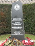
 view gallery view galleryN8.2 km |  Le mémorial britannique de Normandie - Ver-sur-Mer, France Le mémorial britannique de Normandie - Ver-sur-Mer, France
in World War II Memorials / Monuments [EN] A memorial, built on an 18 hectare site, on the heights of Ver-sur-Mer, honors the memory of the 22,442 soldiers, sailors and airmen who fell on the battlefield.
[FR] Un mémorial, édifié sur un site de 18 hectares, sur les hauteurs de Ver-sur-Mer, honore la mémoire des 22 442 soldats, marins et aviateurs tombés au champ d’honneur. posted by: pmaupin location: Normandie, France date approved: 07/10/2021 last visited: 03/11/2021 |
 view gallery view galleryN8.4 km | World War II Libérateurs Memorial - Asnelles, France in World War II Memorials / Monuments A monument to the British soldiers that landed at and liberated the village of Asnelles during World War II is located on the Normandy Coast in Asnelles, France. posted by: Marine Biologist location: Normandie, France date approved: 11/12/2014 last visited: 12/05/2014 |
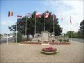 view gallery view galleryN8.4 km |  World War II Libérateurs Memorial - Asnelles, France World War II Libérateurs Memorial - Asnelles, France
in Flags of the World This monument to the British soldiers that landed at and liberated the village of Asnelles during World War II is located on the Normandy Coast in Asnelles, France. It includes the flags of eight Allied countries. posted by: Marine Biologist location: Normandie, France date approved: 03/12/2017 last visited: never |
 view gallery view galleryN8.4 km | World War II Memorial - Asnelles, France in World War II Memorials / Monuments A monument to the 2nd Battalion of the South Wales Borderers is located on the Normandy Coast in Asnelles, France. posted by: Marine Biologist location: Normandie, France date approved: 11/12/2014 last visited: 02/14/2020 |
 view gallery view gallery W8.5 km W8.5 km
|  Red Telephone Box à Saint Vigor Le Grand Red Telephone Box à Saint Vigor Le Grand
in Red Telephone Boxes A Red Telephone Box at St Vigor Le Grand, near Bayeux. posted by: junkys location: Normandie, France date approved: 03/27/2016 last visited: 04/05/2016 |
 view gallery view gallery NW8.9 km NW8.9 km
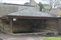
| ") Le Lavoir d'Arromanches - Arromanches les bains, France Le Lavoir d'Arromanches - Arromanches les bains, France
in Lavoir (wash houses) [EN] A wash house from the end of the 19th century, located rue de l'abreuvoir in Arromanches les Bains.
[FR] Un lavoir de la fin du XIXème siècle, situé rue de l'abreuvoir à Arromanches les bains. posted by: pmaupin location: Normandie, France date approved: 03/31/2021 last visited: 07/19/2022 |
 view gallery view galleryN8.9 km |  Orientation tabel at Gold Beach - Arromanches les Bains, France Orientation tabel at Gold Beach - Arromanches les Bains, France
in Orientation Tables 360 degrees Orientation table at Gold Beach about the D-Day landings posted by: PetjeOp location: Normandie, France date approved: 08/26/2022 last visited: 03/22/2023 |
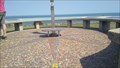 view gallery view galleryN8.9 km |  Compas rose - Arromanches, France Compas rose - Arromanches, France
in Compass Roses Compass rose on the lookout point at Goldbeach posted by: PetjeOp location: Normandie, France date approved: 08/26/2022 last visited: 01/28/2023 |
 view gallery view galleryN8.9 km |  Coin up binocular - Arromanches les Bains, France Coin up binocular - Arromanches les Bains, France
in Coin-Op Binoculars At the elevated orientation table is also a binocular posted by: PetjeOp location: Normandie, France date approved: 08/26/2022 last visited: 03/13/2023 |
|