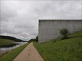
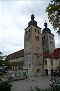
 view gallery view gallery N12.6 km N12.6 km
|   Scheitelhaltung - Pierheim, Hilpoltstein, Lk Roth, Bayern, D Scheitelhaltung - Pierheim, Hilpoltstein, Lk Roth, Bayern, D
in Abstract Public Sculptures Granitskulptur an der Wasserscheide Rhein-Donau. --- Granite sculpture near the Rhine-Danube watershed. posted by:  lumbricus lumbricus location: Bayern, Germany date approved: 02/10/2012 last visited: 12/20/2012 |
 view gallery view galleryN12.9 km |  ALDI Süd, Hilpoltstein, BY, Germany ALDI Süd, Hilpoltstein, BY, Germany
in ALDI Stores ALDI Süd-Markt in Hilpoltstein - ALDI South-store in Hilpoltstein posted by: pruppi location: Bayern, Germany date approved: 11/06/2019 last visited: never |
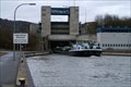 view gallery view gallery E14 km E14 km
|  Schleuse Berching Schleuse Berching
in Waterway Locks, Planes and Lifts In der Schleuse Berching des Rhein-Main-Donau-Kanals werden die Schiffe 17 m gehoben oder gesenkt, und zwar von 372 m auf 389 m Seehöhe.<br>In Berching locks of the Rhine-Main-Danube Canal the boats are lifted 17 m from an altidude of 372 m to 389 m. posted by: Schatz-Jaeger location: Bayern, Germany date approved: 10/06/2009 last visited: 05/21/2017 |
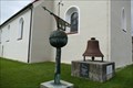 view gallery view galleryE14.3 km |  Antike Wetterfahne - Berching, Bavaria, Germany Antike Wetterfahne - Berching, Bavaria, Germany
in Unique Weathervanes Alte Wetterfahne/Turmspitze neben der Pfarrkirche St. Lorenz in Berching. --- Old unique weathervane near the church St. Lorenz in Berching. posted by: lumbricus location: Bayern, Germany date approved: 09/26/2017 last visited: never |
 view gallery view galleryE14.6 km |  Katholische Pfarr- und Abteikirche Mariä Himmelfahrt - Plankstetten, Berching, Bavaria, Germany Katholische Pfarr- und Abteikirche Mariä Himmelfahrt - Plankstetten, Berching, Bavaria, Germany
in Roman Catholic Churches Katholische Pfarr- und Abteikirche Mariä Himmelfahrt des Klosters Plankstetten am Main-Donau-Kanal. --- Catholic parish church and abbey church of the Assumption of the Virgin Mary of the abbey Plankstetten located near the Main-Donau-Kanal. posted by: lumbricus location: Bayern, Germany date approved: 10/20/2016 last visited: 07/09/2023 |
 view gallery view galleryE15.1 km |  "Schöner Blick" am Steinweg, Berching, Bavaria, Germany "Schöner Blick" am Steinweg, Berching, Bavaria, Germany
in Cityscapes [DE]
Östlich von Berching gibt es den Steinweg, bei dem man auch den sog. "Schönen Blick" erreicht.
[EN]
East of Berching there is the Steinweg, where you also reach the so-called "Schönen Blick". posted by: aendgraend location: Bayern, Germany date approved: 06/25/2022 last visited: never |
 view gallery view galleryN16.1 km | Lock/Schleuse Eckersmühlen, Germany, BY in Waterway Locks, Planes and Lifts The lock at Eckersmühlen, Germany, Bayern is a part of Main-Danube-Canal. The ships are liftet nearly 25 meters. posted by:  Tante.Hossi Tante.Hossi location: Bayern, Germany date approved: 10/17/2010 last visited: 10/01/2019 |
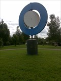 view gallery view galleryN16.7 km |  unknown - Rothsee, Germany, BY unknown - Rothsee, Germany, BY
in Kinetic Sculpture and Art This is an artwork located on a small island inside a lake called 'Rothsee'. You have to walk over a small bridge to access the island. posted by: Tante.Hossi location: Bayern, Germany date approved: 11/17/2010 last visited: 08/26/2017 |
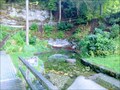 view gallery view gallery SE16.9 km SE16.9 km
|  Karstquelle "Grüner Topf" in Kipfenberg, Germany Karstquelle "Grüner Topf" in Kipfenberg, Germany
in Natural Springs Der Grüne Topf liegt am Hangfuß östlich des Ortsrandes von Grösdorf. posted by: friesede location: Bayern, Germany date approved: 10/11/2017 last visited: never |
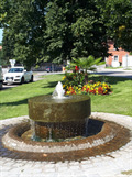 view gallery view gallery NW17.5 km NW17.5 km
|  Dorfbrunnen, Eckersmühlen, Roth, BY, Germany Dorfbrunnen, Eckersmühlen, Roth, BY, Germany
in Fountains Dorfbrunnen in Eckersmühlen - Fountain in Eckersmuehlen posted by: pruppi location: Bayern, Germany date approved: 09/03/2019 last visited: never |
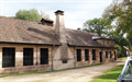 view gallery view galleryNW18.3 km |  Historischer Eisenhammer, Roth, BY, Germany Historischer Eisenhammer, Roth, BY, Germany
in History Museums Industriemuseum in Roth-Eckersmühlen -
Industrial Museum in Roth-Eckersmühlen posted by: pruppi location: Bayern, Germany date approved: 10/04/2019 last visited: never |
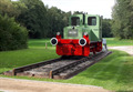 view gallery view galleryNW18.3 km |  Deutz-Lokomotive, Roth-Eckersmühlen, BY, Germany Deutz-Lokomotive, Roth-Eckersmühlen, BY, Germany
in Locomotives Deutz-Lokomotive beim Museum Eisenhammer bei Roth-Eckersmühlen - Deutz locomotive at the Museum Eisenhammer at Roth-Eckersmühlen posted by: pruppi location: Bayern, Germany date approved: 10/12/2019 last visited: never |
 view gallery view gallery W18.8 km W18.8 km
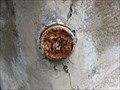
|  TP-Bolzen - Haupttor Wülzburg - Weißenburg, Germany, BY TP-Bolzen - Haupttor Wülzburg - Weißenburg, Germany, BY
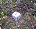
in German Trigonometric Points At the inner side of the main gate (German: Haupttor) of the so-called 'Wülzburg', an old fortification outside of Weißenburg, Germany, Bayern, exists a German TrigPoint stud. posted by: Tante.Hossi location: Bayern, Germany date approved: 02/24/2015 last visited: never |
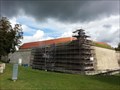
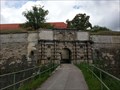 view gallery view galleryW18.8 km |  Festung Wülzburg - Weißenburg, Germany, BY Festung Wülzburg - Weißenburg, Germany, BY
in Historic Forts On top of a hill above the city of Weißenburg, Germany, Bayern is the old fortification 'Wülzburg' located. posted by: Tante.Hossi location: Bayern, Germany date approved: 10/18/2017 last visited: never |
 view gallery view galleryW18.8 km |  Wülzburg - Weißenburg, Germany, BY Wülzburg - Weißenburg, Germany, BY
in Wikipedia Entries On top of a hill above the city of Weißenburg, Germany, Bayern is the old fortification 'Wülzburg' located. It has its own entry at the Wikipedia. posted by: Tante.Hossi location: Bayern, Germany date approved: 11/16/2017 last visited: never |
 view gallery view galleryW18.8 km |  Festung Wülzburg - Weißenburg, Germany, BY Festung Wülzburg - Weißenburg, Germany, BY
in Deutsche Denkmallisten - German Monument Registers On top of a hill above the city of Weißenburg, Germany, Bayern is the old fortification 'Wülzburg' located. It is listed in the German Monument Registers and has its own entry at the Wikipedia. posted by: Tante.Hossi location: Bayern, Germany date approved: 11/15/2017 last visited: never |
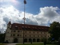
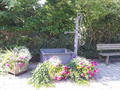
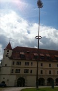 view gallery view galleryW18.8 km |  Maibaum - Wülzburg - Weißenburg, Germany, BW Maibaum - Wülzburg - Weißenburg, Germany, BW
in Holiday Displays At the inner courtyard of the old fortification 'Wülzburg' outside of Weißenburg, Germany, Bayern is a 'Maibaum' (May Tree) located. It can be visited through the May of each year. posted by: Tante.Hossi location: Bayern, Germany date approved: 10/18/2017 last visited: never |
 view gallery view galleryW19 km |  Mono - Wülzburg - Weißenburg, Germany, BY Mono - Wülzburg - Weißenburg, Germany, BY
in Coin-Op Binoculars This is a monocular located at the famous 'Wülzburg', an old fotification, nearby to Weißenburg, Germany, Bayern. posted by: Tante.Hossi location: Bayern, Germany date approved: 06/23/2015 last visited: never |
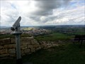
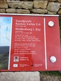 view gallery view galleryW19 km |  630m - Bastion Kaltes Eck - Weißenburg, Germany, BY 630m - Bastion Kaltes Eck - Weißenburg, Germany, BY
in Elevation Signs At the old fort 'Wülzburg' located on top of a hill above the city of Weißenburg, Germany, Bayern is an oriantation table located which indicates an elevation of 630 meters above sea level. posted by: Tante.Hossi location: Bayern, Germany date approved: 10/12/2017 last visited: never |
 view gallery view galleryN19 km | Dorfbrunnen, Eichelburg, Roth, BY, Germany in Fountains Dorfbrunnen in Eichelburg- Fountain in Eichelburg posted by: pruppi location: Bayern, Germany date approved: 09/03/2019 last visited: 03/22/2021 |
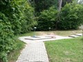 view gallery view galleryW19.2 km |  Minigolf - Pleinfeld, Germany, BY Minigolf - Pleinfeld, Germany, BY
in Miniature Golf This is a Miniature Golf Course outside of Pleinfeld, Germany, Bayern. It can be found at the 'Sommerrodelbahn'. posted by: Tante.Hossi location: Bayern, Germany date approved: 10/12/2014 last visited: never |
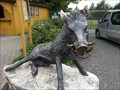 view gallery view galleryW19.3 km |  Wild Boar - Pleinfeld, Germany, BY Wild Boar - Pleinfeld, Germany, BY
in Figurative Public Sculpture This is the sculpture of a Wild Boar (German: Wildschwein). It is located at the 'Sommerrodelbahn' in front of a small zoo outside of Pleinfeld, Germany, Bayern. posted by: Tante.Hossi location: Bayern, Germany date approved: 11/04/2014 last visited: never |
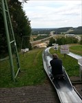 view gallery view galleryW19.3 km |  Sommerrodelbahn - Pleinfeld, Germany, BY Sommerrodelbahn - Pleinfeld, Germany, BY
in Bobsleigh Chutes and Mountain Slides Outside of Pleinfeld, Germany, Bayern exists a Mountain Slidge called 'Sommerrodelbahn'. It is located at the so-called 'Erlebnispark Pleinfeld'. posted by: Tante.Hossi location: Bayern, Germany date approved: 10/19/2015 last visited: never |
 view gallery view galleryN19.6 km | TP, Roth (Eichelburg), BY, Germany in German Trigonometric Points Trigonometrischer Punkt nahe Roth Eichelburg - Trigonometric Point near Roth Eichelburg posted by: pruppi location: Bayern, Germany date approved: 10/30/2019 last visited: 03/22/2021 |
 view gallery view galleryN19.6 km |  Jakobusweg - Roth-Eichelburg, BY, Germany Jakobusweg - Roth-Eichelburg, BY, Germany
in Way of St. James Wegweiser des Jakobusweges Nürnberg-Eichstätt - Marker of the Jakobusweg Nuremberg-Eichstätt posted by: pruppi location: Bayern, Germany date approved: 10/30/2019 last visited: 03/22/2021 |
|