 view gallery view gallery SW0 km SW0 km
|   Langley Township Control Survey 10LT013, Aldergrove Langley Township Control Survey 10LT013, Aldergrove
in Canadian Benchmarks Marker 'Langley Township Control Survey "10LT013"' is a 76 mm diameter bronze disk set into the concrete curb on the southwest corner of Fraser Highway and 272nd Street in Aldergrove. posted by:  LED Lightbulb LED Lightbulb location: British Columbia, Canada date approved: 02/10/2015 last visited: never |
 view gallery view gallery N0.3 km N0.3 km
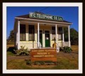
|  Alder Grove Telephone Museum & Community Archives — Aldergrove, BC Alder Grove Telephone Museum & Community Archives — Aldergrove, BC
in History Museums In the early 20th century telephone wires were strung across the globe linking homes and businesses, small towns and cities. The Alder Grove Telephone Museum & Community Archives displays the early equipment of this communication technology. posted by: Dunbar Loop location: British Columbia, Canada date approved: 11/09/2015 last visited: never |
 view gallery view gallery NW0.3 km NW0.3 km
|  F. J. Hart Building — Aldergrove, BC F. J. Hart Building — Aldergrove, BC
in Western Canadian Heritage When completed in 1910 the F.J. Hart Building operated as a bank, home improvement store, and realty office. By 1914, the pre-fabricated building changed hands and become the BC Telephone Company exchange. posted by: Dunbar Loop location: British Columbia, Canada date approved: 11/08/2022 last visited: never |
 view gallery view gallery S0.5 km S0.5 km
| British Columbia Control Survey 92H0611, Aldergrove in Canadian Benchmarks Marker 'British Columbia Control Survey "92H0611"' is a 76 mm diameter bronze disk set into the concrete curb on the southwest corner of 28th Avenue and 272nd Street in Aldergrove. posted by: LED Lightbulb location: British Columbia, Canada date approved: 02/16/2015 last visited: never |
 view gallery view galleryS0.6 km | British Columbia Control Survey 92H0608, Aldergrove in Canadian Benchmarks Marker 'British Columbia Control Survey "92H0608"' is a 76 mm diameter bronze disk set into the concrete curb on the north side of 28th Avenue midway between 272A Street and 272B Street in Aldergrove. posted by: LED Lightbulb location: British Columbia, Canada date approved: 02/16/2015 last visited: never |
 view gallery view gallery SE0.6 km SE0.6 km
| British Columbia Control Survey 92H0609, Aldergrove in Canadian Benchmarks Marker 'British Columbia Control Survey "92H0609"' is a 76 mm diameter bronze disk set into the concrete curb on the north side of the 27400 block (~65 metres west of address 27411) of 28th Avenue in Aldergrove. posted by: LED Lightbulb location: British Columbia, Canada date approved: 02/16/2015 last visited: never |
 view gallery view gallery E0.8 km E0.8 km
| British Columbia Legal Survey 611 dated 2004, Aldergrove in Canadian Benchmarks Marker 'British Columbia Legal Survey "611"' dated "2004" is a 76 mm diameter bronze disk set into the concrete curb on the west side of 276 Street near its southwest corner with 31 Avenue in Aldergrove. posted by: LED Lightbulb location: British Columbia, Canada date approved: 02/24/2015 last visited: never |
 view gallery view gallerySE1 km | Langley Township Control Survey 10LT015, Aldergrove in Canadian Benchmarks Marker 'Langley Township Control Survey "10LT015"' is a 76 mm diameter bronze disk set into the concrete curb on the northwest corner of 28th Avenue and 276th Street in Aldergrove. posted by: LED Lightbulb location: British Columbia, Canada date approved: 02/10/2015 last visited: never |
 view gallery view gallery W1 km W1 km
|  Fraser Valley Regional Library - Aldergrove Library — Langley, BC Fraser Valley Regional Library - Aldergrove Library — Langley, BC
in Libraries Located in the community of Aldergrove, this small library is part of network branches serving the Fraser Valley from Boston Bar to Delta. posted by: Dunbar Loop location: British Columbia, Canada date approved: 10/01/2010 last visited: 08/31/2011 |
 view gallery view galleryW1.1 km | British Columbia Control Survey 88H4728, Aldergrove in Canadian Benchmarks Marker 'British Columbia Control Survey "88H4728"' is a 76 mm diameter bronze disk set into the concrete curb on the southeast corner of 29 Avenue and 266B Street in Aldergrove. posted by: LED Lightbulb location: British Columbia, Canada date approved: 02/24/2015 last visited: never |
 view gallery view galleryW1.1 km | British Columbia Control Survey 80H2599, Aldergrove in Canadian Benchmarks Marker 'British Columbia Control Survey "80H2599"' also marked "514" and dated "1981" is a 76 mm diameter bronze disk set into the concrete sidewalk at the first power pole west of 266B Street on the north side of 29 Avenue in Aldergrove. posted by: LED Lightbulb location: British Columbia, Canada date approved: 02/24/2015 last visited: never |
 view gallery view galleryW1.1 km |  Our Glorious Dead - Aldergrove Cenotaph Our Glorious Dead - Aldergrove Cenotaph
in World War I Memorials and Monuments Located at the Algergrove Legion, this cenotaph pays tribute to soldiers lost in the First World War, Second World War, and Korean War. posted by:  grafinator grafinator location: British Columbia, Canada date approved: 06/09/2012 last visited: 07/06/2012 |
 view gallery view galleryW1.4 km |  Mile 35 - Aldergrove, BC Mile 35 - Aldergrove, BC
in Milestones One of the few remaining milestones along the Fraser Highway and beyond. posted by: bcrockcrawler, xstitcher, & BMXer location: British Columbia, Canada date approved: 06/28/2010 last visited: 01/19/2016 |
 view gallery view galleryW1.4 km |  Fox and Hounds Neighbourhood Pub - Aldergrove, BC Fox and Hounds Neighbourhood Pub - Aldergrove, BC
in Red Telephone Boxes A rather beat up Telephone box at a pub. posted by: bcrockcrawler, xstitcher, & BMXer location: British Columbia, Canada date approved: 06/28/2010 last visited: 08/01/2010 |
 view gallery view galleryW1.6 km |  Tim Hortons - Fraser Highway - Aldergrove, BC Tim Hortons - Fraser Highway - Aldergrove, BC
in Tim Horton's Restaurants This busy Tim Hortons is located along the Fraser Highway at 264th St posted by: bcrockcrawler, xstitcher, & BMXer location: British Columbia, Canada date approved: 06/30/2010 last visited: 12/01/2022 |
 view gallery view galleryW1.6 km |  A & W - Aldergrove, BC A & W - Aldergrove, BC
in A + W Restaurants Aldergrove's A&W is located along the Fraser Highway at 264th St. posted by: bcrockcrawler, xstitcher, & BMXer location: British Columbia, Canada date approved: 06/30/2010 last visited: 12/01/2022 |
 view gallery view galleryW1.6 km | British Columbia Control Survey 80H2598, Aldergrove in Canadian Benchmarks Marker 'British Columbia Control Survey "80H2598"' also marked "514" and dated "1981" is a 76 mm diameter bronze disk set into the concrete sidewalk on the northeast corner of 264 Street and 29 Avenue in Aldergrove. posted by: LED Lightbulb location: British Columbia, Canada date approved: 02/24/2015 last visited: never |
 view gallery view galleryE1.6 km | Tim Hortons @ 28060 Fraser Hwy — Abbotsford, BC in Tim Horton's Restaurants Located on the site of the Blue Star Motel, this Tim Horton's reflects the changing face of the Fraser Valley and the Fraser Highway in particular. posted by: Dunbar Loop location: British Columbia, Canada date approved: 03/30/2012 last visited: 04/27/2013 |
 view gallery view galleryE1.8 km | Mile Post 37 — Abbotsford, BC in Milestones Located on the Fraser Highway Mile Post 37 still has traces of its original yellow paint. It marks the 37th mile from the Main Post Office in Vancouver, that was then located at Hastings and Granville. posted by: Dunbar Loop location: British Columbia, Canada date approved: 01/30/2012 last visited: never |
 view gallery view galleryE2.4 km |  Aberdeen Cemetary — Abbotsford, BC Aberdeen Cemetary — Abbotsford, BC
in Worldwide Cemeteries Located in the Aberdeen community of Abbotsford, this century old cemetary was about 300 graves in it. posted by: Dunbar Loop location: British Columbia, Canada date approved: 01/17/2012 last visited: never |
 view gallery view galleryW2.4 km |  Twilight Drive-In; Aldergrove,British Columbia,Canada Twilight Drive-In; Aldergrove,British Columbia,Canada
in Drive-In Movie Theaters Previously the hill crest drive-in in surry BC; but was shut down by the city for rezoning purposes, then the owners felt a desire to keep the theatre alive. so they moved it to Aldergrove BC posted by: mud-dog27 location: British Columbia, Canada date approved: 12/06/2006 last visited: 05/18/2015 |
 view gallery view galleryE2.6 km |  ABBOTSFORD FIRE HALL No. 3 ABBOTSFORD FIRE HALL No. 3
in Firehouses Located in the West Abbotsford community of Aberdeen, this fire hall serves a growing urban area as well as an expansive rural community. posted by: Dunbar Loop location: British Columbia, Canada date approved: 01/14/2012 last visited: 06/06/2013 |
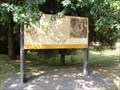 view gallery view gallery NE3.5 km NE3.5 km
|  Food and Cooking of the Northwest Coast Indians — Abbotsford, BC Food and Cooking of the Northwest Coast Indians — Abbotsford, BC
in British Columbia Heritage Markers The Northwest First Nations used heated rocks to cook and steam their food. This sign provides an overview of how they did these cooking techniques. posted by: Dunbar Loop location: British Columbia, Canada date approved: 08/08/2010 last visited: 06/27/2014 |
 view gallery view galleryNE3.7 km |  Bradner Road Rest Area — Abbotsford, BC Bradner Road Rest Area — Abbotsford, BC
in Highway Rest Areas Heading west on the Trans Canada Highway this the last rest area before entering into the Greater Vancouver area. You'll find it after Exit 83. posted by: Dunbar Loop location: British Columbia, Canada date approved: 08/09/2010 last visited: 09/07/2016 |
 view gallery view galleryNE3.9 km |  Bradner Road West Webcam - Abbotsford, BC Bradner Road West Webcam - Abbotsford, BC
in Web Cameras This BC Highways Webcam is about 300 feet east of the Bradner Road underpass on Highway 1. posted by: T0SHEA location: British Columbia, Canada date approved: 08/19/2013 last visited: 01/03/2014 |
|