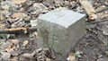
 view gallery view gallery S1.1 km S1.1 km
|   World's first oil well World's first oil well
in First of its Kind The world's first drilled oil well!... ? posted by:  sTeamTraen sTeamTraen location: Grand-Est, France date approved: 09/20/2007 last visited: 04/08/2014 |
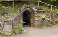
 view gallery view gallery NW2.3 km NW2.3 km
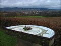
|  Soultzerkopf - Lobsan, France Soultzerkopf - Lobsan, France
in Orientation Tables [FR] Table d'orientation du Soultzerkopf
[ENG] Orientation table of the Soultzerkopf posted by: Chris777 location: France date approved: 08/24/2008 last visited: 09/23/2019 |
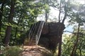
 view gallery view gallery NE10.1 km NE10.1 km
| Table d'Orientation du Geissberg in Orientation Tables Vue sur Wissembourg posted by: ballbreaker67 location: Grand-Est, France date approved: 01/13/2014 last visited: 03/09/2014 |
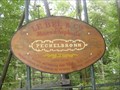
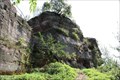
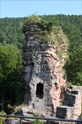
 view gallery view galleryNW10.6 km |  Château du Fleckenstein - Alsace, France Château du Fleckenstein - Alsace, France
in Castles The Fleckenstein, is a medieval castle rock in Northern Alsace (France) near the border of Rhineland-Palatinate. She gave as an ancestral castle of the noble family of Fleckenstein the name. posted by:  KaPsTeam KaPsTeam location: Grand-Est, France date approved: 01/11/2014 last visited: 05/22/2014 |
 view gallery view galleryNE10.8 km |  Hôtel de ville de Wissembourg - Wissembourg - France Hôtel de ville de Wissembourg - Wissembourg - France
in Wikipedia Entries [FR] Monument historique construit de 1741 à 1752, selon les plans de Massol. [EN] Historic monument built from 1741 to 1752, according to the plans of Massol. posted by: PaulLassiter location: Grand-Est, France date approved: 01/13/2023 last visited: never |
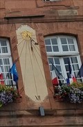 view gallery view galleryNE10.8 km |  Cadran solaire sur l'Hôtel de ville - Wissembourg - France Cadran solaire sur l'Hôtel de ville - Wissembourg - France
in Sundials [EN] This vertically mounted sundial is located on the main façade of the Wissembourg town hall. [FR] Un cadran solaire monté verticalement est situé sur la façade principale de l'hôtel de ville de Wissembourg. posted by: PaulLassiter location: Grand-Est, France date approved: 02/08/2023 last visited: never |
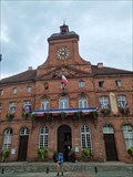 view gallery view galleryNE10.8 km |  Hôtel de ville - Wissembourg - France Hôtel de ville - Wissembourg - France
in City and Town Halls [FR] Monument historique construit de 1741 à 1752, selon les plans de Massol. [EN] Historic monument built from 1741 to 1752, according to the plans of Massol. posted by: PaulLassiter location: Grand-Est, France date approved: 01/21/2023 last visited: never |
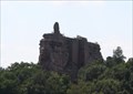
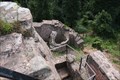
 view gallery view galleryNW10.9 km | Burg Loewenstein, Alsace, France in Castles The Lowenstein, also called Lindenschmitt, is the ruin of a medieval castle rock in Wingen, Alsace. It stands in 550 meters altitude in the immediate vicinity of the High Castle, Wegelnburg and Fleckensteins. posted by: KaPsTeam location: Grand-Est, France date approved: 01/11/2014 last visited: 04/16/2017 |
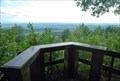
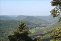
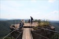 view gallery view galleryNW10.9 km |  Sicht von Löwenburg in die Vogesen, France Sicht von Löwenburg in die Vogesen, France
in Scenic Overlooks View from the castle "Löwenburg" into the "Vogesen". posted by: KaPsTeam location: Grand-Est, France date approved: 01/11/2014 last visited: 01/25/2014 |
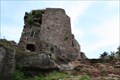
 view gallery view galleryNW11.1 km | Château de Froensbourg - Niedersteinbach/France in Castles The Frönsburg(French Château de Froensbourg) is a medieval rock castle at Niedersteinbach in Alsace. posted by: KaPsTeam location: Grand-Est, France date approved: 02/04/2014 last visited: never |
 view gallery view galleryNW11.3 km | Hohenbourg - Alsace, France in Castles The "Hohenbourg" is located in Alsace in the direct vicinity of Wegelnburg and the "Löwenstein" on the 551-meter high castle hill. posted by: KaPsTeam location: Grand-Est, France date approved: 01/11/2014 last visited: 04/16/2017 |
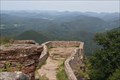 view gallery view gallery N11.7 km N11.7 km
| Sicht von Wegelnburg in den Pfälzerwald, Germany in Scenic Overlooks View from the castle "Wegelnburg" into the "Pfälzer Wald" posted by: KaPsTeam location: Rheinland-Pfalz, Germany date approved: 01/11/2014 last visited: 04/16/2017 |
 view gallery view galleryN11.7 km | Wegelnburg - Nothweiler, Germany in Castles The Wegelnburg, also called Wegelenburg, is a ruined castle between Schönau and Nothweiler in Rhineland-Palatinate and the highest castle in the Palatinate. posted by: KaPsTeam location: Rheinland-Pfalz, Germany date approved: 01/11/2014 last visited: 04/16/2017 |
 view gallery view galleryN11.7 km |  Schlossberg (571m)- Nothweiler/RLP/Germany Schlossberg (571m)- Nothweiler/RLP/Germany
in German Trigonometric Points [DE] Topographischer Punkt auf dem Berg Schlossberg ( 571 m ).[EN] German Trigonometric Point on the top of the mountain Schlossberg (571m) posted by: zappapapa location: Rheinland-Pfalz, Germany date approved: 01/14/2018 last visited: never |
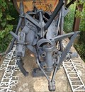
 view gallery view galleryN11.9 km |  St-Anna-Stollen Nothweiler/Germany St-Anna-Stollen Nothweiler/Germany
in Mines Visitors mine near Nothweiler posted by: KaPsTeam location: Rheinland-Pfalz, Germany date approved: 01/14/2021 last visited: 09/01/2013 |
 view gallery view galleryNW12.4 km | Aussicht vom Saufels - Petersbächel/France in Scenic Overlooks View from the Rock Saufels into the Pfälzer Wald and the village Petersbächel. posted by: KaPsTeam location: Grand-Est, France date approved: 01/19/2014 last visited: never |
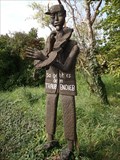 view gallery view galleryNE12.4 km |  Traubendieb - Schweigen-Rechtenbach, Germany Traubendieb - Schweigen-Rechtenbach, Germany
in Outside Wooden Display Carvings So ergeht es dem Traubendieb. / Carving showing an arrested thief who has been stealing in the vineyards. posted by: DieCacherGirls location: Rheinland-Pfalz, Germany date approved: 09/15/2014 last visited: 11/29/2014 |
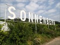 view gallery view galleryNE12.4 km |  Sonnenberg - Schweigen-Rechtenbach, Germany Sonnenberg - Schweigen-Rechtenbach, Germany
in Letters on Hills Der "Sonnenberg" bezeichnet einen Weinberg in Schweigen-Rechtenbach. / "Sonnenberg" is the name of a famous vineyard. posted by: DieCacherGirls location: Rheinland-Pfalz, Germany date approved: 09/18/2014 last visited: 11/29/2014 |
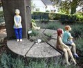 view gallery view galleryNE12.6 km |  Skulpturengarten - Schweigen-Rechtenbach, Germany Skulpturengarten - Schweigen-Rechtenbach, Germany
in Sculpture Gardens Kleiner Skulpturengarten im Ortskern von Schweigen. / Small sculpture garden in the historic city center of Schweigen. posted by: DieCacherGirls location: Rheinland-Pfalz, Germany date approved: 09/18/2014 last visited: 11/29/2014 |
 view gallery view galleryNE12.6 km |  Grapevine phylloxera - Schweigen-Rechtenbach, Germany Grapevine phylloxera - Schweigen-Rechtenbach, Germany
in Insect Sculptures Wurzelreblaus in den Weinbergen beim Deutschen Weintor. / Grapevine phylloxera in the vineyards near the monument "Deutsches Weintor". posted by: DieCacherGirls location: Rheinland-Pfalz, Germany date approved: 09/12/2014 last visited: 11/29/2014 |
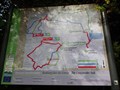 view gallery view galleryNE12.7 km |  Cross border trail - Schweigen-Rechtenbach, Germany Cross border trail - Schweigen-Rechtenbach, Germany
in Hiking and walking trailheads Grenzüberschreitende Wanderwege zwischen Deutschland und Frankreich. / Cross border trail between Germany and France. posted by: DieCacherGirls location: Rheinland-Pfalz, Germany date approved: 09/10/2014 last visited: never |
 view gallery view galleryN12.7 km | Aussicht vom Kulmenfelsen - Nothweiler/Germany in Scenic Overlooks View from the rock Kulmenfelsen. posted by: KaPsTeam location: Rheinland-Pfalz, Germany date approved: 02/09/2014 last visited: never |
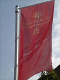 view gallery view galleryNE12.7 km |  Deutsches Weintor wine cooperative - Schweigen-Rechtenbach, Germany Deutsches Weintor wine cooperative - Schweigen-Rechtenbach, Germany
in Flags of Organizations Die Winzergenossenschaft Deutsches Weintor besteht 50 Jahren aus über 600 Winzerfamilien entlang der Südlichen Weinstraße. / This wine cooperative spans more than 600 winemaker families in southern Palatinate. posted by: DieCacherGirls location: Rheinland-Pfalz, Germany date approved: 09/10/2014 last visited: never |
 view gallery view galleryNE12.7 km |  Weingut Cuntz–Scheu - Schweigen-Rechtenbach, Germany Weingut Cuntz–Scheu - Schweigen-Rechtenbach, Germany
in Wineries Das Weingut Cuntz–Scheu befindet sich direkt am Deutschen Weintor und am ersten Weinlehrpfad der Welt. / The winery Cuntz-Scheu is located at the monument "Deutsches Weintor" near the first educational trail across the vineyards worldwide. posted by: DieCacherGirls location: Rheinland-Pfalz, Germany date approved: 09/10/2014 last visited: never |
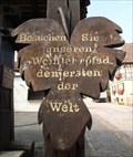 view gallery view galleryNE12.7 km | First educational trail across the vineyards - Schweigen-Rechtenbach, Germany in First of its Kind Der erste Weinlehrpfad der Welt in Schweigen-Rechtenbach. / The first educational trail across the vineyards worldwide. posted by: DieCacherGirls location: Rheinland-Pfalz, Germany date approved: 09/10/2014 last visited: 11/29/2014 |
|