 view gallery view gallery SE0.3 km SE0.3 km
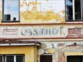
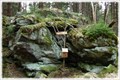
|   Nejstarsi hospoda na Sumave - Horni Vltavice, Czech Republic Nejstarsi hospoda na Sumave - Horni Vltavice, Czech Republic
in Ghost Signs Nejstarsi hospoda na Sumave // Das älteste Gasthaus im Böhmerwald // The oldest inn in the Bohemian Forest posted by:  ToRo61 ToRo61 location: Jihočeský kraj, Czechia date approved: 11/13/2013 last visited: 07/11/2022 |
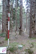
 view gallery view gallery W2.7 km W2.7 km
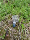
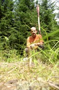
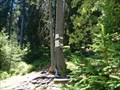
|  TB 3907-2 Jilm TB 3907-2 Jilm
in Czech Geodetic Points TrB na kopci Jilm - 931m Mezi Borovou Ladou a Horní Vltavicí posted by:  Gotici Gotici location: Jihočeský kraj, Czechia date approved: 08/07/2011 last visited: 10/01/2011 |
 view gallery view gallery NE3.1 km NE3.1 km
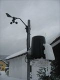
|  Amateur weather station Kubova Hut Amateur weather station Kubova Hut
in Weather Stations Small automatic amateur weather station posted by: Ponik & team location: Jihočeský kraj, Czechia date approved: 02/14/2010 last visited: 03/18/2015 |
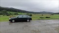
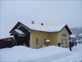 view gallery view galleryNE3.1 km |  Kubova Hut - Czech Republic Kubova Hut - Czech Republic
in Train Stations/Depots The highest railway station in Czech Lands. The altitude is 995m. posted by: haggaeus location: Jihočeský kraj, Czechia date approved: 02/15/2010 last visited: 08/02/2015 |
 view gallery view gallery N3.1 km N3.1 km
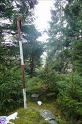
| TB 3901-16 Obrovec in Czech Geodetic Points Na vrcholu tisícovky Obrovec / On the top of Obrovec hill posted by: Mamuti location: Jihočeský kraj, Czechia date approved: 08/29/2010 last visited: 08/14/2021 |
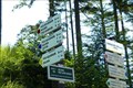
 view gallery view galleryW3.2 km |  'You Are Here' Map at Brezova Lada, CZE 'You Are Here' Map at Brezova Lada, CZE
in 'You Are Here' Maps This map is one of many in Sumava National Park and Protected Landscape Area. posted by: walden2 location: Jihočeský kraj, Czechia date approved: 09/27/2011 last visited: 04/19/2012 |
 view gallery view gallery SW3.4 km SW3.4 km
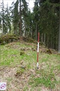
| TB 3907-5 Orlov in Czech Geodetic Points Trigonometrický bod na Šumave posted by: pavlikVB location: Jihočeský kraj, Czechia date approved: 11/04/2012 last visited: never |
 view gallery view gallery NW4 km NW4 km
| TB 3906-21 Lisci hora in Czech Geodetic Points Trigonometrický bod jihozápadne od Vimperka posted by: pavlikVB location: Jihočeský kraj, Czechia date approved: 05/02/2011 last visited: 08/14/2021 |
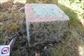
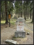
 view gallery view gallerySE4.8 km | BTP 3164 Horní Vltavice - Lenora in Czech Geodetic Points Bod 1.rádu základního tíhového bodového pole. posted by: pavlikVB location: Jihočeský kraj, Czechia date approved: 06/08/2009 last visited: 05/22/2014 |
 view gallery view gallery E5 km E5 km
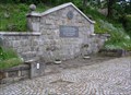
|  Záton (žst) Záton (žst)
in Direction and Distance Arrows [CZ]Rozcestník je na križovatce modré se zelenou TZ u železnicní stanice.
[EN]The signpost is at the junction of blue and green track near railway station. posted by: prokestom location: Jihočeský kraj, Czechia date approved: 05/16/2019 last visited: 07/17/2019 |
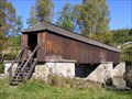 view gallery view gallerySE5.5 km |  Rechle u Lenory / Lenora-covered bridge Rechle u Lenory / Lenora-covered bridge
in Covered Bridges Krytý drevený most pres Vltavu na konci Lenory smerem na Volary.
EN:Covered bridge across Moldau river in Lenora. posted by: bartusko location: Jihočeský kraj, Czechia date approved: 05/11/2010 last visited: 10/08/2022 |
 view gallery view gallerySE5.5 km |  No. 112, Lenora-Vltava, CZ No. 112, Lenora-Vltava, CZ
in Tourist Stamps Photos Lenora Town, Vltava river. posted by: ToRo61 location: Jihočeský kraj, Czechia date approved: 10/31/2013 last visited: 10/08/2022 |
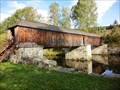 view gallery view gallerySE5.5 km |  Rechle u Lenory - Czech Republic Rechle u Lenory - Czech Republic
in Satellite Imagery Oddities The roofed wooden bridge [CZ: Rechle] posted by: ToRo61 location: Jihočeský kraj, Czechia date approved: 01/27/2017 last visited: 10/08/2022 |
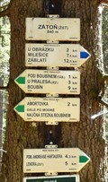
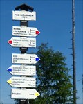 view gallery view galleryNE5.6 km | Rozcestník: Pod Boubínem in Direction and Distance Arrows Rozcestník Pod Boubínem je na odbocce k Johnovu kameni
Nadmorská výška: 1352 m posted by: prokestom location: Jihočeský kraj, Czechia date approved: 07/27/2015 last visited: 08/16/2021 |
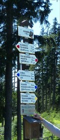 view gallery view galleryNE5.8 km | Rozcestník: Boubín in Direction and Distance Arrows Rozcestník stojí u rozhledny na Boubíne v nadmorské výšce 1362 metru. posted by: prokestom location: Jihočeský kraj, Czechia date approved: 07/27/2015 last visited: 08/16/2021 |
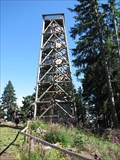 view gallery view galleryNE5.8 km |  Boubin, CZ, EU Boubin, CZ, EU
in Look-Out Towers The wooden tower posted by: ToRo61 location: Jihočeský kraj, Czechia date approved: 01/02/2011 last visited: 08/16/2021 |
 view gallery view galleryNE5.8 km |  Boubin - 1362 meters, CZ Boubin - 1362 meters, CZ
in Elevation Signs The fifth highest point of Czech Republic. posted by: ToRo61 location: Jihočeský kraj, Czechia date approved: 03/30/2011 last visited: 08/16/2021 |
 view gallery view galleryNE5.8 km | TB 3901-18, Boubin in Czech Geodetic Points Trigonometrický bod 3901-18, Boubin. posted by: ToRo61 location: Jihočeský kraj, Czechia date approved: 01/03/2011 last visited: 08/16/2021 |
 view gallery view galleryNW5.8 km |  Svetlá hora - Šumava, CZ Svetlá hora - Šumava, CZ
in Summit Registers Návštevní kniha na vrcholu Svetlé hory. /// Summit register on the top of Svetlá hora. posted by: Ursus PiPa location: Jihočeský kraj, Czechia date approved: 01/20/2012 last visited: 08/14/2021 |
 view gallery view galleryNW5.8 km | TB 3906-15 Svetla hora in Czech Geodetic Points Trigonometrický bod jihozápadne od Vimperka posted by: pavlikVB location: Jihočeský kraj, Czechia date approved: 05/02/2011 last visited: 08/14/2021 |
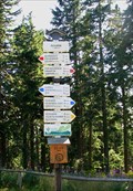
 view gallery view galleryNE6 km | Rozcestník: Boubínská severní cesta in Direction and Distance Arrows Rozcestník Boubínská severní cesta je pod dreveným schodištem k vrcholu Boubína posted by: prokestom location: Jihočeský kraj, Czechia date approved: 07/27/2015 last visited: 08/16/2021 |
 view gallery view galleryNE6 km |  Krížová smrc - Boubín/ CZ Krížová smrc - Boubín/ CZ
in Milestones Krížová smrc posted by: Waupe location: Jihočeský kraj, Czechia date approved: 04/05/2011 last visited: 07/17/2019 |
 view gallery view galleryNE6.1 km | Rozcestník: Na boubínské severní ceste in Direction and Distance Arrows Rozcestník: Na boubínské severní ceste je na mapy.cz pod názvem Pod Boubínem 1 posted by: prokestom location: Jihočeský kraj, Czechia date approved: 07/27/2015 last visited: 08/02/2015 |
 E6.3 km | U obrázku in Direction and Distance Arrows [CZ]Rozcestník je na križovatce modré TZ a nekolika neznacených cest.
[EN]The signpost is at the junction of blue and un-signed tracks. posted by: prokestom location: Jihočeský kraj, Czechia date approved: 05/16/2019 last visited: never |
 view gallery view galleryE6.3 km | TB 3901-21 Vetrin in Czech Geodetic Points Trigonometrický bod jihovýchodne od Boubína posted by: pavlikVB location: Jihočeský kraj, Czechia date approved: 11/05/2012 last visited: never |
|