 view gallery view gallery S9.8 km S9.8 km
|   Mulberry Whale, St Denis de Méré, Normandie, FR Mulberry Whale, St Denis de Méré, Normandie, FR
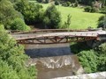
in World War II Sites This bridge "Le Pont des Bordeaux" over the Noireau near St Denis de Méré once formed part of the temporary "Mulberry" harbour at Arromanches. The original bridge was destroyed by the French Resistance shortly after D-Day. posted by:  Team Sieni Team Sieni location: Normandie, France date approved: 09/13/2013 last visited: 03/18/2021 |
 view gallery view gallery SW12.7 km SW12.7 km
|  Borne Kilometrique, Condé-sur-Noireau, France Borne Kilometrique, Condé-sur-Noireau, France
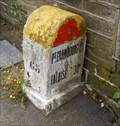
in Milestones A typical French Borne Kilometrique, in Condé-sur-Noireau posted by: Team Sieni location: Normandie, France date approved: 09/14/2013 last visited: 06/16/2016 |
 view gallery view gallery NW13.2 km NW13.2 km
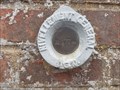
|  Benchmark - Grotte de Marie - Banneville-sur-Ajon (Calvados), France Benchmark - Grotte de Marie - Banneville-sur-Ajon (Calvados), France
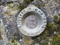
in French Benchmarks Repère de nivellement de la grotte de Banneville-sur-Ajon posted by:  junkys junkys location: Normandie, France date approved: 11/13/2018 last visited: 12/04/2019 |
 view gallery view gallery NE16.9 km NE16.9 km
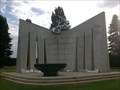
|  Cimetière Militaire Polonais - Urville - France Cimetière Militaire Polonais - Urville - France
in Outdoor Altars Un autel pour célébrées des messes au milieu des soldats polonais catholiques morts pour la paix durant la seconde guerre mondiale.
An altar to celebrate masses among Polish Catholic soldiers who died for peace during the Second World War. posted by: Alfouine location: Normandie, France date approved: 09/10/2017 last visited: 11/06/2021 |
 view gallery view galleryNE16.9 km |  Cimetière Militaire Polonais - Urville - France Cimetière Militaire Polonais - Urville - France
in Guest Books Livre d'or du cimetière Polonais d'Urville dans un magnifique emplacement chargé de symboles.
Guestbook of the Polish cemetery of Urville in a magnificent site loaded with symbols. posted by: Alfouine location: Normandie, France date approved: 09/05/2017 last visited: 02/23/2019 |
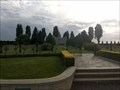 view gallery view galleryNE16.9 km |  Cimetière Militaire Polonais - Urville - France Cimetière Militaire Polonais - Urville - France
in Veteran Cemeteries Au bord de la RN158, à vingt kilomètres au Sud de Caen, le cimetière d’Urville est la dernière demeure de 696 combattants.
At the edge of the RN158, twenty kilometers south of Caen, the cemetery of Urville is the last residence of 696 fighters. posted by: Alfouine location: Normandie, France date approved: 09/06/2017 last visited: 02/23/2019 |
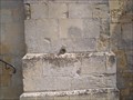
 view gallery view gallery E17.1 km E17.1 km
| Repère de Nivellement du bureau des Mines de Soumont in French Benchmarks Repère de nivellement situé sur l'ancienne propriété des Mines de Soumont. posted by: junkys location: Île-de-France, France date approved: 08/17/2017 last visited: 02/23/2019 |
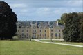 view gallery view galleryNW18.5 km |  Château de Villers Bocage - Villers-Bocage, France Château de Villers Bocage - Villers-Bocage, France
in Castles [EN] A 17th century castle at the exit of Villers Bocage, fully restored in 2015-2016 and transformed into a prestigious bed and breakfast.
[FR] Un Château du XVIIe siècle à la sortie de Villers Bocage, entièrement restauré en 2015-2016 et transformé en une prestigieuse chambre d'hôtes. posted by: pmaupin location: Normandie, France date approved: 10/11/2019 last visited: 09/30/2019 |
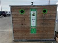 view gallery view galleryNW18.5 km |  Do - Parking Supermarché Leclerc - Villers-Bocage, France Do - Parking Supermarché Leclerc - Villers-Bocage, France
in Places for Recycling [EN] Recycling point for glass. [FR] Point de recyclage pour le verre. posted by: pmaupin location: Normandie, France date approved: 02/11/2020 last visited: 02/09/2020 |
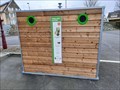 view gallery view galleryNW19.2 km | DO -- Parking Rue de Vire -- Villers-Bocage, France in Places for Recycling [EN] Recycling point for glass. [FR] Point de recyclage pour le verre. posted by: pmaupin location: Normandie, France date approved: 04/14/2023 last visited: 04/14/2023 |
 view gallery view galleryNW19.2 km |  Espace Fitness d'extérieur - Villers-Bocage Espace Fitness d'extérieur - Villers-Bocage
in Fitness Trails [EN] The town of Villers-Bocage has equipped itself with outdoor fitness equipment and free access pedals.
[FR] La ville de Villers-Bocage s'est équipée en extérieur d'appareils de fitness et de pédaliers en libre accès. posted by: pmaupin location: Normandie, France date approved: 04/17/2023 last visited: 04/15/2023 |
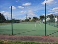 view gallery view galleryNW19.2 km |  Tennis Club- Villers-Bocage, France Tennis Club- Villers-Bocage, France
in Tennis Facilities [EN] The Tennis club offers access to 3 outdoor courts in resin.
[FR] Le Tennis club propose l'accés à 3 courts extérieurs en résine. posted by: pmaupin location: Normandie, France date approved: 04/17/2023 last visited: 04/15/2023 |
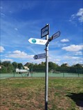 view gallery view galleryNW19.2 km |  Direction des Grands Tournois de Tennis - Villers-Bocage Direction des Grands Tournois de Tennis - Villers-Bocage
in Direction and Distance Arrows [EN] Multi-directional wooden sign indicating the different major Grand Slam Tennis tournaments.
[FR] Panneau multidirectionnel en bois indiquant les différents grands tournois de Tennis du grand Chelem. posted by: pmaupin location: Normandie, France date approved: 04/18/2023 last visited: 04/15/2023 |
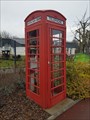 view gallery view gallery N19.6 km N19.6 km
|  Red Phone Box- Baron-sur-Odon - France Red Phone Box- Baron-sur-Odon - France
in Red Telephone Boxes A red phone box offered to the city of Baron-sur-Odon by the the bitisg city of Chittlehampton posted by: junkys location: Normandie, France date approved: 12/28/2017 last visited: 02/09/2019 |
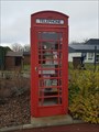 view gallery view galleryN19.6 km |  Red phone box book exchanges - Baron-sur-Odon, France Red phone box book exchanges - Baron-sur-Odon, France
in Free Community Book Exchanges [FR] une vieille cabine téléphonique rouge transformée en boîtes à livres
[EN] an old red phone box turned into a free community book exhanges box. posted by: junkys location: Normandie, France date approved: 12/28/2017 last visited: 02/09/2019 |
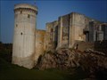
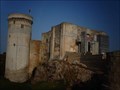 view gallery view galleryE21.1 km |  Le château de Falaise - Falaise, France Le château de Falaise - Falaise, France
in Satellite Imagery Oddities FR - château Guillaume-le-Conquérant est un château fort formé d'une enceinte, situé sur un éperon rocheux.
EN - The castle Guillaume-le-Conquérant is a fortified castle formed by an enclosure, located on a rocky spur. posted by: geotrouvtou59 location: Normandie, France date approved: 04/23/2020 last visited: 03/18/2021 |
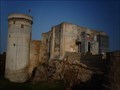 view gallery view galleryE21.1 km | Le château de Falaise - Falaise, France in Castles FR - château Guillaume-le-Conquérant est un château fort formé d'une enceinte, situé sur un éperon rocheux.
EN - The castle Guillaume-le-Conquérant is a fortified castle formed by an enclosure, located on a rocky spur. posted by: geotrouvtou59 location: Normandie, France date approved: 04/10/2020 last visited: 03/18/2021 |
 view gallery view galleryE21.2 km |  Le château de Falaise - Falaise, France Le château de Falaise - Falaise, France
in Monuments Historiques Français FR - château Guillaume-le-Conquérant est un château fort formé d'une enceinte, situé sur un éperon rocheux.
EN - The castle Guillaume-le-Conquérant is a fortified castle formed by an enclosure, located on a rocky spur. posted by: geotrouvtou59 location: Normandie, France date approved: 04/05/2020 last visited: 03/18/2021 |
 view gallery view galleryE21.2 km |  Le château de Falaise - Falaise, France Le château de Falaise - Falaise, France
in Wikipedia Entries FR - château Guillaume-le-Conquérant est un château fort formé d'une enceinte, situé sur un éperon rocheux.
EN - The castle Guillaume-le-Conquérant is a fortified castle formed by an enclosure, located on a rocky spur. posted by: geotrouvtou59 location: Normandie, France date approved: 04/05/2020 last visited: 03/18/2021 |
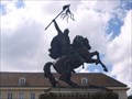 view gallery view galleryE21.4 km |  Guillaume le Conquerant. Falaise. France Guillaume le Conquerant. Falaise. France
in Monarchs of the World Statue de Guillaume le Conquerant posted by: lulu_et_compagnie location: Normandie, France date approved: 10/14/2015 last visited: 03/18/2021 |
 view gallery view galleryE21.4 km | benchmarks Eglise de Falaise in French Benchmarks Sur l'église posted by: lulu_et_compagnie location: Normandie, France date approved: 08/20/2013 last visited: 03/09/2019 |
 view gallery view gallerySW21.6 km |  Table d'orientation du mont de Cerisy - Orne, France Table d'orientation du mont de Cerisy - Orne, France
in Orientation Tables Table d'orientation du mont de Cerisy.
Orientation table of Mount Cerisy. posted by: AlexEmilie location: Normandie, France date approved: 07/06/2016 last visited: 03/26/2021 |
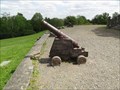 view gallery view gallerySW21.6 km |  Les canons du mont de Cerisy - France Les canons du mont de Cerisy - France
in Static Artillery Displays Canons au pied du fort du Mont de Cerisy, dans la commune de Cerisy-Belle-Etoile, dans l'Orne. posted by: AlexEmilie location: Normandie, France date approved: 07/04/2016 last visited: 03/26/2021 |
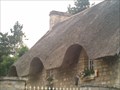 view gallery view galleryN22.2 km |  Une chaumière - Verson - France Une chaumière - Verson - France
in Thatch Cottages Au hasard d'une promenade une maison an toit de chaume.
At random a walk a house with thatched roof posted by: Alfouine location: Normandie, France date approved: 08/05/2017 last visited: 06/06/2021 |
 view gallery view galleryE22.2 km | Benchmarks N-D de Guibray à Falaise in French Benchmarks Sur l'église posted by: lulu_et_compagnie location: Normandie, France date approved: 08/20/2013 last visited: 06/17/2015 |
|