 view gallery view gallery SE9 km SE9 km
|   Clyde Community Cemetery - Clyde ND Clyde Community Cemetery - Clyde ND
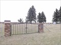
in Worldwide Cemeteries This Cemetery on 94th Street NE just east of Highway 5 in Clyde, North Dakota. posted by:  PeterNoG PeterNoG location: Manitoba, Canada date approved: 11/14/2014 last visited: 11/23/2014 |
 view gallery view gallery SW13.2 km SW13.2 km
| Ellison Cemetery - Towner County ND in Worldwide Cemeteries This Cemetery is on Highway 5 about 7 miles east of Rocklake in Towner County, North Dakota. posted by: PeterNoG location: North Dakota date approved: 07/24/2016 last visited: 10/22/2014 |
 view gallery view gallery W23.5 km W23.5 km
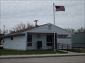
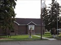
|  Rock Lake ND 58365 Rock Lake ND 58365
in U.S. Post Offices This Post Office is on Main Street between Ellsberry Avenue and Brooks Avenue in Rock Lake, North Dakota. posted by: PeterNoG location: North Dakota date approved: 08/26/2013 last visited: 05/24/2013 |
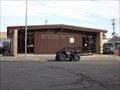
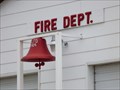 view gallery view galleryW23.7 km |  Fire Dept. Fire Dept.
in Firehouses This Firehouse for the Rock Lake Fire Department is on Eller Ave at Main Street in Rock Lake, North Dakota. posted by: PeterNoG location: North Dakota date approved: 08/20/2013 last visited: 05/24/2013 |
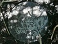
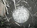
 view gallery view galleryW23.7 km |  TE1902: Rock Lake Municipal Water Tank - Rock Lake ND TE1902: Rock Lake Municipal Water Tank - Rock Lake ND
in U.S. Benchmarks This Benchmark is behind the Fire Department on Eller Ave at Main Street in Rock Lake, North Dakota. posted by: PeterNoG location: North Dakota date approved: 08/26/2013 last visited: 05/24/2013 |
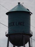 view gallery view galleryW23.7 km |  Water Tower - Rock Lake ND Water Tower - Rock Lake ND
in Water Towers This Water Tower is behind Fire Department on Eller Ave at Main Street in Rock Lake, North Dakota. posted by: PeterNoG location: North Dakota date approved: 08/18/2013 last visited: 05/24/2013 |
 view gallery view gallery NE27.8 km NE27.8 km
|  BM 25409 aka Star Mound - Snowflake MB BM 25409 aka Star Mound - Snowflake MB
in Canadian Benchmarks This benchmark disk is about 3 miles WNW of Snowflake on top of Nebogwagin Butte at the site of an old schoolhouse and museum. posted by: PeterNoG location: Manitoba, Canada date approved: 03/15/2008 last visited: 07/20/2014 |
 view gallery view gallery E41.5 km E41.5 km
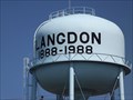
| Water Tower (west) - Langdon ND in Water Towers This Water Tower, one of two in town, is on 12th Avenue west of 14th Street in Langdon, North Dakota. posted by: PeterNoG location: North Dakota date approved: 08/18/2013 last visited: 05/24/2013 |
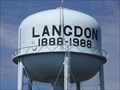 view gallery view galleryE42.6 km | Water Tower (east) - Langdon ND in Water Towers This Water Tower, one of two in town, is on 14th Avenue near 4th Street in Langdon, North Dakota. posted by: PeterNoG location: North Dakota date approved: 08/18/2013 last visited: 05/24/2013 |
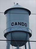 view gallery view gallerySW44.4 km | Water Tower - Cando ND in Water Towers This Water Tower is on 3rd Street near 7th Avenue in Cando, North Dakota. posted by: PeterNoG location: North Dakota date approved: 08/29/2013 last visited: 05/24/2013 |
 view gallery view gallerySW44.4 km | TE1973: Cando Municipal Water Tank - Cando ND in U.S. Benchmarks This Benchmark is on 3rd Street near 7th Avenue in Cando, North Dakota. posted by: PeterNoG location: North Dakota date approved: 08/27/2013 last visited: 05/24/2013 |
 view gallery view galleryNE47.6 km | T1 R7 S9 10 4 3 - Morden Area MB in Canadian Benchmarks This cadastral survey mark is 19 meters west of a section road (1.6 km east of Hwy 31) and 11 meters south of Hwy 201 (1.6 km north of the U.S. border). posted by: PeterNoG location: Manitoba, Canada date approved: 07/14/2009 last visited: 06/24/2009 |
 view gallery view galleryNE47.6 km |  PLSS T1 R7 S9 10 4 3 - Morden Area MB PLSS T1 R7 S9 10 4 3 - Morden Area MB
in Public Land Survey Marks This Public Land Survey Mark is 19 meters west of a section road (1.6 km east of Hwy 31) and 11 meters south of Hwy 201 (1.6 km north of the U.S. border). posted by: PeterNoG location: Manitoba, Canada date approved: 06/12/2014 last visited: 06/24/2009 |
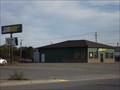
 view gallery view galleryW49.4 km | Rolla ND 58367 in U.S. Post Offices This Post Office is on 1st Avenue Southeast at 2nd Street Southeast in Rolla, North Dakota. posted by: PeterNoG location: North Dakota date approved: 04/08/2012 last visited: 09/28/2011 |
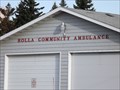 view gallery view galleryW49.7 km |  Rolla Community Ambulance - Rolla ND Rolla Community Ambulance - Rolla ND
in Paramedic Stations This Paramedic Station is on 5th Avenue NE at 3rd Street NE in Rolla, North Dakota. posted by: PeterNoG location: North Dakota date approved: 11/11/2011 last visited: 09/28/2011 |
 view gallery view galleryNE49.7 km | T3 R9W S27 26 22 23 - Manitou MB in Canadian Benchmarks This cadastral survey mark is on Hwy 3, 3.2 km (2 miles) west of Manitou. posted by: PeterNoG location: Manitoba, Canada date approved: 07/11/2009 last visited: 06/14/2009 |
 view gallery view galleryNE49.7 km | PLSS - T3 R9W S27 26 22 23 - Manitou MB in Public Land Survey Marks This Public Land Survey Mark is on Hwy 3, 3.2 km (2 miles) west of Manitou, Manitoba. posted by: PeterNoG location: Manitoba, Canada date approved: 06/13/2014 last visited: 06/14/2009 |
 view gallery view galleryW49.9 km |  "Fred C. Wagner Post #235 - American Legion" - Rolla ND "Fred C. Wagner Post #235 - American Legion" - Rolla ND
in Legion Posts and Branches This American Legion Post is on 1st Street NE at 3rd Avenue NE in Rolla, North Dakota. posted by: PeterNoG location: North Dakota date approved: 05/04/2012 last visited: 09/28/2011 |
 view gallery view galleryW49.9 km | Water Tower - Rolla ND in Water Towers This large white Water Tower is on off Harris Court on the north side of Rolla, North Dakota. posted by: PeterNoG location: North Dakota date approved: 12/06/2011 last visited: 09/28/2011 |
 view gallery view galleryW49.9 km |  Subway - Rolla ND Subway - Rolla ND
in Subway Restaurants This Subway is on Main Avenue West (Hwy 281 & Hwy 5) just west of Hwy 30 in Rolla, North Dakota. posted by: PeterNoG location: North Dakota date approved: 04/27/2012 last visited: 09/28/2011 |
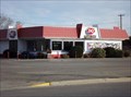 view gallery view galleryW49.9 km |  Dairy Queen - Rolla ND Dairy Queen - Rolla ND
in Dairy Queen Restaurants This Dairy Queen is on Main Avenue West (Hwy 281 & Hwy 5) just west of Hwy 30 in Rolla, North Dakota. posted by: PeterNoG location: North Dakota date approved: 04/27/2012 last visited: 09/29/2011 |
 view gallery view galleryE51.5 km |  Pembina Valley Provincial Park - Manitoba Pembina Valley Provincial Park - Manitoba
in State/Provincial Parks This Provincial park is just off Hwy 201, about 32 km southwest of Morden, Manitoba. posted by: PeterNoG location: Manitoba, Canada date approved: 10/13/2011 last visited: 06/11/2011 |
 view gallery view galleryNE51.7 km |  William Earl Sampson - Manitou MB William Earl Sampson - Manitou MB
in Dedicated Benches This bench is In Memory of William Earl Sampson 1923-2007 who lived his first 18 years in this house. posted by: PeterNoG location: Manitoba, Canada date approved: 07/13/2009 last visited: 07/08/2011 |
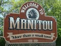 view gallery view galleryNE51.7 km |  More than a small town - Manitou MB More than a small town - Manitou MB
in Welcome Signs Manitou is a small town in south cental Manitoba about 125 km southwest of Winnipeg. posted by: PeterNoG location: Manitoba, Canada date approved: 07/13/2009 last visited: 05/13/2021 |
 view gallery view galleryNE51.7 km | 89M047 - Manitou MB in Canadian Benchmarks This benchmark disk is 27 meters north of Hwy 2 at the Welcome to Manitou sign that is 250 meters east of Hwy 244.
posted by: PeterNoG location: Manitoba, Canada date approved: 07/01/2009 last visited: 06/14/2009 |
|