 view gallery view gallery NW0.2 km NW0.2 km
|   JELENÍ VRCHY 885 m, Czech republic JELENÍ VRCHY 885 m, Czech republic
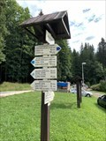
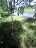
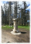
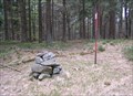
in Direction and Distance Arrows Turistický rozcestník u parkovište na Jelením vrchu. Tourist direction and distance arrows at the parking lot on Jelení vrch. posted by:  davidb11 davidb11 location: Jihočeský kraj, Czechia date approved: 08/05/2022 last visited: never |
 view gallery view gallery NE1 km NE1 km
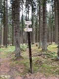
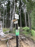
| JELENÍ JEZÍRKO 950 m, Czech republic in Direction and Distance Arrows Turistický rozcestník u Jeleního jezírka. Tourist direction and distance arrows next to Jelení lake. posted by: davidb11 location: Jihočeský kraj, Czechia date approved: 08/05/2022 last visited: never |
 view gallery view gallery E1.6 km E1.6 km
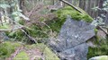
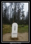
|  1049 m - Perník, Czech Republic 1049 m - Perník, Czech Republic
in Elevation Signs Výška uvedená na rozcestníku. Elevation Sign. posted by: davidb11 location: Jihočeský kraj, Czechia date approved: 11/27/2022 last visited: never |
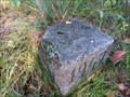
 view gallery view galleryE1.6 km |  TB 4023-27 U ohrady TB 4023-27 U ohrady
in Czech Geodetic Points Trigonometrický bod v NP Šumava posted by: pavlikVB location: Jihočeský kraj, Czechia date approved: 09/01/2016 last visited: never |
 view gallery view galleryE2.4 km | V OREŠÍ (SKÁLY) 960 m, Czech republic in Direction and Distance Arrows Turistický rozcestník u skal V Oreší. Tourist direction and distance arrows next to the rock V Oreší. posted by: davidb11 location: Jihočeský kraj, Czechia date approved: 08/05/2022 last visited: never |
 view gallery view gallery S3.4 km S3.4 km
| TB 3904-3 Konsky vrch in Czech Geodetic Points Trigonometrický bod na Šumave posted by: pavlikVB location: Jihočeský kraj, Czechia date approved: 05/28/2012 last visited: never |
 view gallery view galleryE3.5 km | TB 4023-34 Vltava sz. in Czech Geodetic Points Trigonometrický bod v NP Šumava posted by: pavlikVB location: Jihočeský kraj, Czechia date approved: 09/01/2016 last visited: never |
 view gallery view galleryE4.3 km | OVESNÁ (U PREJEZDU) 742 m, Czech republic in Direction and Distance Arrows Turistický rozcestník u železnicní zastávky Ovesná.. Tourist direction and distance arrows next the railway station Ovesná. posted by: davidb11 location: Jihočeský kraj, Czechia date approved: 08/05/2022 last visited: never |
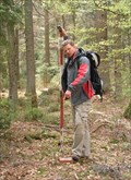
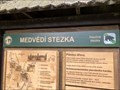 view gallery view galleryE4.3 km |  Naucná stezka Medvedí stezka, Czech republic Naucná stezka Medvedí stezka, Czech republic
in Self Guided Walks and Trails Naucná stezka Medvedí stezka. Self Guides Bear trail. posted by: davidb11 location: Jihočeský kraj, Czechia date approved: 12/05/2022 last visited: never |
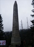 view gallery view galleryS4.7 km | TB 3904-2 Stifteruv pomnik in Czech Geodetic Points Trigonometrický bod nad Plešným jezerem posted by: pavlikVB location: Jihočeský kraj, Czechia date approved: 05/23/2010 last visited: 07/17/2016 |
 view gallery view galleryS4.7 km |  Plešné jezero, Šumava, CZ Plešné jezero, Šumava, CZ
in Natural Lakes Malebné horské jezero je jedním z osmi šumavských ledovcových jezer./// A picturesque mountain lake is One of the eight glacial kettle lakes in Šumava. posted by:  Ursus PiPa Ursus PiPa location: Jihočeský kraj, Czechia date approved: 02/20/2012 last visited: 07/02/2016 |
 view gallery view galleryS4.8 km |  No.1316, Rijište - Sumava, CZ No.1316, Rijište - Sumava, CZ
in Tourist Stamps Photos CS: Malá šumavská slat / EN: Small moor of the Bohemian Forest posted by: pavlikVB location: Jihočeský kraj, Czechia date approved: 05/31/2012 last visited: never |
 view gallery view galleryS5.1 km | TB 3904-4 Plechy in Czech Geodetic Points Trigonometrický bod na hore Plechý posted by: pavlikVB location: Jihočeský kraj, Czechia date approved: 05/06/2009 last visited: 08/21/2020 |
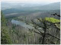
 view gallery view galleryS5.1 km |  Plechý - Šumava (Bohemian Forest / Böhmerwald) Mts. (Czech Republic) Plechý - Šumava (Bohemian Forest / Böhmerwald) Mts. (Czech Republic)
in Mountain Summits Plechý mountain (1 378 m) is the highest mountain of the Czech part of the Šumava mountains (Bohemian Forest). It lies 14 km west of the village Horní Planá and about 8 km south-west of the small village Nová Pec on the Czech-Austrian border. posted by: Dorcadion Team location: Jihočeský kraj, Czechia date approved: 05/27/2009 last visited: 08/21/2020 |
 view gallery view gallery N5.5 km N5.5 km
| TB 4023-8 U Chlumskeho mostu in Czech Geodetic Points Trigonometrický bod v I.zone NP Šumava posted by: pavlikVB location: Jihočeský kraj, Czechia date approved: 05/28/2017 last visited: never |
 view gallery view gallery W5.6 km W5.6 km
| TB 3903-14 Spicak in Czech Geodetic Points Trigonometrický bod na Šumavské tisícovce posted by: pavlikVB location: Jihočeský kraj, Czechia date approved: 05/11/2009 last visited: 08/19/2011 |
 view gallery view galleryE5.6 km | TB 4023-35 Zelnava z. in Czech Geodetic Points Trigonometrický bod nad Lipenskou nádrží posted by: pavlikVB location: Jihočeský kraj, Czechia date approved: 10/21/2023 last visited: never |
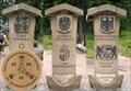 view gallery view gallery SW5.8 km SW5.8 km
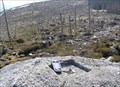
| No. 1971, Cesko-Nemecko-Rakouské Trojmezí, CZ in Tourist Stamps Photos Hranicní kámen v míste, kde se setkávají hranice trí zemí - Ceské republiky, Nemecka a Rakouska. /// Border stone on the tripoint of the Czech Republic (foreground), Austria and Germany. posted by: pavlikVB location: Jihočeský kraj, Czechia date approved: 05/01/2014 last visited: 08/21/2020 |
 view gallery view gallerySW5.8 km |  Trojmezí / Dreickenmark, Šumava - CZ, D, A Trojmezí / Dreickenmark, Šumava - CZ, D, A
in Tripoints and Multipoints Hranicní kámen v míste, kde se setkávají hranice trí zemí - Ceské republiky, Nemecka a Rakouska. /// Border stone on the tripoint of the Czech Republic (foreground), Austria and Germany. posted by: Ursus PiPa location: Jihočeský kraj, Czechia date approved: 03/12/2012 last visited: 08/21/2020 |
 view gallery view gallerySW5.8 km |  Trojmezí/ Three Borders (tripont) Trojmezí/ Three Borders (tripont)
in European Historic Survey Stones, Monuments and Benchmarks Trojmezí (Dreieckmark). Místo, kde se setkávají hranice CR, Rakouska a SRN/ Three Borders (Dreieckmark). The place where the borders meet Republic, Austria and Germany. posted by: Waupe location: Jihočeský kraj, Czechia date approved: 01/28/2011 last visited: 08/21/2020 |
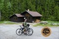
 view gallery view galleryW6 km |  Nové Údolí/ Neuthal Nové Údolí/ Neuthal
in Ghost Towns Nové Údolí posted by: Waupe location: Jihočeský kraj, Czechia date approved: 10/28/2010 last visited: 05/16/2016 |
 view gallery view gallery SE6.1 km SE6.1 km
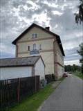
|  Železnicní stanice - Nová Pec, Czech republic Železnicní stanice - Nová Pec, Czech republic
in Train Stations/Depots Train station in Nová pec. posted by: davidb11 location: Jihočeský kraj, Czechia date approved: 11/09/2022 last visited: never |
 view gallery view galleryS6.6 km | TB 3904-6 Studnicna in Czech Geodetic Points Trigonometrický bod na hore Studnicná posted by: pavlikVB location: Jihočeský kraj, Czechia date approved: 05/06/2009 last visited: 07/05/2013 |
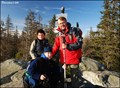
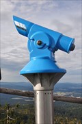 view gallery view gallerySW6.6 km |  BINO on the top of the "Hochstein"-BINO auf dem Hochstein BINO on the top of the "Hochstein"-BINO auf dem Hochstein
in Coin-Op Binoculars Awesome view from the top of the mountain "Hochstein" in the National Park "Bayrischer Wald". posted by: McGreifer location: Bayern, Germany date approved: 10/06/2015 last visited: 03/04/2018 |
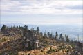 view gallery view gallerySW6.6 km |  Hochstein - Freyung-Grafenau - Bayern - Germany Hochstein - Freyung-Grafenau - Bayern - Germany
in Scenic Overlooks The "Hochstein" (alt. 1333m) is a cluster of granite blocks on the highest spot of the mountain "Dreisessel" in Bavaria.
Der Hochstein (1333 m ü. NN) ist eine Granitfelsgruppe an der höchsten Stelle des Dreisesselbergs im Bayerischen Wald posted by: McGreifer location: Bayern, Germany date approved: 02/22/2016 last visited: never |
|