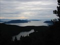
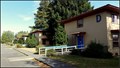
 view gallery view gallery SE10.6 km SE10.6 km
|   Morans Muggled! Morans Muggled!
in Scenic Overlooks This is an amazing overlook of the San Juan Islands. It is my second favorite site in the world. If you are blessed with clear skys, you will not be dissappointed. posted by:  soup soup location: Washington date approved: 06/25/2006 last visited: 05/01/2016 |
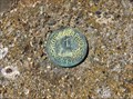 view gallery view gallery W11.7 km W11.7 km
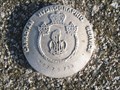
|  1-1965 - Saturna Island, British Columbia, Canada 1-1965 - Saturna Island, British Columbia, Canada
in Canadian Benchmarks This Hydrographic Service Canada benchmark is located in the top of a 1.5 foot tall concrete pyramid at East Point on Saturna Island, British Columbia, Canada. posted by:  The A-Team The A-Team location: British Columbia, Canada date approved: 08/11/2015 last visited: 06/07/2016 |
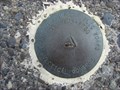
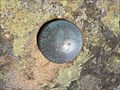 view gallery view galleryW11.7 km | International Boundary Commission Marker - Saturna Island, British Columbia, Canada in Canadian Benchmarks This International Boundary Commission marker is located on a rock outcrop just south of the old foghorn building at East Point on Saturna Island, British Columbia, Canada. posted by: The A-Team location: British Columbia, Canada date approved: 08/11/2015 last visited: 06/07/2016 |
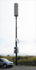 view gallery view gallery E13.5 km E13.5 km
|  Tsunami Warning Siren, Sandy Point, WA Tsunami Warning Siren, Sandy Point, WA
in Outdoor Warning Sirens A NOAA (National Oceanic Atmospheric Administration) tsunami warning siren at the Sandy Point fire station. posted by: hyperheidi location: Washington date approved: 10/01/2011 last visited: 09/26/2015 |
 view gallery view gallery SW14.5 km SW14.5 km
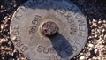
|  Broge A. Miner 18911 Survey Marker - Orcas Island Broge A. Miner 18911 Survey Marker - Orcas Island
in U.S. Benchmarks A survey disk at the top of Ship Peak (Turtleback Mountain), Orcas Island, WA posted by: North of 49 location: Washington date approved: 04/21/2015 last visited: 08/09/2015 |
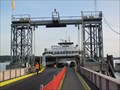
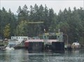
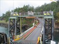
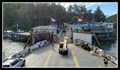
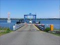 view gallery view galleryE15.9 km |  Lummi Island Ferry, Lummi Island Terminal — Lummi Island, WA Lummi Island Ferry, Lummi Island Terminal — Lummi Island, WA
in Ferries and Ferry Landings Crossing Hale Passage the Whatcom Chief has been doing this run since 1965. It serves the 650 or so people of Lummi Island. posted by: Dunbar Loop location: Washington date approved: 05/20/2015 last visited: never |
 view gallery view gallery NE17.9 km NE17.9 km
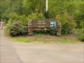
|  Birch Bay State Park Campground Birch Bay State Park Campground
in Campgrounds Birch Bay State Park Campground posted by: Phoneguy Canuck location: Washington date approved: 05/19/2009 last visited: 05/18/2009 |
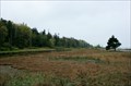 view gallery view galleryNE18.7 km |  Birch Bay State Park — Birch Bay, WA Birch Bay State Park — Birch Bay, WA
in State/Provincial Parks Where Terrell Creek meets the Strait of Georgia is Birch Bay State Park, a 194 acre area with campgrounds, wetlands, and a stony beach. posted by: Dunbar Loop location: Washington date approved: 05/10/2013 last visited: 07/20/2013 |
 view gallery view gallery S19.2 km S19.2 km
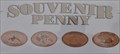
|  Cottage Gift Shop at Orcas Landing Penny Smasher Cottage Gift Shop at Orcas Landing Penny Smasher
in Penny Smashers This four-design hand-cranked Penny Smasher is in front of the Cottage Gift Shop at Orcas Landing on Orcas Island, Washington. No admission fee is required to access this machine but you do have to pay for parking and the ferry ride. posted by: brwhiz location: Washington date approved: 08/28/2012 last visited: 02/15/2023 |
 view gallery view galleryS19.2 km | Orcas Island Ferry Terminal - Orcas Island, Washington in Ferries and Ferry Landings We visited Orcas Island with a Road Scholar (Elderhostel) group. The Stone Lookout Tower on Mt. Constitution was the high point of our trip to Orcas Island. posted by: Rose Red location: Washington date approved: 11/07/2011 last visited: 02/23/2024 |
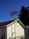 view gallery view galleryNE20 km |  Bike Rental - Birch Bay, WA Bike Rental - Birch Bay, WA
in Elevated Everyday Objects Bike on a stick posted by: 3Bobs location: Washington date approved: 08/21/2009 last visited: 10/25/2020 |
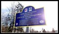 view gallery view galleryNE20.1 km |  Blaine Air Force Station — Birch Bay, WA Blaine Air Force Station — Birch Bay, WA
in Washington Historical Markers During the Cold War, the northern states were dotted with radar installation stations, Blaine, Washington was no exception. Just a few miles south of the Canadian border the Blaine Air Force Station operated until 1979. posted by: Dunbar Loop location: Washington date approved: 05/30/2019 last visited: never |
 view gallery view galleryNE20.3 km |  Blaine Air Force Station — Birch Bay, WA Blaine Air Force Station — Birch Bay, WA
in Abandoned Air Force Radar Sites From 1951 until 1979 the 757th Radar Squadron was located at the Blaine Air Force Station, just a few miles south of Blaine. posted by: Dunbar Loop location: Washington date approved: 11/08/2016 last visited: never |
 view gallery view galleryS20.3 km | Shaw Island Ferry Terminal - Shaw Island, Washington in Ferries and Ferry Landings The Shaw Island ferry terminal is located at the end of Blind Bay Road. posted by: Rose Red location: Washington date approved: 11/07/2011 last visited: 07/03/2022 |
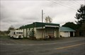 view gallery view galleryNE20.6 km |  Gas Station — Pleasant Valley (Whatcom County), WA Gas Station — Pleasant Valley (Whatcom County), WA
in Vintage Gas Stations This is one of those vintage gas stations on the side of the road that leaves you wondering why is it here. posted by: Dunbar Loop location: Washington date approved: 04/20/2013 last visited: never |
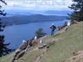 view gallery view galleryW20.8 km | Brown Ridge, Saturna Island BC in Scenic Hikes One of the best scenic hikes in the Gulf Islands is the Brown Ridge of Mt Warburton Pike on Saturna Island. The views along the ridge over the San Juan and Gulf Islands are spectacular. Most of the ridge trail is in the Gulf Islands National Park. posted by: arby101ca location: British Columbia, Canada date approved: 05/28/2010 last visited: 06/07/2016 |
 view gallery view galleryW20.9 km | Hydrographic marker 8779763 in Canadian Benchmarks On top of Mt Warburton Pike on Saturna Island posted by: sole seeker location: British Columbia, Canada date approved: 06/08/2008 last visited: 06/07/2016 |
 view gallery view galleryNE21.2 km | Birch Bay, Whatcom County Public Works Vertical Control in U.S. Benchmarks Vertical Control Disk posted by: Phoneguy Canuck location: Washington date approved: 05/19/2009 last visited: 05/17/2009 |
 view gallery view galleryS21.6 km | Lopez Island Ferry Terminal - Lopez Island, Washington in Ferries and Ferry Landings Lopez Island Terminal is located at the end of Ferry Road near Upright Head. posted by: Rose Red location: Washington date approved: 11/10/2011 last visited: 04/05/2021 |
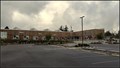 view gallery view galleryNE23.2 km |  Whatcom County Library System - Ferndale Library — Ferndale, WA Whatcom County Library System - Ferndale Library — Ferndale, WA
in Libraries This new building was opened in 2015 to serve the Ferndale community and surrounding areas. posted by: Dunbar Loop location: Washington date approved: 10/31/2016 last visited: 10/31/2016 |
 view gallery view galleryW23.3 km | Lyall Harbour Ferry Terminal – Saturna, BC in Ferries and Ferry Landings Of the five Southern Gulf Islands served by the BC Ferries network Saturna Island is the smallest. posted by: Dunbar Loop location: British Columbia, Canada date approved: 03/25/2019 last visited: never |
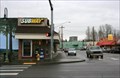 view gallery view galleryNE23.5 km |  Subway Store #13026 — Ferndale, WA Subway Store #13026 — Ferndale, WA
in Subway Restaurants Located in downtown Ferndale, this location of Subway is a busy location. posted by: Dunbar Loop location: Washington date approved: 03/27/2012 last visited: 11/21/2013 |
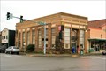 view gallery view galleryNE23.5 km |  First National Bank — Ferndale, WA First National Bank — Ferndale, WA
in Converted Bank Buildings A prominent brick building on Ferndale's Main Steet, the First National Bank is a graceful structure that has become a real estate office. posted by: Dunbar Loop location: Washington date approved: 03/27/2012 last visited: never |
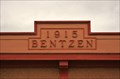 view gallery view galleryNE23.5 km |  1915 — Bentzen — Ferndale, WA 1915 — Bentzen — Ferndale, WA
in Dated Buildings and Cornerstones Located on Second Street, the Bentzen Building is a simple building that is just off Main Street. posted by: Dunbar Loop location: Washington date approved: 03/27/2012 last visited: never |
 NE23.5 km |  Steve Stedman Steve Stedman
in Bloggers My blogging site. Notes from Steve. posted by: Tangle and Cache location: Washington date approved: 09/08/2005 last visited: 12/12/2022 |
|