 view gallery view gallery E5.8 km E5.8 km
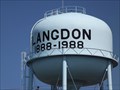
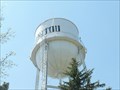
|   Water Tower (west) - Langdon ND Water Tower (west) - Langdon ND
in Water Towers This Water Tower, one of two in town, is on 12th Avenue west of 14th Street in Langdon, North Dakota. posted by:  PeterNoG PeterNoG location: North Dakota date approved: 08/18/2013 last visited: 05/24/2013 |
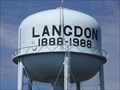 view gallery view galleryE6.9 km | Water Tower (east) - Langdon ND in Water Towers This Water Tower, one of two in town, is on 14th Avenue near 4th Street in Langdon, North Dakota. posted by: PeterNoG location: North Dakota date approved: 08/18/2013 last visited: 05/24/2013 |
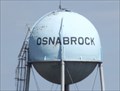 view gallery view galleryE25.1 km | Water Tower - Osnabrook ND in Water Towers This Water Tower is near Cyclone Street and 2nd Avenue in Osnabrook, North Dakota. posted by: PeterNoG location: North Dakota date approved: 08/18/2013 last visited: 05/24/2013 |
 view gallery view gallery N30.4 km N30.4 km
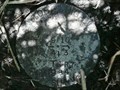
|  T1 R7 S9 10 4 3 - Morden Area MB T1 R7 S9 10 4 3 - Morden Area MB
in Canadian Benchmarks This cadastral survey mark is 19 meters west of a section road (1.6 km east of Hwy 31) and 11 meters south of Hwy 201 (1.6 km north of the U.S. border). posted by: PeterNoG location: Manitoba, Canada date approved: 07/14/2009 last visited: 06/24/2009 |
 view gallery view galleryN30.4 km |  PLSS T1 R7 S9 10 4 3 - Morden Area MB PLSS T1 R7 S9 10 4 3 - Morden Area MB
in Public Land Survey Marks This Public Land Survey Mark is 19 meters west of a section road (1.6 km east of Hwy 31) and 11 meters south of Hwy 201 (1.6 km north of the U.S. border). posted by: PeterNoG location: Manitoba, Canada date approved: 06/12/2014 last visited: 06/24/2009 |
 view gallery view gallery W31.4 km W31.4 km
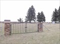
|  Clyde Community Cemetery - Clyde ND Clyde Community Cemetery - Clyde ND
in Worldwide Cemeteries This Cemetery on 94th Street NE just east of Highway 5 in Clyde, North Dakota. posted by: PeterNoG location: Manitoba, Canada date approved: 11/14/2014 last visited: 11/23/2014 |
 view gallery view gallery NE31.5 km NE31.5 km
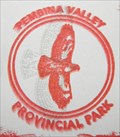
|  Pembina Valley Provincial Park - Manitoba Pembina Valley Provincial Park - Manitoba
in State/Provincial Parks This Provincial park is just off Hwy 201, about 32 km southwest of Morden, Manitoba. posted by: PeterNoG location: Manitoba, Canada date approved: 10/13/2011 last visited: 06/11/2011 |
 view gallery view gallery NW38.8 km NW38.8 km
| BM 25409 aka Star Mound - Snowflake MB in Canadian Benchmarks This benchmark disk is about 3 miles WNW of Snowflake on top of Nebogwagin Butte at the site of an old schoolhouse and museum. posted by: PeterNoG location: Manitoba, Canada date approved: 03/15/2008 last visited: 07/20/2014 |
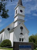 view gallery view galleryE44.6 km |  Vikur Lutheran Church - Mountain ND Vikur Lutheran Church - Mountain ND
in This Old Church This old church is located in the small town of Mountain ND. posted by: PeterNoG location: North Dakota date approved: 10/13/2008 last visited: 08/25/2015 |
 view gallery view galleryE44.6 km | Vikur Lutheran Church - Mountain ND in Lutheran Churches This historic Lutheran Church is located in the small town of Mountain ND. posted by: PeterNoG location: North Dakota date approved: 10/13/2008 last visited: 08/25/2015 |
 view gallery view galleryW46.2 km | Ellison Cemetery - Towner County ND in Worldwide Cemeteries This Cemetery is on Highway 5 about 7 miles east of Rocklake in Towner County, North Dakota. posted by: PeterNoG location: North Dakota date approved: 07/24/2016 last visited: 10/22/2014 |
 view gallery view galleryN49.1 km |  Darlingford MB Darlingford MB
in Pictorial Village Signs This Pictorial Village Sign is on Highway 3 just south of Darlingford, Manitoba. posted by: PeterNoG location: Manitoba, Canada date approved: 09/26/2011 last visited: 06/11/2011 |
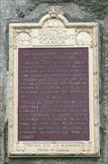 view gallery view galleryN49.1 km |  CNHS - La Verendrye's Journey to the Mandans ~ Darlingford MB CNHS - La Verendrye's Journey to the Mandans ~ Darlingford MB
in Canadian National Historic Sites This Canadian National Historic plaque is dedicated to La Verendrye's Journey to the Mandans. This 'Event' plaque is on a stone cairn in a wayside park at Hwy 3 and 31, one mile southeast of Darlingford, Manitoba. posted by: PeterNoG location: Manitoba, Canada date approved: 06/11/2010 last visited: 07/08/2011 |
 view gallery view galleryN49.7 km | Darlingford Cemetery - Darlingford MB in Worldwide Cemeteries This Cemetery is on Dufferin St just south of Darlingford, Manitoba and 750 metres (0.45 miles) north of Hwy 3. posted by: PeterNoG location: Manitoba, Canada date approved: 04/20/2012 last visited: 06/11/2010 |
 view gallery view galleryN50.1 km |  MHM Law Homestead - Darlingford MB MHM Law Homestead - Darlingford MB
in Manitoba Historical Markers This Manitoba Historical Marker is on the east side of Dufferin Street just south of Darlingford ,Manitoba. It's 200 metres north of the Darlingford Cemetery. posted by: PeterNoG location: Manitoba, Canada date approved: 10/18/2011 last visited: 07/08/2011 |
 view gallery view galleryN50.2 km |  DARLINGFORD PO R0G 0L0 DARLINGFORD PO R0G 0L0
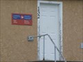
in Canada Post Offices A plain rural Post Office on Railway Ave in Darlingford, Manitoba. posted by: PeterNoG location: Manitoba, Canada date approved: 07/07/2010 last visited: 06/11/2010 |
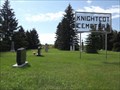 view gallery view galleryN50.5 km | Knightcot Cemetery - Thornhill MB in Worldwide Cemeteries This Cemetery is on the south side of Highway 3 at Road 36 West, 3.2 km west of Thornhill in the RM of Pembina. posted by: PeterNoG location: Manitoba, Canada date approved: 10/29/2014 last visited: 11/06/2014 |
 view gallery view galleryNE52.8 km |  Minnewasta Recreational Trail - Lake Minnewasta Recreation Area Minnewasta Recreational Trail - Lake Minnewasta Recreation Area
in Hiking and walking trailheads The main access point for a series of trails around Lake Minnewasta posted by: PM8 location: Manitoba, Canada date approved: 06/09/2018 last visited: never |
 view gallery view galleryNE53.3 km |  Bühler Boardwalk - Colert Beach - Morden MB Bühler Boardwalk - Colert Beach - Morden MB
in Coastal Boardwalks This boardwalk runs along Colert Beach just west of Morden MB. posted by: PeterNoG location: Manitoba, Canada date approved: 03/18/2010 last visited: 06/03/2018 |
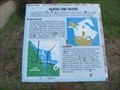 view gallery view galleryNE53.3 km |  Glacial Lake Agassiz - Morden, Manitoba, Canada Glacial Lake Agassiz - Morden, Manitoba, Canada
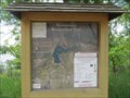
in Places of Geologic Significance A sign explaining the significance and extent of Glacial Lake Agassiz posted by: PM8 location: Manitoba, Canada date approved: 06/08/2018 last visited: never |
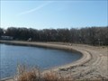 view gallery view galleryNE53.4 km |  Colert Beach - Morden MB Colert Beach - Morden MB
in Beaches Colert Beach is just west of Morden MB in Lake Minnewasta Recreation Area. posted by: PeterNoG location: Manitoba, Canada date approved: 03/22/2010 last visited: 05/13/2021 |
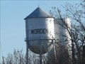 view gallery view galleryNE53.4 km | Water Tower - Morden MB in Water Towers These two water tower are on the west side of Morden MB. posted by: PeterNoG location: Manitoba, Canada date approved: 03/19/2010 last visited: 05/13/2021 |
 view gallery view galleryN53.8 km |  Pembina Valley Provincial Park Passport Stamp Pembina Valley Provincial Park Passport Stamp
in State Park Passport Locations The Park Passport Stamp for Pembina Valley Provincial Park can NOT be obtained at the park. It's available at Manitoba Conservation District Office, 240 Frontage Rd, Manitou, Manitoba. posted by: PeterNoG location: Manitoba, Canada date approved: 11/03/2011 last visited: 07/08/2011 |
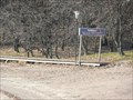
 view gallery view galleryN53.9 km | Water Tower - Manitou MB in Water Towers A small town water tower on a hill that can be seen for miles. posted by: PeterNoG location: Manitoba, Canada date approved: 07/12/2009 last visited: 05/13/2021 |
 view gallery view galleryNE53.9 km |  Super 8 - Morden MB Super 8 - Morden MB
in Recommended Accommodation This Super 8 is on the west side of Morden MB on the Colert Beach Road. posted by: PeterNoG location: Manitoba, Canada date approved: 03/19/2010 last visited: 07/08/2011 |
|