 view gallery view gallery W3.4 km W3.4 km
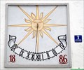
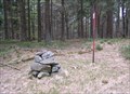
|   Geiermühle SUNDIAL, Waldkirchen, Bavaria, Germany Geiermühle SUNDIAL, Waldkirchen, Bavaria, Germany
in Sundials Sundial on the Geiermühle (watermill called Geiermühle) posted by:  ChickenRaider ChickenRaider location: Bayern, Germany date approved: 04/05/2010 last visited: never |
 view gallery view gallery NE8.9 km NE8.9 km
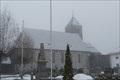
|  Katholische Pfarrkirche St. Sigismund - Altreichenau, Bavaria, Germany Katholische Pfarrkirche St. Sigismund - Altreichenau, Bavaria, Germany
in Roman Catholic Churches Katholische Pfarrkirche St. Sigismund in Altreichenau, Bayern. posted by: lumbricus location: Bayern, Germany date approved: 07/09/2021 last visited: never |
 view gallery view gallery NW13.2 km NW13.2 km
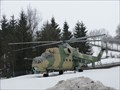
|  Russischer Kampfhubschrauber - Freyung, Lk Freyung-Grafenau, Bayern, D Russischer Kampfhubschrauber - Freyung, Lk Freyung-Grafenau, Bayern, D
in Static Aircraft Displays Russischer Kamphubschrauber Mil Mi-24 vor dem Max Fuchs Outdoor Laden. --- Russian attack helicopter Mil Ni-24 infront of the Max Fuchs Outdoor Shop. posted by: lumbricus location: Bayern, Germany date approved: 03/23/2012 last visited: 09/03/2016 |
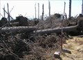
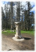
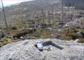
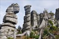 view gallery view galleryNE13.8 km |  Wollsackverwitterung am Hochstein - Bayern - Germany Wollsackverwitterung am Hochstein - Bayern - Germany
in Places of Geologic Significance Impressive rock formation next to the walking track towards the "Hochstein"
Beeindruckende Felsformation neben dem Fußweg zum Hochstein posted by:  McGreifer McGreifer location: Bayern, Germany date approved: 02/22/2016 last visited: never |
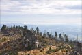 view gallery view galleryNE14 km |  Hochstein - Freyung-Grafenau - Bayern - Germany Hochstein - Freyung-Grafenau - Bayern - Germany
in Scenic Overlooks The "Hochstein" (alt. 1333m) is a cluster of granite blocks on the highest spot of the mountain "Dreisessel" in Bavaria.
Der Hochstein (1333 m ü. NN) ist eine Granitfelsgruppe an der höchsten Stelle des Dreisesselbergs im Bayerischen Wald posted by: McGreifer location: Bayern, Germany date approved: 02/22/2016 last visited: never |
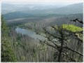
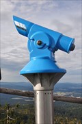 view gallery view galleryNE14 km |  BINO on the top of the "Hochstein"-BINO auf dem Hochstein BINO on the top of the "Hochstein"-BINO auf dem Hochstein
in Coin-Op Binoculars Awesome view from the top of the mountain "Hochstein" in the National Park "Bayrischer Wald". posted by: McGreifer location: Bayern, Germany date approved: 10/06/2015 last visited: 03/04/2018 |
 view gallery view galleryNE14.2 km |  TB 3904-1 V reservaci TB 3904-1 V reservaci
in Czech Geodetic Points Trigonometrický bod na vrchu Vysoký hreben posted by: pavlikVB location: Jihočeský kraj, Czechia date approved: 05/06/2009 last visited: never |
 view gallery view galleryNE15.4 km | TB 3903-14 Spicak in Czech Geodetic Points Trigonometrický bod na Šumavské tisícovce posted by: pavlikVB location: Jihočeský kraj, Czechia date approved: 05/11/2009 last visited: 08/19/2011 |
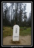 view gallery view gallery E15.8 km E15.8 km
|  Trojmezí/ Three Borders (tripont) Trojmezí/ Three Borders (tripont)
in European Historic Survey Stones, Monuments and Benchmarks Trojmezí (Dreieckmark). Místo, kde se setkávají hranice CR, Rakouska a SRN/ Three Borders (Dreieckmark). The place where the borders meet Republic, Austria and Germany. posted by: Waupe location: Jihočeský kraj, Czechia date approved: 01/28/2011 last visited: 08/21/2020 |
 view gallery view galleryE15.8 km |  Trojmezí / Dreickenmark, Šumava - CZ, D, A Trojmezí / Dreickenmark, Šumava - CZ, D, A
in Tripoints and Multipoints Hranicní kámen v míste, kde se setkávají hranice trí zemí - Ceské republiky, Nemecka a Rakouska. /// Border stone on the tripoint of the Czech Republic (foreground), Austria and Germany. posted by: Ursus PiPa location: Jihočeský kraj, Czechia date approved: 03/12/2012 last visited: 08/21/2020 |
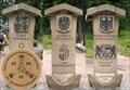 view gallery view galleryE15.8 km |  No. 1971, Cesko-Nemecko-Rakouské Trojmezí, CZ No. 1971, Cesko-Nemecko-Rakouské Trojmezí, CZ
in Tourist Stamps Photos Hranicní kámen v míste, kde se setkávají hranice trí zemí - Ceské republiky, Nemecka a Rakouska. /// Border stone on the tripoint of the Czech Republic (foreground), Austria and Germany. posted by: pavlikVB location: Jihočeský kraj, Czechia date approved: 05/01/2014 last visited: 08/21/2020 |
 view gallery view galleryNE16.7 km |  Nové Údolí/ Neuthal Nové Údolí/ Neuthal
in Ghost Towns Nové Údolí posted by: Waupe location: Jihočeský kraj, Czechia date approved: 10/28/2010 last visited: 05/16/2016 |
 view gallery view galleryE17.1 km |  Plechý - Šumava (Bohemian Forest / Böhmerwald) Mts. (Czech Republic) Plechý - Šumava (Bohemian Forest / Böhmerwald) Mts. (Czech Republic)
in Mountain Summits Plechý mountain (1 378 m) is the highest mountain of the Czech part of the Šumava mountains (Bohemian Forest). It lies 14 km west of the village Horní Planá and about 8 km south-west of the small village Nová Pec on the Czech-Austrian border. posted by: Dorcadion Team location: Jihočeský kraj, Czechia date approved: 05/27/2009 last visited: 08/21/2020 |
 view gallery view galleryE17.1 km | TB 3904-4 Plechy in Czech Geodetic Points Trigonometrický bod na hore Plechý posted by: pavlikVB location: Jihočeský kraj, Czechia date approved: 05/06/2009 last visited: 08/21/2020 |
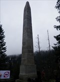 view gallery view galleryE17.2 km | TB 3904-2 Stifteruv pomnik in Czech Geodetic Points Trigonometrický bod nad Plešným jezerem posted by: pavlikVB location: Jihočeský kraj, Czechia date approved: 05/23/2010 last visited: 07/17/2016 |
 view gallery view galleryE17.2 km |  Plešné jezero, Šumava, CZ Plešné jezero, Šumava, CZ
in Natural Lakes Malebné horské jezero je jedním z osmi šumavských ledovcových jezer./// A picturesque mountain lake is One of the eight glacial kettle lakes in Šumava. posted by: Ursus PiPa location: Jihočeský kraj, Czechia date approved: 02/20/2012 last visited: 07/02/2016 |
 view gallery view galleryE19.3 km | TB 3904-3 Konsky vrch in Czech Geodetic Points Trigonometrický bod na Šumave posted by: pavlikVB location: Jihočeský kraj, Czechia date approved: 05/28/2012 last visited: never |
 view gallery view galleryE19.6 km | TB 3904-6 Studnicna in Czech Geodetic Points Trigonometrický bod na hore Studnicná posted by: pavlikVB location: Jihočeský kraj, Czechia date approved: 05/06/2009 last visited: 07/05/2013 |
 view gallery view galleryE20 km | No.1316, Rijište - Sumava, CZ in Tourist Stamps Photos CS: Malá šumavská slat / EN: Small moor of the Bohemian Forest posted by: pavlikVB location: Jihočeský kraj, Czechia date approved: 05/31/2012 last visited: never |
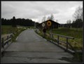
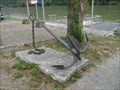 view gallery view gallery S20.1 km S20.1 km
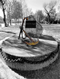
|  Kasten Anchor #1 Kasten Anchor #1
in Anchors Anchor on display in Kasten next to a ferry landing place. posted by: llavids location: Oberösterreich, Austria date approved: 08/15/2011 last visited: 08/28/2015 |
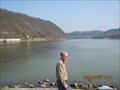 view gallery view gallery SW20.3 km SW20.3 km
|  CONFLUENCE: Inn and Danube - Bayern, Deutschland CONFLUENCE: Inn and Danube - Bayern, Deutschland
in River Origins, Destinations and Confluences Drei-Flüsse-Stadt Passau posted by: *Team Krombaer* location: Bayern, Germany date approved: 03/26/2012 last visited: 07/18/2018 |
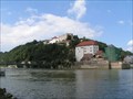 view gallery view gallerySW20.3 km |  Veste Oberhaus - Passau, Bayern, D Veste Oberhaus - Passau, Bayern, D
in Wikipedia Entries Veste Oberhaus in Passau posted by: lumbricus location: Bayern, Germany date approved: 02/11/2012 last visited: 07/18/2018 |
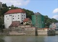 view gallery view gallerySW20.3 km | Veste Niederhaus - Passau, Bayern, D in Wikipedia Entries Veste Niederhaus in Passau. posted by: lumbricus location: Bayern, Germany date approved: 02/11/2012 last visited: 03/22/2018 |
 view gallery view gallerySW20.3 km | Anker am Dreiflußeeck Passau - BY - Germany in Anchors Hier treffen sich Donau, Inn und Ilz posted by: die_sonnenkoeppe location: Bayern, Germany date approved: 11/25/2016 last visited: 07/13/2021 |
 view gallery view gallerySW20.3 km |  Stone labyrinth, Passau, Germany Stone labyrinth, Passau, Germany
in Outdoor Mazes Stone labyrinth on the tip of the Passau Peninsula at the confluence of the rivers Danube, Inn and Ilz. posted by: André de Montbard location: Bayern, Germany date approved: 09/14/2015 last visited: never |
|