 view gallery view gallery NE8.4 km NE8.4 km
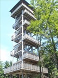
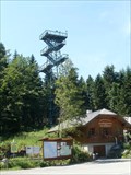
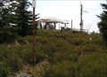
|   Alpenblick, Ulrichsberg , Austria Alpenblick, Ulrichsberg , Austria
in Look-Out Towers Wooden look-out tower with a view of the Upper Austria. posted by:  Arne1 Arne1 location: Oberösterreich, Austria date approved: 07/17/2013 last visited: never |
 view gallery view gallery E8.7 km E8.7 km
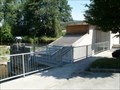
|  Stift Schlaegel - Schlaegl, OO, Austria Stift Schlaegel - Schlaegl, OO, Austria
in Hydroelectric Power Stations [EN]Small hydro power plant with interesting combination of Kaplan turbines and screw.
[DE]Kleinwasserkraftwerk mit interessante Kombination von Kaplan Turbinen und Schnecke. posted by: Arne1 location: Oberösterreich, Austria date approved: 07/16/2013 last visited: never |
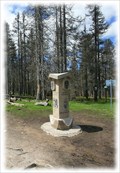
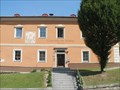 view gallery view galleryE8.7 km |  Gemeindeamt Schlägl, Austria Gemeindeamt Schlägl, Austria
in Sundials Sundial on the wall of Authority in Schlägl near the abbey in Upper Austria. posted by: Arne1 location: Niederösterreich, Austria date approved: 07/16/2013 last visited: never |
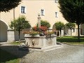 view gallery view galleryE8.7 km |  Monastery Schlägl, Austria Monastery Schlägl, Austria
in Fountains Fountain with fish in the Upper Austria monastery Schlägl posted by: Arne1 location: Oberösterreich, Austria date approved: 07/15/2013 last visited: never |
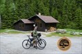
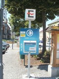 view gallery view galleryE9 km |  Marktplatz in Aigen im Mühlkreis, Austria Marktplatz in Aigen im Mühlkreis, Austria
in Electric Car Charging Stations [DE] Ladestation auf dem Marktplatz in Aigen, OO
[EN] Electric charging station on Square in Aigen, Upper Austria posted by: Arne1 location: Oberösterreich, Austria date approved: 07/16/2013 last visited: never |
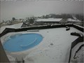 view gallery view galleryE9 km |  Live Cam Hotel Almesberger - Oberösterreich / Austria Live Cam Hotel Almesberger - Oberösterreich / Austria
in Web Cameras Live Cam shows the swimming pool of the hotel posted by: Iris & Harry location: Oberösterreich, Austria date approved: 01/31/2017 last visited: never |
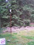
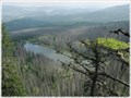
 view gallery view galleryNE10.6 km | Moldaublick, Ulrichsberg , Austria in Look-Out Towers Metal look-out tower with a view of the Lipno Lake and surroundings on Czech territory. posted by: Arne1 location: Oberösterreich, Austria date approved: 07/17/2013 last visited: never |
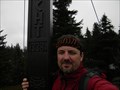 view gallery view galleryNE10.9 km |  Kríž na vrcholu hory Hochficht/The cross on the top mountain Hochficht Kríž na vrcholu hory Hochficht/The cross on the top mountain Hochficht
in Christian Crosses CZ: Kríž na vrcholu hory Hochficht
EN: The cross on the top mountain Hochficht posted by:  Waupe Waupe location: Oberösterreich, Austria date approved: 10/07/2010 last visited: 08/26/2014 |
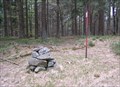
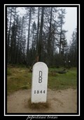
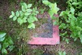
 view gallery view galleryNE10.9 km |  TB 4024-22 Smrcina TB 4024-22 Smrcina
in Czech Geodetic Points Trigonometrický bod na hore Smrcina posted by: pavlikVB location: Jihočeský kraj, Czechia date approved: 05/06/2009 last visited: 07/05/2013 |
 view gallery view gallery N12.6 km N12.6 km
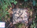
| TB 3904-6 Studnicna in Czech Geodetic Points Trigonometrický bod na hore Studnicná posted by: pavlikVB location: Jihočeský kraj, Czechia date approved: 05/06/2009 last visited: 07/05/2013 |
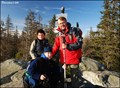 view gallery view galleryN13.5 km |  Plechý - Šumava (Bohemian Forest / Böhmerwald) Mts. (Czech Republic) Plechý - Šumava (Bohemian Forest / Böhmerwald) Mts. (Czech Republic)
in Mountain Summits Plechý mountain (1 378 m) is the highest mountain of the Czech part of the Šumava mountains (Bohemian Forest). It lies 14 km west of the village Horní Planá and about 8 km south-west of the small village Nová Pec on the Czech-Austrian border. posted by: Dorcadion Team location: Jihočeský kraj, Czechia date approved: 05/27/2009 last visited: 08/21/2020 |
 view gallery view galleryN13.5 km | TB 3904-4 Plechy in Czech Geodetic Points Trigonometrický bod na hore Plechý posted by: pavlikVB location: Jihočeský kraj, Czechia date approved: 05/06/2009 last visited: 08/21/2020 |
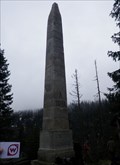
 view gallery view galleryN13.5 km |  Trojmezí/ Three Borders (tripont) Trojmezí/ Three Borders (tripont)
in European Historic Survey Stones, Monuments and Benchmarks Trojmezí (Dreieckmark). Místo, kde se setkávají hranice CR, Rakouska a SRN/ Three Borders (Dreieckmark). The place where the borders meet Republic, Austria and Germany. posted by: Waupe location: Jihočeský kraj, Czechia date approved: 01/28/2011 last visited: 08/21/2020 |
 view gallery view galleryN13.5 km |  Trojmezí / Dreickenmark, Šumava - CZ, D, A Trojmezí / Dreickenmark, Šumava - CZ, D, A
in Tripoints and Multipoints Hranicní kámen v míste, kde se setkávají hranice trí zemí - Ceské republiky, Nemecka a Rakouska. /// Border stone on the tripoint of the Czech Republic (foreground), Austria and Germany. posted by: Ursus PiPa location: Jihočeský kraj, Czechia date approved: 03/12/2012 last visited: 08/21/2020 |
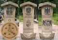 view gallery view galleryN13.5 km |  No. 1971, Cesko-Nemecko-Rakouské Trojmezí, CZ No. 1971, Cesko-Nemecko-Rakouské Trojmezí, CZ
in Tourist Stamps Photos Hranicní kámen v míste, kde se setkávají hranice trí zemí - Ceské republiky, Nemecka a Rakouska. /// Border stone on the tripoint of the Czech Republic (foreground), Austria and Germany. posted by: pavlikVB location: Jihočeský kraj, Czechia date approved: 05/01/2014 last visited: 08/21/2020 |
 view gallery view galleryE13.8 km | TB 4025-4 Kozi stran in Czech Geodetic Points Trigonometrický bod asi 350m od státní hranice s AUT posted by: pavlikVB location: Jihočeský kraj, Czechia date approved: 10/03/2010 last visited: never |
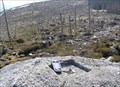
 view gallery view galleryN14 km |  Plešné jezero, Šumava, CZ Plešné jezero, Šumava, CZ
in Natural Lakes Malebné horské jezero je jedním z osmi šumavských ledovcových jezer./// A picturesque mountain lake is One of the eight glacial kettle lakes in Šumava. posted by: Ursus PiPa location: Jihočeský kraj, Czechia date approved: 02/20/2012 last visited: 07/02/2016 |
 view gallery view galleryN14.2 km | TB 3904-2 Stifteruv pomnik in Czech Geodetic Points Trigonometrický bod nad Plešným jezerem posted by: pavlikVB location: Jihočeský kraj, Czechia date approved: 05/23/2010 last visited: 07/17/2016 |
 view gallery view galleryN14.2 km | TB 3904-1 V reservaci in Czech Geodetic Points Trigonometrický bod na vrchu Vysoký hreben posted by: pavlikVB location: Jihočeský kraj, Czechia date approved: 05/06/2009 last visited: never |
 view gallery view galleryN14.2 km | No.1316, Rijište - Sumava, CZ in Tourist Stamps Photos CS: Malá šumavská slat / EN: Small moor of the Bohemian Forest posted by: pavlikVB location: Jihočeský kraj, Czechia date approved: 05/31/2012 last visited: never |
 view gallery view galleryN15.1 km | TB 3904-3 Konsky vrch in Czech Geodetic Points Trigonometrický bod na Šumave posted by: pavlikVB location: Jihočeský kraj, Czechia date approved: 05/28/2012 last visited: never |
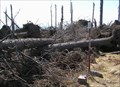
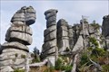 view gallery view galleryN15.3 km |  Wollsackverwitterung am Hochstein - Bayern - Germany Wollsackverwitterung am Hochstein - Bayern - Germany
in Places of Geologic Significance Impressive rock formation next to the walking track towards the "Hochstein"
Beeindruckende Felsformation neben dem Fußweg zum Hochstein posted by: McGreifer location: Bayern, Germany date approved: 02/22/2016 last visited: never |
 view gallery view galleryE15.3 km | TB 4025-6 Kyselovsky les in Czech Geodetic Points Trigonometrický bod u Lipenské nádrže posted by: pavlikVB location: Jihočeský kraj, Czechia date approved: 07/17/2011 last visited: 07/20/2011 |
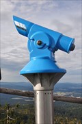 view gallery view galleryN15.4 km |  BINO on the top of the "Hochstein"-BINO auf dem Hochstein BINO on the top of the "Hochstein"-BINO auf dem Hochstein
in Coin-Op Binoculars Awesome view from the top of the mountain "Hochstein" in the National Park "Bayrischer Wald". posted by: McGreifer location: Bayern, Germany date approved: 10/06/2015 last visited: 03/04/2018 |
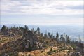 view gallery view galleryN15.4 km |  Hochstein - Freyung-Grafenau - Bayern - Germany Hochstein - Freyung-Grafenau - Bayern - Germany
in Scenic Overlooks The "Hochstein" (alt. 1333m) is a cluster of granite blocks on the highest spot of the mountain "Dreisessel" in Bavaria.
Der Hochstein (1333 m ü. NN) ist eine Granitfelsgruppe an der höchsten Stelle des Dreisesselbergs im Bayerischen Wald posted by: McGreifer location: Bayern, Germany date approved: 02/22/2016 last visited: never |
|