 view gallery view gallery W15 km W15 km
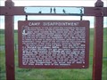
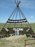
|   CAMP DISAPPOINTMENT CAMP DISAPPOINTMENT
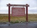
in Lewis and Clark Trail CAMP DISAPPOINTMENT "NORTHERNMOST" CAMP SITE OF LEWIS EXPEDITION. posted by:  GEO*Trailblazer 1 GEO*Trailblazer 1 location: Montana date approved: 11/15/2006 last visited: 11/15/2006 |
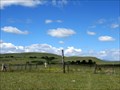
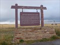
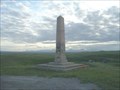 view gallery view galleryW15.1 km |  LEWIS AND CLARK EXPEDITION MONUMENT LEWIS AND CLARK EXPEDITION MONUMENT
in U.S. Historic Survey Stones and Monuments Designation: LEWIS AND CLARK EXPEDITION MONUMENT.
Marker Type: NGS Benchmark.
Setting: setting not listed - see long description.
Stability: posted by: GEO*Trailblazer 1 location: Montana date approved: 08/22/2006 last visited: 08/22/2006 |
 view gallery view gallery SW16.1 km SW16.1 km
|  Holy Family Mission Cemetery - Browning, Montana Holy Family Mission Cemetery - Browning, Montana
in Worldwide Cemeteries Holy Family Mission Cemetery is just east of the Mission on Joe Show East Road about 24 km SE of Browning off Hwy. 89. posted by:  T0SHEA T0SHEA location: Montana date approved: 01/26/2018 last visited: never |
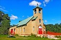
 view gallery view gallerySW16.4 km |  Holy Family Mission - Browning, MT Holy Family Mission - Browning, MT
in U.S. National Register of Historic Places A Catholic Mission from 1886 to 1940, a once large complex of mission buildings has been reduced to a 1937 brick church, a cemetery and a nearly non-extant wood framed barn. posted by: T0SHEA location: Montana date approved: 02/12/2023 last visited: never |
 view gallery view gallerySW16.4 km |  Holy Family Mission - Browning, MT Holy Family Mission - Browning, MT
in Country Churches A Catholic Mission from 1886 to 1940, a once large complex of mission buildings has been reduced to a 1937 brick church, a cemetery and a nearly non-extant wood framed barn. posted by: T0SHEA location: Missouri date approved: 03/23/2023 last visited: never |
 view gallery view gallerySW16.4 km |  Holy Family Mission (Glacier County, Montana) Holy Family Mission (Glacier County, Montana)
in Wikipedia Entries A Catholic Mission from 1886 to 1940, a once large complex of mission buildings has been reduced to a 1937 brick church, a cemetery and a nearly non-extant wood framed barn. posted by: T0SHEA location: Montana date approved: 03/22/2023 last visited: never |
 view gallery view gallerySW16.4 km | Holy Family Mission - Browning, MT in Roman Catholic Churches A Catholic Mission from 1886 to 1940, a once large complex of mission buildings has been reduced to a 1937 brick church, a cemetery and a nearly non-extant wood framed barn. posted by: T0SHEA location: Montana date approved: 03/23/2023 last visited: never |
 view gallery view gallerySW16.4 km |  Holy Family Mission - Browning, MT Holy Family Mission - Browning, MT
in Victorian Style Architecture A Catholic Mission from 1886 to 1940, a once large complex of mission buildings has been reduced to a 1937 brick church, a cemetery and a nearly non-extant wood framed barn. posted by: T0SHEA location: Montana date approved: 03/22/2023 last visited: never |
 view gallery view gallerySW16.4 km |  Holy Family Mission - Browning, MT Holy Family Mission - Browning, MT
in Montana Historical Markers A Catholic Mission from 1886 to 1940, a once large complex of mission buildings has been reduced to a 1937 brick church, a cemetery and a nearly non-extant wood framed barn. posted by: T0SHEA location: Montana date approved: 03/22/2023 last visited: never |
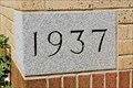 view gallery view gallerySW16.4 km |  1937 - Holy Family Mission - Browning, MT 1937 - Holy Family Mission - Browning, MT
in Dated Buildings and Cornerstones A Catholic Mission from 1886 to 1940, a once large complex of mission buildings has been reduced to a 1937 brick church, a cemetery and a nearly non-extant wood framed barn. posted by: T0SHEA location: Montana date approved: 03/22/2023 last visited: never |
 view gallery view gallerySW16.4 km |  Holy Family Mission - Browning, MT Holy Family Mission - Browning, MT
in Bell Towers A Catholic Mission from 1886 to 1940, a once large complex of mission buildings has been reduced to a 1937 brick church, a cemetery and a nearly non-extant wood framed barn. posted by: T0SHEA location: Montana date approved: 03/22/2023 last visited: never |
 view gallery view gallerySW19.3 km | Old Agency - Piegan, MT in Montana Historical Markers Just east of the White Man Creek Bridge on Highway 89, this Montana Historical Highway Marker stands at a large pullout on the north side of the highway. Just to the east is the settlement of Piegan. posted by: T0SHEA location: Montana date approved: 08/06/2017 last visited: 08/03/2022 |
 view gallery view gallery E19.3 km E19.3 km
|  McDonalds Free WiFi ~ Cut Bank, Montana McDonalds Free WiFi ~ Cut Bank, Montana
in Wi-Fi Hotspots Free WiFi Served Daily at the McDonalds located at 601 W Main Street in Cut Bank, Montana. posted by: brwhiz location: Montana date approved: 01/21/2013 last visited: 07/18/2017 |
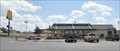
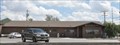
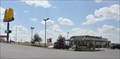 view gallery view galleryE19.3 km |  McDonalds ~ Cut Bank, Montana McDonalds ~ Cut Bank, Montana
in McDonald's Restaurants This McDonald's is located at 601 W Main Street in Cut Bank, Montana. posted by: brwhiz location: Montana date approved: 01/22/2013 last visited: 05/25/2019 |
 view gallery view galleryE19.6 km |  Cut Bank, Montana 59427 Cut Bank, Montana 59427
in U.S. Post Offices This Post Office is located at 37 S Central Avenue in Cut Bank, Montana. posted by: brwhiz location: Montana date approved: 01/30/2013 last visited: 01/09/2015 |
 view gallery view gallery SE20.9 km SE20.9 km
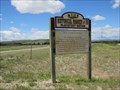
| TWO MEDICINE FIGHT SITE in Lewis and Clark Trail TWO MEDICINE FIGHT SITE MONTANA posted by: GEO*Trailblazer 1 location: Montana date approved: 11/15/2006 last visited: 11/15/2006 |
 view gallery view gallerySW21.6 km | Four Horns Cemetery - Piegan, Montana in Worldwide Cemeteries Four Horns Cemetery is in Blackfoot Country, and on private property. You can access the cemetery from Hwy. 89. There is a gate to enter, dirt road is very rough and goes up a steep hill. Be a good cowboy and close the gate behind you. posted by: T0SHEA location: Montana date approved: 01/26/2018 last visited: never |
 view gallery view galleryW29.3 km |  Browning Southeast Webcam - Browning, MT Browning Southeast Webcam - Browning, MT
in Web Cameras This is one of 73 (as of January 2017) Road Weather Information System cameras operated by the Montana Department of Transportation to aid motorists as they make their way across BIG SKY Country. posted by: T0SHEA location: Montana date approved: 01/11/2017 last visited: never |
 view gallery view galleryW29.3 km | Browning Roadway Webcam - Browning, MT in Web Cameras This is one of 73 (as of January 2017) Road Weather Information System cameras operated by the Montana Department of Transportation to aid motorists as they make their way across BIG SKY Country. posted by: T0SHEA location: Montana date approved: 01/11/2017 last visited: never |
 view gallery view galleryW29.3 km | Browning Northwest Webcam - Browning, MT in Web Cameras This is one of 73 (as of January 2017) Road Weather Information System cameras operated by the Montana Department of Transportation to aid motorists as they make their way across BIG SKY Country. posted by: T0SHEA location: Montana date approved: 01/11/2017 last visited: never |
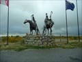 view gallery view gallery S29.3 km S29.3 km
|  Welcoming Warriors - Blackfeet Nation - Valier MT Welcoming Warriors - Blackfeet Nation - Valier MT
in Figurative Public Sculpture Located on US 89 in Valier MT posted by: nomadwillie location: Montana date approved: 06/29/2011 last visited: 02/18/2018 |
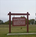
 view gallery view galleryS30.3 km | Captain Meriweather Lewis in Montana Historical Markers Located on US 89 in Valier, MT posted by: nomadwillie location: Montana date approved: 06/29/2011 last visited: 08/03/2022 |
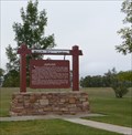
 view gallery view galleryS30.3 km | Chief Mountain / Old North Trail in Montana Historical Markers Located on a turnout on US 89 in Valier MT posted by: nomadwillie location: Montana date approved: 06/29/2011 last visited: 08/03/2022 |
 view gallery view galleryS30.3 km | Dupuyer in Montana Historical Markers Located on US 89 in Valier MT. There are 2 markers at this site. posted by: nomadwillie location: Montana date approved: 06/30/2011 last visited: 09/21/2010 |
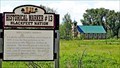
 view gallery view galleryW30.6 km | The Blackfeet Nation in Montana Historical Markers Located on US 2 outside of Browning MT posted by: nomadwillie location: Montana date approved: 06/29/2011 last visited: 08/03/2022 |
|