 view gallery view gallery E4.5 km E4.5 km
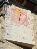
|   Cadran solaire de l'église, Bivilliers, France. Cadran solaire de l'église, Bivilliers, France.
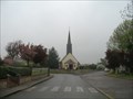
in Sundials [FR] Ce cadran solaire se trouve à Bivilliers dans le département de l'Orne.
[EN] This sundial is located in Bivilliers in the Orne department. posted by:  junkys junkys location: Normandie, France date approved: 01/22/2019 last visited: never |
 view gallery view gallery S7.1 km S7.1 km
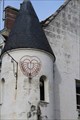
| Cadran Solaire - Maison à tourelle - Mortagne-au-Perche, France in Sundials [EN] This sundial is located in Mortagne-au-Perche in the Orne department.
[FR] Ce cadran solaire se trouve à Mortagne-au-Perche dans le département de l'Orne. posted by: pmaupin location: Centre-Val-de-Loire, France date approved: 03/13/2018 last visited: 02/25/2017 |
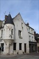 view gallery view galleryS7.1 km |  La Maison à tourelle - Mortagne-au-Perche, France La Maison à tourelle - Mortagne-au-Perche, France
in Monuments Historiques Français [FR] La maison à tourelle, du XVIème siècle, fût jadis une auberge.
[EN] The turreted house of the sixteenth century was once an inn. posted by: pmaupin location: Centre-Val-de-Loire, France date approved: 03/17/2018 last visited: 02/25/2017 |
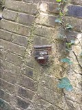
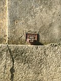
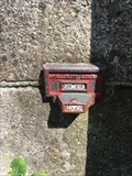
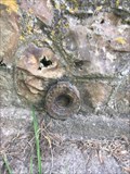
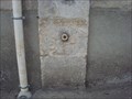
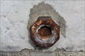 view gallery view galleryS7.1 km |  Benchmark - Anciennes Halles - Mortagne-au Perche, France Benchmark - Anciennes Halles - Mortagne-au Perche, France
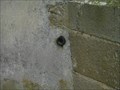
in French Benchmarks Le Repère MRU (Ministère Reconstruction Urbanisme) se situe sur le mur pignon Sud-Ouest des anciennes halles, face à la mairie. posted by: pmaupin location: Normandie, France date approved: 03/14/2017 last visited: 02/25/2017 |
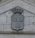 view gallery view galleryS7.1 km |  Blason de la Ville de Mortagne au Perche - Mortagne au Perche, France Blason de la Ville de Mortagne au Perche - Mortagne au Perche, France
in Coats of Arms [EN] Coat of arms of the city of Mortagne au Perche above the entrance of the town hall.
[FR] Blason de la ville de Mortagne au Perche au-dessus de la porte d'entrée de l'hôtel de ville. posted by: pmaupin location: Normandie, France date approved: 03/14/2017 last visited: 02/25/2017 |
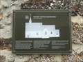 view gallery view galleryE10.6 km | Eglise Sainte Madeleine - La Ventrouze, France in Monuments Historiques Français [En] Small rural building of the late 15th century.
[Fr] Petit édifice rural de la fin du 15e siècle. posted by: geotrouvtou59 location: Normandie, France date approved: 05/08/2018 last visited: 05/09/2018 |
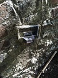
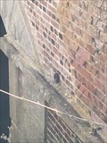
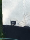
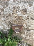
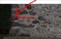 view gallery view galleryE10.6 km | Benchmark Eglise de la Ventrouze in French Benchmarks Repère sur le mur du pignon antérieur Sud-Ouest posted by: geotrouvtou59 location: Normandie, France date approved: 05/08/2018 last visited: 05/08/2018 |
 view gallery view galleryS14.3 km | T.D.M3 - 145 in French Benchmarks C REPERE CONSOLE posted by: keillec location: Normandie, France date approved: 04/23/2019 last visited: 04/21/2019 |
 view gallery view galleryS14.6 km | STATION DE "MAUVES-CORBON" (T.D.M3 - 146) in French Benchmarks C REPERE CONSOLE posted by: keillec location: Normandie, France date approved: 04/23/2019 last visited: 04/21/2019 |
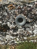
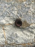 view gallery view galleryS15.6 km | Repère de Nivellement - Église Saint-Pierre - Mauves-sur-Huisne, France in French Benchmarks M REPERE CYLINDRIQUE DU NIVELLEMENT GENERAL posted by: keillec location: Normandie, France date approved: 04/23/2019 last visited: 04/21/2019 |
 view gallery view galleryS15.6 km | Repère Géodésique - Église Saint-Pierre - Mauves-sur-Huisne, France in French Benchmarks Site du Réseau de détail posted by: keillec location: France date approved: 04/23/2019 last visited: 04/21/2019 |
 view gallery view galleryS16.1 km | LA BISSONNIERE (T.D.M3 - 148) in French Benchmarks repere non trouve en 2002 mais bien present. posted by: keillec location: Normandie, France date approved: 04/24/2019 last visited: 04/24/2019 |
 view gallery view gallery SE16.6 km SE16.6 km
| LE MOULIN DE LA VOVE (T.D.M3 - 48) in French Benchmarks M REPERE CYLINDRIQUE DU NIVELLEMENT GENERAL posted by: keillec location: Normandie, France date approved: 04/24/2019 last visited: 04/24/2019 |
 view gallery view galleryE18.8 km | Repère de nivellement - Église Notre-Dame-de-l'Assomption (T.C.L3P3 - 13a) - Marchainville, France in French Benchmarks M REPERE CYLINDRIQUE DU NIVELLEMENT GENERAL
Ce repère appartient à un triplet.
Liste des repères du triplet : T.C.L3P3 - 13 , T.C.L3P3 - 13a , T.C.L3P3 - 14 , T.C.L3P3 - 15 posted by: keillec location: Normandie, France date approved: 04/23/2019 last visited: 04/21/2019 |
 view gallery view gallery NE19.5 km NE19.5 km
| Benchmark Eglise de Saint-Ouen-sur-Iton in French Benchmarks Repère sur le Mur de façade latéral nord de la Nef. posted by: geotrouvtou59 location: Normandie, France date approved: 05/07/2018 last visited: 05/08/2018 |
 view gallery view galleryNE19.5 km | Benchmark Géodésique SAINT-OUEN-SUR-ITON A in French Benchmarks Repere Centre de la croix de l'Eglise de SAINT-OUEN-SUR-ITON posted by: geotrouvtou59 location: Normandie, France date approved: 05/07/2018 last visited: 05/08/2018 |
 view gallery view gallerySE20.1 km | PONT SUR LA RIVIERE "L'HUISNE" (T.D.M3 - 154) in French Benchmarks mauvaise coordonnees sur le site de geodesie.
et non retrouve en 1984 posted by: keillec location: Normandie, France date approved: 04/24/2019 last visited: 04/24/2019 |
 view gallery view gallerySE21.2 km | la maisonnette (T.D.M3 - 155) in French Benchmarks C REPERE CONSOLE posted by: keillec location: Normandie, France date approved: 04/24/2019 last visited: 04/24/2019 |
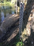 view gallery view gallerySE25.6 km | PONT DE DORCEAU echelle hydrometrique (B) in French Benchmarks echelle hydrometrique posted by: keillec location: Normandie, France date approved: 05/07/2019 last visited: 04/24/2019 |
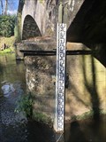 view gallery view gallerySE25.6 km | PONT DE DORCEAU echelle hydrometrique (A) in French Benchmarks echelle hydrometrique posted by: keillec location: Normandie, France date approved: 05/07/2019 last visited: 04/24/2019 |
 view gallery view gallerySE25.6 km | PONT DE DORCEAU (T.D.M3 - 168) in French Benchmarks M REPERE CYLINDRIQUE DU NIVELLEMENT GENERAL posted by: keillec location: Normandie, France date approved: 04/24/2019 last visited: 04/24/2019 |
 view gallery view galleryNE25.6 km |  Golf des Bois Franc Center-Parc - Verneuil-sur-Avre, France Golf des Bois Franc Center-Parc - Verneuil-sur-Avre, France
in Public and Private Golf Courses [FR] Golf de Center parc à coté du parc, Verneuil-sur-Avre.
[EN] Center park's golf next to the park, Verneuil-sur-Avre. posted by:  AlexEmilie AlexEmilie location: Normandie, France date approved: 02/26/2017 last visited: never |
 view gallery view gallerySE28.3 km | PONT SUR LA RIVIERE "L'HUISNE" (T.D.M3 - 161) in French Benchmarks C REPERE CONSOLE posted by: keillec location: Normandie, France date approved: 04/24/2019 last visited: 04/24/2019 |
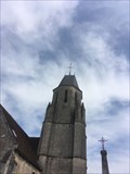
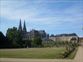 view gallery view gallery W28.5 km W28.5 km
| Réseau géodésique de Sées in French Benchmarks Clocher de la cathédrale posted by: lulu_et_compagnie location: Normandie, France date approved: 11/27/2013 last visited: 01/22/2019 |
 view gallery view galleryW28.5 km | Benchmarks Cathédrale de Sées in French Benchmarks Sur la cathédrale. posted by: lulu_et_compagnie location: Normandie, France date approved: 08/20/2013 last visited: 11/28/2014 |
|