 view gallery view gallery NE6.9 km NE6.9 km
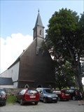
|   Monastery Schlägl, Austria Monastery Schlägl, Austria
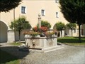
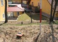
in Fountains Fountain with fish in the Upper Austria monastery Schlägl posted by:  Arne1 Arne1 location: Oberösterreich, Austria date approved: 07/15/2013 last visited: never |
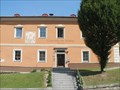
 view gallery view galleryNE6.9 km |  Stift Schlaegel - Schlaegl, OO, Austria Stift Schlaegel - Schlaegl, OO, Austria
in Hydroelectric Power Stations [EN]Small hydro power plant with interesting combination of Kaplan turbines and screw.
[DE]Kleinwasserkraftwerk mit interessante Kombination von Kaplan Turbinen und Schnecke. posted by: Arne1 location: Oberösterreich, Austria date approved: 07/16/2013 last visited: never |
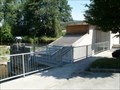
 view gallery view galleryNE7.1 km |  Gemeindeamt Schlägl, Austria Gemeindeamt Schlägl, Austria
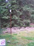
in Sundials Sundial on the wall of Authority in Schlägl near the abbey in Upper Austria. posted by: Arne1 location: Niederösterreich, Austria date approved: 07/16/2013 last visited: never |
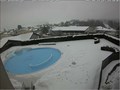 view gallery view galleryNE8 km |  Live Cam Hotel Almesberger - Oberösterreich / Austria Live Cam Hotel Almesberger - Oberösterreich / Austria
in Web Cameras Live Cam shows the swimming pool of the hotel posted by: Iris & Harry location: Oberösterreich, Austria date approved: 01/31/2017 last visited: never |
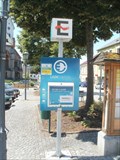 view gallery view galleryNE8 km |  Marktplatz in Aigen im Mühlkreis, Austria Marktplatz in Aigen im Mühlkreis, Austria
in Electric Car Charging Stations [DE] Ladestation auf dem Marktplatz in Aigen, OO
[EN] Electric charging station on Square in Aigen, Upper Austria posted by: Arne1 location: Oberösterreich, Austria date approved: 07/16/2013 last visited: never |
 view gallery view gallery E11.6 km E11.6 km
|  TB 5321-3 U Horní Ureše TB 5321-3 U Horní Ureše
in Czech Geodetic Points Trigonometrický bod na státní hranici s AUT posted by: pavlikVB location: Jihočeský kraj, Czechia date approved: 06/05/2020 last visited: never |
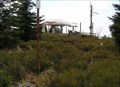
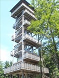 view gallery view gallery N12.6 km N12.6 km
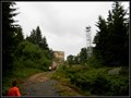
|  Alpenblick, Ulrichsberg , Austria Alpenblick, Ulrichsberg , Austria
in Look-Out Towers Wooden look-out tower with a view of the Upper Austria. posted by: Arne1 location: Oberösterreich, Austria date approved: 07/17/2013 last visited: never |
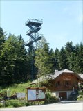 view gallery view galleryN13.8 km | Moldaublick, Ulrichsberg , Austria in Look-Out Towers Metal look-out tower with a view of the Lipno Lake and surroundings on Czech territory. posted by: Arne1 location: Oberösterreich, Austria date approved: 07/17/2013 last visited: never |
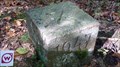
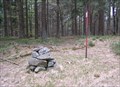
 view gallery view galleryNE14.6 km | TB 4025-4 Kozi stran in Czech Geodetic Points Trigonometrický bod asi 350m od státní hranice s AUT posted by: pavlikVB location: Jihočeský kraj, Czechia date approved: 10/03/2010 last visited: never |
 view gallery view galleryNE15.1 km | TB 4025-6 Kyselovsky les in Czech Geodetic Points Trigonometrický bod u Lipenské nádrže posted by: pavlikVB location: Jihočeský kraj, Czechia date approved: 07/17/2011 last visited: 07/20/2011 |
 view gallery view galleryNE15.3 km |  Kostel Kristova Utrpení - Svatý Tomáš, Czech Republic Kostel Kristova Utrpení - Svatý Tomáš, Czech Republic
in Roman Catholic Churches [CZ]: Gotický bývalý farní a poutní kostel v obci Svatý Tomáš byl postaven roku 1348 na príkaz Petra I. z Rožmberka.
[EN]: Gothic, former parish and pilgrimage church in village called Svatý Tomáš was built in 1348 by order of Peter I. of Rosenberg. posted by:  alreadyhere alreadyhere location: Jihočeský kraj, Czechia date approved: 08/18/2014 last visited: 04/19/2019 |
 view gallery view galleryNE15.3 km |  Little Castle "Vítkuv Hrádek" Little Castle "Vítkuv Hrádek"
in Preserved Architectural Remnants and Ruins Little Castle "Vítkuv Hrádek" posted by: Waupe location: Jihočeský kraj, Czechia date approved: 01/04/2011 last visited: 07/25/2016 |
 view gallery view galleryE15.6 km | TB 4020-24 Svaty Tomas jv. in Czech Geodetic Points Trigonometrický bod nad Lipenskou nádrží posted by: pavlikVB location: Jihočeský kraj, Czechia date approved: 09/30/2014 last visited: never |
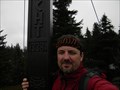 view gallery view galleryN17.1 km |  Kríž na vrcholu hory Hochficht/The cross on the top mountain Hochficht Kríž na vrcholu hory Hochficht/The cross on the top mountain Hochficht
in Christian Crosses CZ: Kríž na vrcholu hory Hochficht
EN: The cross on the top mountain Hochficht posted by: Waupe location: Oberösterreich, Austria date approved: 10/07/2010 last visited: 08/26/2014 |
 view gallery view galleryE17.1 km | TB 5316-11 Multerberske pastviny in Czech Geodetic Points Trigonometrický bod u hranic s Rakouskem posted by: pavlikVB location: Jihočeský kraj, Czechia date approved: 04/28/2010 last visited: never |
 view gallery view galleryN17.1 km | TB 4024-22 Smrcina in Czech Geodetic Points Trigonometrický bod na hore Smrcina posted by: pavlikVB location: Jihočeský kraj, Czechia date approved: 05/06/2009 last visited: 07/05/2013 |
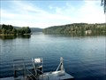 view gallery view galleryNE17.2 km |  LARGEST -- water reservoir in Czech Rep., Lipno, Czech Republic LARGEST -- water reservoir in Czech Rep., Lipno, Czech Republic
in Superlatives Lake Lipno as South Bohemian Sea posted by: ToRo61 location: Jihočeský kraj, Czechia date approved: 10/08/2011 last visited: 06/12/2018 |
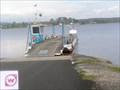 view gallery view galleryNE17.2 km |  Dolni Vltavice - Kyselov Ferry, CZE Dolni Vltavice - Kyselov Ferry, CZE
in Ferries and Ferry Landings Nejdelší prívoz v Ceské Republice / The longest ferry in the Czech Republic posted by: pavlikVB location: Jihočeský kraj, Czechia date approved: 10/11/2010 last visited: 08/08/2017 |
 view gallery view galleryNE17.2 km |  Anchor, Dolni Vltavice, Lipno, CZE Anchor, Dolni Vltavice, Lipno, CZE
in Anchors Kotva na brehu Lipenské vodní nádrže / Anchor on the shore of the Lipno dam posted by: pavlikVB location: Jihočeský kraj, Czechia date approved: 10/03/2010 last visited: 08/08/2017 |
 view gallery view galleryNE17.5 km | TB 4020-6 Josefinus, Cerná v Pošumaví (CK) in Czech Geodetic Points Trigonomerický bod 4020-6.0 je na vrchu táhlé kupy v severovýchodním okraji osady Dolní Vltavice. posted by: torfik location: Jihočeský kraj, Czechia date approved: 09/16/2010 last visited: 08/08/2017 |
 view gallery view galleryNE18.2 km | TB 4020-11 Kovárov jz. in Czech Geodetic Points Trigonometrický bod nad nádrží Lipno posted by: pavlikVB location: Jihočeský kraj, Czechia date approved: 06/05/2020 last visited: never |
 view gallery view galleryE18.8 km | TB 5316-13 U celnice in Czech Geodetic Points Trigonometrický bod 3m od hranicního patníku posted by: pavlikVB location: Jihočeský kraj, Czechia date approved: 04/12/2009 last visited: never |
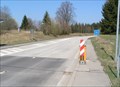 view gallery view galleryE19.2 km |  Prední Výton (CZE) - Guglwald (AUT) Prední Výton (CZE) - Guglwald (AUT)
in Border Crossings Little border crossing for every road transport posted by: pavlikVB location: Jihočeský kraj, Czechia date approved: 09/27/2009 last visited: 05/09/2016 |
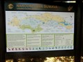 view gallery view galleryNE19.3 km |  Sumava National Park, Czech Republic Sumava National Park, Czech Republic
in National Parks of the World Šumava - Green Heart of Europe posted by: ToRo61 location: Jihočeský kraj, Czechia date approved: 10/05/2011 last visited: 08/03/2020 |
 view gallery view galleryN19.5 km | TB 3904-6 Studnicna in Czech Geodetic Points Trigonometrický bod na hore Studnicná posted by: pavlikVB location: Jihočeský kraj, Czechia date approved: 05/06/2009 last visited: 07/05/2013 |
|