 view gallery view gallery SE1.1 km SE1.1 km
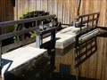
|   La vanne de La Hallière-Celle-sur-Plaine-Lorraine,France La vanne de La Hallière-Celle-sur-Plaine-Lorraine,France
in Historic Hand Operated Sluice Gates An important sluice gate for the sawmill! Une vanne importante pour la scierie! posted by:  gemeloj gemeloj location: Grand-Est, France date approved: 10/11/2014 last visited: 10/11/2014 |
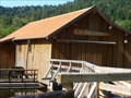 view gallery view gallerySE1.1 km |  Scierie La Hallière- Celle-sur-Plaine-Lorraine,France Scierie La Hallière- Celle-sur-Plaine-Lorraine,France
in Working Water Wheels The sawmill is the Hallière a mill in the village of Celles-sur-Plaine in the Vosges.La Scierie de la Hallière est une scierie située dans la commune de Celles-sur-Plaine dans les Vosges. posted by: gemeloj location: Grand-Est, France date approved: 10/07/2014 last visited: 10/08/2014 |
 view gallery view gallery NE2.7 km NE2.7 km
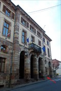
|  Mairie - Badonviller, France Mairie - Badonviller, France
in French Benchmarks Repère géodésique placé sur la façade de la mairie de Badonviller, en Meurthe et Moselle. posted by: Chris777 location: Grand-Est, France date approved: 10/28/2008 last visited: never |
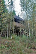 view gallery view gallerySE3.1 km |  Observatoire du lac du Vieux pré - Pierre Percée, France Observatoire du lac du Vieux pré - Pierre Percée, France
in Birdwatching Locations [FR] Lieu d'observation des oiseaux dans une zone protégée du lac du Vieux Pré.
[ENG] Birdwatching location in a protected area of Vieux Pré lake. posted by: Chris777 location: Grand-Est, France date approved: 10/28/2008 last visited: 04/14/2007 |
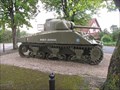 view gallery view galleryNE3.1 km |  M4 Sherman Medium Tank named 'Mort-Homme', Badonviller, France. M4 Sherman Medium Tank named 'Mort-Homme', Badonviller, France.
in Military Ground Equipment Displays A tank placed to commemorate the liberation of Badonviller from the Germans by the French General Leclerc in 1944, during World War II. posted by: Ourspolaire&Gemeloj location: Grand-Est, France date approved: 06/12/2012 last visited: 06/25/2013 |
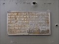 view gallery view galleryNE3.1 km |  Badonviller : Mémorial char de la libération, Mort-Homme de la 2e DB du général Leclerc Badonviller : Mémorial char de la libération, Mort-Homme de la 2e DB du général Leclerc
in World War II Memorials / Monuments During the WW II, 1944, the liberation of Badonviller of the German by the French General Leclerc! posted by: Ourspolaire&Gemeloj location: Grand-Est, France date approved: 06/09/2012 last visited: 06/25/2013 |
 view gallery view gallery SW4.7 km SW4.7 km
| BERTRICHAMPS II in French Benchmarks La deuxième borne de la commune de Bertrichamps (54) posted by: Pat5488 location: Grand-Est, France date approved: 09/22/2008 last visited: 03/22/2015 |
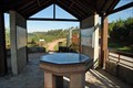 view gallery view gallerySE5.1 km |  Belvédère du Lac du Vieux Pré - Pierre Percée, France Belvédère du Lac du Vieux Pré - Pierre Percée, France
in Orientation Tables [FR] Table d'orientation près du barrage du lac du Vieux Pré, aussi appelé lac de Pierre Percée.
[ENG] Orientation table nearby the Vieux Pré lake, also known as Pierre Percée lake. posted by: Chris777 location: Grand-Est, France date approved: 10/29/2008 last visited: 09/26/2010 |
 view gallery view gallery E5.1 km E5.1 km
| Eglise - Pierre Percée, France in French Benchmarks Repère géodésique placé sur l'église du village de Pierre Percée. posted by: Chris777 location: Grand-Est, France date approved: 10/28/2008 last visited: 04/14/2007 |
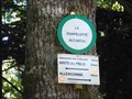
 view gallery view galleryE6.6 km |  Col de la Chapelotte- Grand-Est-France Col de la Chapelotte- Grand-Est-France
in Named Mountain Gaps Un petit col dans le Massif des Vosges. A little gap in Vosges Mountains posted by: gemeloj location: Grand-Est, France date approved: 08/24/2018 last visited: 10/30/2018 |
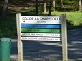
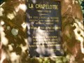
 view gallery view galleryE6.6 km |  La Chapelotte alt: 447m-Lorraine,France La Chapelotte alt: 447m-Lorraine,France
in Elevation Signs Un col dans les Vosges! A summit in Vosges! posted by: gemeloj location: Grand-Est, France date approved: 11/24/2014 last visited: never |
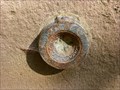
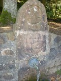 view gallery view galleryE6.6 km |  Une belle fontaine gravée- Col de la Chapelotte-Lorraine,France Une belle fontaine gravée- Col de la Chapelotte-Lorraine,France
in Fountains A fountain in a historic site! Une fontaine dans un endroit historique! posted by: gemeloj location: Grand-Est, France date approved: 11/20/2014 last visited: never |
 view gallery view galleryE6.6 km |  Site de combats de 14/18-Col de la Chapelotte-Lorraine,France Site de combats de 14/18-Col de la Chapelotte-Lorraine,France
in World War I Memorials and Monuments Souvenirs de violents combats! Memories of fierce fighting posted by: gemeloj location: Grand-Est, France date approved: 11/27/2014 last visited: never |
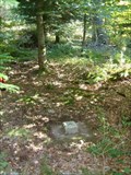
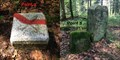
 view gallery view galleryE6.8 km | Un repère dans la fôret-col de la Chapelotte-Lorraine,France in French Benchmarks Un repère sur une chapelle historique! posted by: gemeloj location: Grand-Est, France date approved: 11/24/2014 last visited: never |
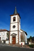
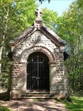 view gallery view galleryE6.8 km |  Chapelle de la Chapelotte-Lorraine,France Chapelle de la Chapelotte-Lorraine,France
in Waychapels Une chapelle dans la fôret! A chapel in the forest! posted by: gemeloj location: Grand-Est, France date approved: 11/23/2014 last visited: never |
 view gallery view gallery S7.6 km S7.6 km
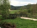
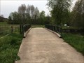
|  Le Pont Bailey de Raon l'étape - France Le Pont Bailey de Raon l'étape - France
in Bailey Bridges Posé sur la voie verte à La Trouche, le pont Bailey a été inauguré à l'occasion du 70e anniversaire de la libération de la ville.
Located on the greenway at La Trouche, the Bailey Bridge was inaugurated for the 70th anniversary of the town. posted by: Alfouine location: Grand-Est, France date approved: 06/01/2019 last visited: 10/09/2022 |
 view gallery view galleryS7.6 km | ") Le Pont Bailey de Raon l'étape - France Le Pont Bailey de Raon l'étape - France
in Histoires de France (French historical markers) Posé sur la voie verte à La Trouche, le pont Bailey a été inauguré à l'occasion du 70e anniversaire de la libération de la ville.
Located on the greenway at La Trouche, the Bailey Bridge was inaugurated for the 70th anniversary of the town. posted by: Alfouine location: Grand-Est, France date approved: 05/04/2019 last visited: never |
 view gallery view galleryS7.6 km |  Le Pont Bailey de Raon l'étape - France Le Pont Bailey de Raon l'étape - France
in Relocated Structures Posé sur la voie verte à La Trouche, le pont Bailey a été inauguré à l'occasion du 70e anniversaire de la libération de la ville.
Located on the greenway at La Trouche, the Bailey Bridge was inaugurated for the 70th anniversary of the town. posted by: Alfouine location: Grand-Est, France date approved: 05/04/2019 last visited: never |
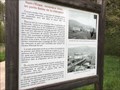
 view gallery view galleryS7.6 km |  Pierre-Percée : le pont de la libération et son histoire - France Pierre-Percée : le pont de la libération et son histoire - France
in News Article Locations Posé sur la voie verte à La Trouche, le pont Bailey a été inauguré à l'occasion du 70e anniversaire de la libération de la ville.
Located on the greenway at La Trouche, the Bailey Bridge was inaugurated for the 70th anniversary of the town. posted by: Alfouine location: Grand-Est, France date approved: 05/03/2019 last visited: never |
 view gallery view galleryS7.6 km |  La route de la Trouche - France La route de la Trouche - France
in Plank Roads Sur la route menant à la Trouche, un pont en planche de bois.
On the road leading to La Trouche, a bridge made of wood. posted by: Alfouine location: Grand-Est, France date approved: 05/03/2019 last visited: never |
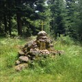 view gallery view gallerySE8 km |  Vierge du Haut Port, Raon L’Etape, Vosges, France Vierge du Haut Port, Raon L’Etape, Vosges, France
in Cairns [FR] Sur la crête du massif forestier, à 605m, oratoire acceuillant une statue de la Vierge Marie
[EN] On the crest of the forest , at 605m , oratory welcoming a statue of the Virgin Mary posted by: CrAzYoTa location: Grand-Est, France date approved: 06/28/2016 last visited: never |
 view gallery view gallerySE8 km | RAON-L'ETAPE VI / 8837206 in French Benchmarks Site du Réseau de détail, Raon L'Etape, Vosges, France posted by: CrAzYoTa location: Grand-Est, France date approved: 07/01/2016 last visited: never |
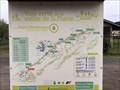 view gallery view galleryS8.4 km |  Voie Verte de la vallée de la Plaine - Raon l'étape - France Voie Verte de la vallée de la Plaine - Raon l'étape - France
in Cycling Routes La Voie verte de la Vallée de la Plaine est une piste cyclable qui reprend l'emprise de l'ancienne voie ferrée.
The Green Lane of the Plains Valley is a bicycle path that follows the old railway line. posted by: Alfouine location: Grand-Est, France date approved: 05/08/2019 last visited: never |
 view gallery view galleryS8.4 km |  Voie Verte de la vallée de la Plaine - Raon l'étape - France Voie Verte de la vallée de la Plaine - Raon l'étape - France
in Rails to Trails La Voie verte de la Vallée de la Plaine est une piste cyclable qui reprend l'emprise de l'ancienne voie ferrée.
The Green Lane of the Plains Valley is a bicycle path that follows the old railway line. posted by: Alfouine location: Grand-Est, France date approved: 05/16/2019 last visited: never |
 view gallery view galleryS8.4 km |  Voie Verte de la vallée de la Plaine - Raon l'étape - France Voie Verte de la vallée de la Plaine - Raon l'étape - France
in Official Local Tourism Attractions La Voie verte de la Vallée de la Plaine est une piste cyclable qui reprend l'emprise de l'ancienne voie ferrée.
The Green Lane of the Plains Valley is a bicycle path that follows the old railway line. posted by: Alfouine location: Grand-Est, France date approved: 05/11/2019 last visited: never |
|