 view gallery view gallery SW3.2 km SW3.2 km
|   La SNSM du Conquet. La SNSM du Conquet.
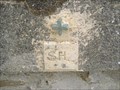
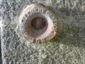
in French Benchmarks Repère de nivellement original pour hommage aux sauveteurs de la mer. posted by:  bob29 bob29 location: France date approved: 09/04/2008 last visited: never |
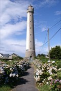
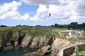
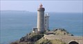
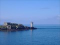 view gallery view gallerySW3.2 km |  Le phare de Kermorvan Le phare de Kermorvan
in Coastal Lighthouses Le phare participe au balisage des chenaux de la Helle et du Four.
The headlight takes part in the beaconing of the channels "de la helle" and the "Four". posted by: bob29 location: France date approved: 07/09/2007 last visited: 12/11/2022 |
 view gallery view gallery NW4 km NW4 km
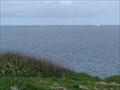
|  Pointe de Corsen - Plouarzel, France Pointe de Corsen - Plouarzel, France
in Wikipedia Entries FR - La pointe de Corsen est un cap situé sur la commune de Plouarzel, dans le Finistère.
EN - Pointe de Corsen is a cape located in the town of Plouarzel, in Finistère. posted by:  geotrouvtou59 geotrouvtou59 location: Bretagne, France date approved: 05/09/2023 last visited: 05/10/2023 |
 view gallery view galleryNW4 km |  Pointe de Corsen - Plouarzel, France Pointe de Corsen - Plouarzel, France
in Scenic Overlooks FR - La pointe de Corsen est un cap situé sur la commune de Plouarzel, dans le Finistère.
EN - Pointe de Corsen is a cape located in the town of Plouarzel, in Finistère. posted by: geotrouvtou59 location: Bretagne, France date approved: 05/09/2023 last visited: 05/10/2023 |
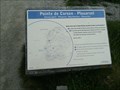
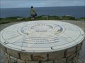 view gallery view galleryNW4 km |  Table d'Orientation - La Point de Corsen - Plouarzel, France Table d'Orientation - La Point de Corsen - Plouarzel, France
in Orientation Tables FR - C'est une table d'orientation toute récente, réalisée par le Communauté de communes.
EN - This is a very recent orientation table, produced by the Community of Communes. posted by: geotrouvtou59 location: Bretagne, France date approved: 05/12/2023 last visited: 05/13/2023 |
 view gallery view gallery N4.5 km N4.5 km
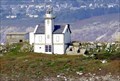
| Phare de Trézien - Plouarzel, Finistère, FRA in Coastal Lighthouses The Trézien lighthouse is located inland 500 meters from the shore and 1.5 kilometers from the tip of Corsen, in the town of Plouarzel in Finistère. posted by: André de Montbard location: Bretagne, France date approved: 11/18/2020 last visited: never |
 view gallery view gallery SE6 km SE6 km
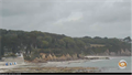
|  Webcam Vue sur la plage - Plougonvelin, France Webcam Vue sur la plage - Plougonvelin, France
in Web Cameras [EN] Webcam broadcasting live images, located on the roof of the tourist office of Plougonvelin.
[FR] Webcam diffusant des images en direct, située sur le toit de l'office de tourisme de Plougonvelin. posted by: pmaupin location: Bretagne, France date approved: 06/07/2017 last visited: never |
 view gallery view gallery S6.1 km S6.1 km
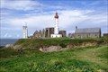
| Phare de Saint-Mathieu - Plougonvelin, Finistère, FRA in Coastal Lighthouses The Saint-Mathieu Lighthouse is a lighthouse located on Pointe Saint-Mathieu in Plougonvelin, around Brest in Finistère. The lighthouse is open to the public. posted by: André de Montbard location: Bretagne, France date approved: 11/18/2020 last visited: 12/11/2022 |
 view gallery view gallerySE7.1 km |  Fort de Bertheaume - Plougonvelin, Finistère, FRA Fort de Bertheaume - Plougonvelin, Finistère, FRA
in Zip-line Two ziplines crossing the narrow gorge between the coast and the islandfortress of Fort de Bertheaume. posted by: André de Montbard location: Bretagne, France date approved: 11/29/2020 last visited: never |
 view gallery view gallery NE7.7 km NE7.7 km
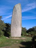
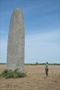
|  Le menhir de Kerloas Le menhir de Kerloas
in Megalithic Monuments Menhir de Kerloas, le plus haut en Bretagne / the greatest in Bretagne posted by: bob29 location: France date approved: 06/19/2007 last visited: 12/14/2014 |
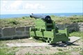 view gallery view galleryN9.7 km |  12pounder gun - Batterie de l'Aber Ildut, Finistère, FRA 12pounder gun - Batterie de l'Aber Ildut, Finistère, FRA
in Static Artillery Displays Coastal battery against english treat was installed 1740 to defend the port of L'Aber Ildut. posted by: André de Montbard location: Bretagne, France date approved: 11/22/2020 last visited: never |
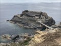
 view gallery view galleryN11.3 km | Monuments mégalithiques de l'île Melon - Porspoder, Finistère, FRA in Megalithic Monuments There are many megalithic monuments on the small Île Melon in the municipality of Porspoder, Brittany. posted by: André de Montbard location: Bretagne, France date approved: 11/23/2020 last visited: never |
 view gallery view gallerySE12.1 km | La pointe du minou. in French Benchmarks D'une altitude très précise de 25,408 m ce repère en bronze se frotte tous les jours à l'air iodé de la mer d'iroise.
posted by: bob29 location: France date approved: 08/21/2008 last visited: never |
 view gallery view gallerySE12.1 km | Le phare du petit minou in Coastal Lighthouses This cylindrical tower, built in 1848 on the northern coast of the narrow part of Brest, forms an alignment with the headlight of Portzic. Its height with the top of the ground is of 26 meters and with the top of the open seas of 34 meters. posted by: bob29 location: France date approved: 05/16/2007 last visited: 12/06/2022 |
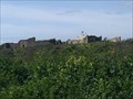
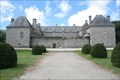 view gallery view galleryNE12.2 km |  Domaine de Kergroadès - Brélès, France Domaine de Kergroadès - Brélès, France
in Monuments Historiques Français Le château de Kergroadès (Kergroadez en breton) est un château du XVIIe siècle situé sur la commune de Brélès.
-
Kergroadès Castle (Kergroadez in Breton) is a 17th century castle located in the town of Brélès. posted by: André de Montbard location: Bretagne, France date approved: 11/18/2020 last visited: 12/14/2022 |
 view gallery view galleryNE12.2 km |  Château de Kergroadès - Brélès, Finistère, FRA Château de Kergroadès - Brélès, Finistère, FRA
in Castles Kergroadès Castle (Kergroadez in Breton) is a 17th century castle located in the town of Brélès, in the Finistère department, in Brittany.
It has been classified as a historical monument since May 1995. posted by: André de Montbard location: Bretagne, France date approved: 11/18/2020 last visited: 12/14/2022 |
 view gallery view galleryN12.4 km | Menhir de Kergadiou - Plourin, Finistère, FRA in Megalithic Monuments The menhir of Kergadiou is a megalithic monument of France located in Finistère. With 8.75 meters in height, it is the second tallest menhir in Brittany after that of Kerloas. It has been classified as a historical monument since September 25, 1883. posted by: André de Montbard location: Bretagne, France date approved: 11/22/2020 last visited: never |
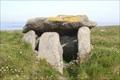
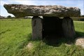 view gallery view galleryN12.6 km | Dolmen et menhir de Kerivoret - Porspoder, Finistère, FRA in Megalithic Monuments The Kerivoret dolmen, which has been under protection since 1923, and the menhir about 3.5 m high, 1.6 m wide and 0.9 m thick about 50 m away are in Porspoder, near Ploudalmézeau in the Finistère department in Brittany in France. posted by: André de Montbard location: Bretagne, France date approved: 11/22/2020 last visited: never |
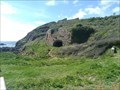
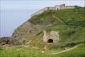
 view gallery view gallerySE15.1 km | L'îlot des Capucins - Roscanvel, France in Monuments Historiques Français L'îlot des Capucins, avancée rocheuse de la pointe des Capucins, est un îlot rocheux situé dans l'océan Atlantique au pied de la falaise de la commune de Roscanvel, dans la Presqu'île de Crozon en France. posted by: André de Montbard location: Bretagne, France date approved: 10/31/2020 last visited: 01/22/2023 |
 view gallery view gallerySE15.1 km |  Fort de Capucins - Roscanvel, Camaret - Finistère, FRA Fort de Capucins - Roscanvel, Camaret - Finistère, FRA
in Historic Forts Îlot des Capucins (Islet of the Capuchins) is a rocky islet at the foot of a cliff in the commune of Roscanvel on the Crozon peninsula. posted by: André de Montbard location: Bretagne, France date approved: 10/30/2020 last visited: 01/22/2023 |
 view gallery view gallerySE15.3 km | Phare du Toulinguet - Camaret-sur-Mer, Finistére, FRA in Coastal Lighthouses The Toulinguet lighthouse is located at the end of the Crozon peninsula in the town of Camaret-sur-Mer in Brittany. posted by: André de Montbard location: Bretagne, France date approved: 12/26/2020 last visited: 01/22/2023 |
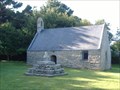 view gallery view galleryN15.9 km |  La chapelle Saint Gonvel à Landunvez FRANCE La chapelle Saint Gonvel à Landunvez FRANCE
in This Old Church La chapelle n'est plus un lieu de culte mais demeure un but de promenade particulièrement apprécié.
The vault is not any more one place of worship but remains a goal of walk particularly appreciated. posted by: bob29 location: France date approved: 08/21/2007 last visited: 08/26/2007 |
 view gallery view gallerySE16.4 km | Fort de la Fraternité - Roscanvel, France in Castles FR - Le fort de la Fraternité se trouve sur la commune de Roscanvel. Il fait partie du système de défense du goulet de Brest.
EN - Fort de la Fraternité is located in the town of Roscanvel. It is part of the defense system of the Brest gully. posted by: geotrouvtou59 location: Bretagne, France date approved: 05/15/2023 last visited: 05/26/2023 |
 view gallery view gallerySE16.4 km | Fort de la Fraternité - Roscanvel, France in Wikipedia Entries FR - Le fort de la Fraternité se trouve sur la commune de Roscanvel. Il fait partie du système de défense du goulet de Brest.
EN - Fort de la Fraternité is located in the town of Roscanvel. It is part of the defense system of the Brest gully. posted by: geotrouvtou59 location: Bretagne, France date approved: 05/09/2023 last visited: 05/10/2023 |
 view gallery view gallerySE16.4 km | Fort de La Fraternité - Roscanvel, Camaret, 29, FRA in Historic Forts The Fort de la Fraternité (fort of brotherhood) is a fort located on the îlot du Diable in Roscanvel, France. posted by: André de Montbard location: Bretagne, France date approved: 10/31/2020 last visited: 01/22/2023 |
|