 view gallery view gallery S13.2 km S13.2 km
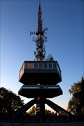
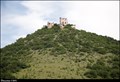
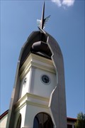
|   Avas Look-out tower - Miskolc - Hungary Avas Look-out tower - Miskolc - Hungary
in Look-Out Towers Avas Look-out tower - Miskolc - Hungary posted by:  Nebel.com Nebel.com location: Borsod-Abaúj-Zemplén, Hungary date approved: 08/21/2012 last visited: never |
 view gallery view gallery SW15.6 km SW15.6 km
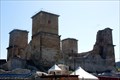
|  Castle of Diósgyor - Hungary Castle of Diósgyor - Hungary
in Castles Castle of Diósgyor - Hungary posted by: Nebel.com location: Borsod-Abaúj-Zemplén, Hungary date approved: 08/21/2012 last visited: 08/27/2013 |
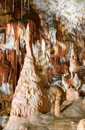
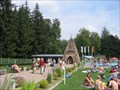 view gallery view galleryS17.9 km |  Thermal cavebath Barlang Miskolc-Tapolca, Hungary Thermal cavebath Barlang Miskolc-Tapolca, Hungary
in Hot Springs Cave bath (thermal bath in a natural cave). posted by: Arne1 location: Borsod-Abaúj-Zemplén, Hungary date approved: 05/18/2010 last visited: 04/18/2013 |
 view gallery view galleryS17.9 km |  Thermal cavebath Barlang Miskolc-Tapolca, Hungary Thermal cavebath Barlang Miskolc-Tapolca, Hungary
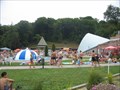
in Spas, Hammams, Mineral Baths and Saunas In the regional centre of north-eastern Hungary, well-known for its therapeutic effects since the 16th century, spring water with a temperature of 30 °C in cave passages unique in Europe. posted by: Arne1 location: Borsod-Abaúj-Zemplén, Hungary date approved: 05/18/2010 last visited: 04/18/2013 |
 view gallery view galleryS17.9 km |  Barlangfürdoro Miskolc-Tapolca, Hungary Barlangfürdoro Miskolc-Tapolca, Hungary
in Public Swimming Pools The Cave Bath is a thermal bath in a natural cave in Miskolctapolca, which is part of the city of Miskolc, Hungary, and is unique in Europe posted by: Arne1 location: Borsod-Abaúj-Zemplén, Hungary date approved: 05/19/2010 last visited: 04/18/2013 |
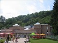
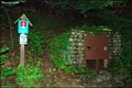
 view gallery view gallerySW19.5 km |  Old Iron Smelter - Újmassa - Hungary Old Iron Smelter - Újmassa - Hungary
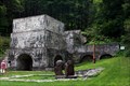
in Iron Furnace Ruins Old Iron Smelter - Újmassa - Hungary posted by: Nebel.com location: Borsod-Abaúj-Zemplén, Hungary date approved: 08/29/2012 last visited: 05/07/2017 |
 view gallery view galleryS27.8 km |  Battle of Muhi, Hungary Battle of Muhi, Hungary
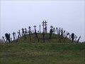
in Battlefields This is a specific monumnt of the Battle of Mufi which was in 1241. The coordinates show you the parking plce, which is the entrence for this little park. posted by: taska location: Borsod-Abaúj-Zemplén, Hungary date approved: 12/13/2010 last visited: 12/14/2010 |
 view gallery view gallerySW32.8 km |  Fátyol-waterfall, Szalajka-valley Fátyol-waterfall, Szalajka-valley
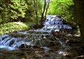
in Waterfalls Fátyol-waterfall is one of the most frequented sights of North-Hungary. posted by:  kyruska kyruska location: Heves, Hungary date approved: 01/30/2006 last visited: 07/26/2011 |
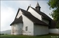 view gallery view gallery N33.5 km N33.5 km
|  Church of St. Andrew / Szent András templom (Tornaszentandrás, Hungary) Church of St. Andrew / Szent András templom (Tornaszentandrás, Hungary)
in Medieval Churches In village Tornaszentandrás, in picturesque landscape of northeast Hungary close to the Slovakian borders, you can find small but unique Romanesque church of St. Andrew from the Árpád dynasty age... posted by: Dorcadion Team location: Borsod-Abaúj-Zemplén, Hungary date approved: 06/06/2009 last visited: 03/13/2011 |
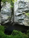
 view gallery view gallery NW36.4 km NW36.4 km
|  Aggtelek Karst (Hungary and Slovakia) Aggtelek Karst (Hungary and Slovakia)
in World Heritage Sites Two countries (Hungary and Slovakia) share the caves of the Aggelek Karst posted by: Gavriel location: Borsod-Abaúj-Zemplén, Hungary date approved: 11/06/2005 last visited: 08/26/2017 |
 view gallery view galleryNW43 km |  Silická ladnica - Slovakia Silická ladnica - Slovakia
in Natural Sinkholes Corrosive-collapse sinkhole in the Slovak Karst. posted by: Noe1 location: Košický kraj, Slovakia date approved: 06/02/2013 last visited: 08/07/2019 |
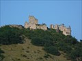 view gallery view galleryN44.3 km |  Turniansky hrad - Slovensko Turniansky hrad - Slovensko
in Satellite Imagery Oddities Turna Castle is a castle in Turna nad Bodvou. posted by: Noe1 location: Košický kraj, Slovakia date approved: 01/18/2017 last visited: never |
 view gallery view galleryN44.3 km | Turnianský hrad / Turna Castle (East Slovakia) in Castles Ruins of medieval Turna Castle (Turnianský hrad), built in the 14th century, rises on limestone karst-hill above East-Slovakian village Turna nad Bodvou only 5 km of Hungarian borders... posted by: Dorcadion Team location: Košický kraj, Slovakia date approved: 05/19/2014 last visited: 04/24/2010 |
 view gallery view galleryNW45.7 km | ") Gombasecká jaskyna Gombasecká jaskyna
in Cave Entrances (Natural) Cave in Slovakia - 1 525 m available for public. posted by: thailon location: Košický kraj, Slovakia date approved: 05/18/2007 last visited: 08/07/2019 |
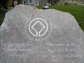
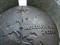 view gallery view galleryN46.5 km |  Globe on Monument of 21st meridian, Moldava nad Bodvou, Slovakia Globe on Monument of 21st meridian, Moldava nad Bodvou, Slovakia
in Earth Globes Kovový globus je soucástí žulového pomníku, pripomínajícího existenci 21. poledníku ve meste Moldava / Metal Globe is part of a granite monument commemorating existence of 21st meridian in Moldava. posted by: Noe1 location: Košický kraj, Slovakia date approved: 09/20/2012 last visited: 05/18/2014 |
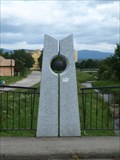 view gallery view galleryN46.5 km |  21. poledník / 21st Meridian, Moldava nad Bodvou, Slovakia 21. poledník / 21st Meridian, Moldava nad Bodvou, Slovakia
in Great Lines of Earth Pomník, oznacující prubeh 21. poledníku v Moldave / Monument, marking the 21st meridian in Moldava. posted by: Noe1 location: Košický kraj, Slovakia date approved: 09/20/2012 last visited: 05/18/2014 |
 view gallery view gallerySW46.8 km |  Turkish Minaret in Eger - Hungary Turkish Minaret in Eger - Hungary
in Preserved Architectural Remnants and Ruins Turkish Minaret in Eger - Hungary posted by: Nebel.com location: Heves, Hungary date approved: 07/20/2011 last visited: 06/26/2013 |
 view gallery view gallerySW47 km |  Undercover townclock, Eger - Hungary Undercover townclock, Eger - Hungary
in Town Clocks Undercover townclock, Eger - Hungary posted by: Nebel.com location: Heves, Hungary date approved: 07/18/2011 last visited: 06/26/2013 |
 view gallery view gallerySW47 km |  Zalár pharmacy - Eger, Hungary Zalár pharmacy - Eger, Hungary
in Independent Pharmacies Zalár pharmacy - Eger, Hungary posted by: Nebel.com location: Heves, Hungary date approved: 07/18/2011 last visited: never |
 view gallery view gallerySW47 km |  Eger - Heves, Hungary Eger - Heves, Hungary
in City Names in Giant Letters EGER - city name in ono of the market places posted by: djdomin location: Heves, Hungary date approved: 03/25/2024 last visited: never |
 view gallery view gallerySW47 km |  Rotary cabinet Eger, Hotel Flora Rotary cabinet Eger, Hotel Flora
in Rotary International Markers Rotary cabinet Eger, Hotel Flora posted by: Nebel.com location: Heves, Hungary date approved: 05/09/2011 last visited: never |
 view gallery view galleryN47.3 km | Krásnohorská jaskyna / The Krásnohorská Cave (Krásnohorská Dlhá Lúka - East Slovakia) in Cave Entrances (Natural) The Krásnohorská Cave (Krásnohorská jaskyna), a part of "Caves of Aggtelek Karst and Slovak Karst" UNESCO World heritage site, is one of real jewels of Slovakian nature and also great target for tourists loving adventure-type of nature exploration.. posted by: Dorcadion Team location: Košický kraj, Slovakia date approved: 03/12/2010 last visited: 02/23/2013 |
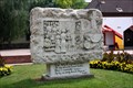 view gallery view galleryS48.3 km |  Relief Art Sculpture, Mezokövesd, Hungary Relief Art Sculpture, Mezokövesd, Hungary
in Relief Art Sculptures Relief Art Sculpture, Mezokövesd, Hungary posted by: Nebel.com location: Borsod-Abaúj-Zemplén, Hungary date approved: 07/18/2011 last visited: never |
 view gallery view galleryS48.3 km |  1956 monument, Mezokövesd - Hungary 1956 monument, Mezokövesd - Hungary
in Monuments of the Eastern Freedomfights 1956 monument, Mezokövesd - Hungary posted by: Nebel.com location: Borsod-Abaúj-Zemplén, Hungary date approved: 07/18/2011 last visited: never |
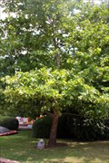 view gallery view galleryS48.3 km |  Freedom tree Mezokövesd - Hungary Freedom tree Mezokövesd - Hungary
in Dedicated Trees Freedom tree Mezokövesd - Hungary posted by: Nebel.com location: Borsod-Abaúj-Zemplén, Hungary date approved: 07/21/2011 last visited: never |
|