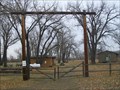
 view gallery view gallery W12.1 km W12.1 km
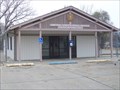
|   Frazer, Montana 59225 Frazer, Montana 59225
in U.S. Post Offices Small town post office. posted by:  NGComets NGComets location: Montana date approved: 11/01/2012 last visited: 06/09/2023 |
 view gallery view gallery E25.7 km E25.7 km
|  The Lewis and Clark Bridge - Wolf Point (Montana) USA The Lewis and Clark Bridge - Wolf Point (Montana) USA
in Truss Bridges a truss bridge located on state highway 13 in the town of Wolf Point (Montana)USA posted by: oiseau_ca location: Montana date approved: 09/03/2014 last visited: 04/24/2023 |
 view gallery view galleryE25.7 km |  The Lewis and Clark Bridge - Wolf Point (Montana) USA The Lewis and Clark Bridge - Wolf Point (Montana) USA
in Orphaned Bridges an abandoned truss bridge located on state highway 13 in the town of Wolf Point (Montana)USA posted by: oiseau_ca location: Montana date approved: 09/04/2014 last visited: 04/24/2023 |
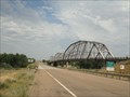 view gallery view galleryE25.7 km |  LONGEST truss bridge in Montana - Wolf Point (Montana) USA LONGEST truss bridge in Montana - Wolf Point (Montana) USA
in Superlatives an abandoned truss bridge located on state highway 13 in the town of Wolf Point (Montana) USA posted by: oiseau_ca location: Montana date approved: 09/04/2014 last visited: 04/24/2023 |
 view gallery view galleryE25.7 km |  The Lewis and Clark Bridge - Wolf Point, Montana The Lewis and Clark Bridge - Wolf Point, Montana
in U.S. National Register of Historic Places an abandoned truss bridge located on state highway 13 near the town of Wolf Point, Montana, USA posted by: oiseau_ca location: Montana date approved: 11/26/2014 last visited: 04/24/2023 |
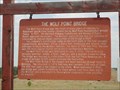 view gallery view galleryE25.7 km |  The Lewis and Clark Bridge - Wolf Point (Montana) USA The Lewis and Clark Bridge - Wolf Point (Montana) USA
in Montana Historical Markers a historical sign placed near an abandoned truss bridge located on state highway 13 in the town of Wolf Point (Montana) USA posted by: oiseau_ca location: Montana date approved: 09/03/2014 last visited: 04/24/2023 |
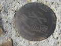 view gallery view galleryW32.8 km |  Corps of Discovery II – Milk River, Fort Peck, MT Corps of Discovery II – Milk River, Fort Peck, MT
in U.S. Benchmarks Corps of Discovery II – Milk River, Fort Peck, MT, is a 4-inch Lewis and Clark commemorative disk located at the Milk River Observation Point above the confluence of the Missouri and Milk Rivers near the Fort Peck Dam in MT. posted by:  seventhings seventhings location: Montana date approved: 09/09/2006 last visited: 05/12/2007 |
 view gallery view galleryW35.2 km | ODB 15 - Fort Peck, Montana in U.S. Benchmarks Located on the Fort Peck Spillway posted by: Bon Echo location: Montana date approved: 07/26/2018 last visited: never |
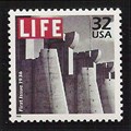 view gallery view galleryW35.4 km |  Spillway Gates, Fort Peck Dam Spillway Gates, Fort Peck Dam
in Philatelic Photographs A section of the spillway for the Fort Peck Dam in eastern Montana graced the cover of the first issue of LIFE magazine. The photograph was taken during construction of the dam in 1936. posted by: hykesj location: Montana date approved: 09/20/2013 last visited: never |
 view gallery view galleryW36.5 km | Nashua, Montana 59248 in U.S. Post Offices Post office in a very small town. posted by: NGComets location: Montana date approved: 11/02/2012 last visited: 07/14/2018 |
 view gallery view galleryW37.5 km |  Nashua Cemetery, Nashua, Montana Nashua Cemetery, Nashua, Montana
in Worldwide Cemeteries Small cemetery along Highway 2 in Montana with about 150 graves. posted by: NGComets location: Montana date approved: 01/09/2013 last visited: never |
 view gallery view gallery SE38.3 km SE38.3 km
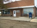
| Vida, Montana 59274 in U.S. Post Offices Post office in a very small town. posted by: NGComets location: Montana date approved: 11/01/2012 last visited: 06/09/2023 |
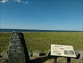 view gallery view galleryW38.9 km |  Fort Peck Dam Landslide Memorial - Fort Peck, Montana Fort Peck Dam Landslide Memorial - Fort Peck, Montana
in Disaster Memorials Signs and memorial stones to remember the events and those who perished in the Fort Peck Dam "Slide of '38" posted by: Bon Echo location: Montana date approved: 10/03/2018 last visited: never |
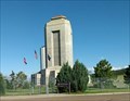 view gallery view galleryW38.9 km |  Fort Peck Project- Fort Peck, Montana Fort Peck Project- Fort Peck, Montana
in WPA Projects According to the sign, the Fort Peck Project was "the single largest employer of the New Deal" posted by: Bon Echo location: Montana date approved: 09/22/2018 last visited: never |
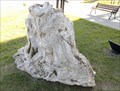 view gallery view galleryW40.6 km |  Petrified Trees - Fort Peck, MT Petrified Trees - Fort Peck, MT
in Paleontology and Fossils Two sections of Petrified Trees at the Fort Peck Interpretive Center posted by: Bon Echo location: Montana date approved: 07/29/2018 last visited: never |
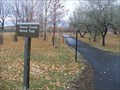 view gallery view galleryW41 km |  Beaver Creek Nature Trail, Ft. Peck, Montana Beaver Creek Nature Trail, Ft. Peck, Montana
in Hiking and walking trailheads Approximately 3 miles of paved nature trails winding through and around the local campground. posted by: NGComets location: Montana date approved: 01/07/2013 last visited: never |
 view gallery view galleryW41.2 km |  Boy Scout Park, Ft. Peck, Montana Boy Scout Park, Ft. Peck, Montana
in Boy Scout Camps A rustic camp on Lake Peck, Montana. posted by: NGComets location: Montana date approved: 02/17/2013 last visited: never |
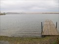 view gallery view galleryW42 km |  Roundhouse Point Boat Dock, Ft. Peck, Montana Roundhouse Point Boat Dock, Ft. Peck, Montana
in Boat Ramps One of several boat docks on Montana's largest body of water, Lake Peck. posted by: NGComets location: Montana date approved: 11/06/2012 last visited: never |
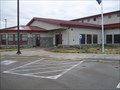 view gallery view galleryW42.3 km |  Ft. Peck State Fish Hatchery, Ft. Peck, Montana Ft. Peck State Fish Hatchery, Ft. Peck, Montana
in Fish Hatcheries Passed in 1999, House Bill 20 authorized a Warm Water Sport Fish Surcharge and a multi-species hatchery for the State of Montana to be located at Fort Peck. The visitors center is open 7am-4pm Monday through Friday and 8am-5pm Saturday and Sunday. posted by: NGComets location: Montana date approved: 11/01/2012 last visited: never |
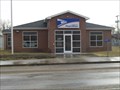
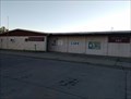 view gallery view galleryW42.6 km | Fort Peck, Montana - 59223 in U.S. Post Offices Small USPS office in Fort Peck MT posted by: Bon Echo location: Montana date approved: 08/02/2018 last visited: 06/09/2023 |
 view gallery view galleryW45.1 km | Old Fort Peck - Fort Peck, MT in Montana Historical Markers Describes the original Fort Peck, which now sits beneath the waters of the Fort Peck Reservoir posted by: Bon Echo location: Montana date approved: 07/23/2018 last visited: never |
 view gallery view galleryE51.2 km |  Fort Peck Reservation, Assiniboine & Sioux - Montana, USA Fort Peck Reservation, Assiniboine & Sioux - Montana, USA
in Nations Within Nations Assiniboine & Sioux - Nakoda posted by: CerealBoxMonsters location: Montana date approved: 07/30/2009 last visited: 02/12/2013 |
 view gallery view galleryE51.5 km | Fort Peck Indian Reservation - Poplar, MT in Montana Historical Markers A small sampling of history of the Assiniboines and Dakota tribes, and of Fort Peck Indian Reservation posted by: Bon Echo location: Montana date approved: 07/23/2018 last visited: never |
 view gallery view gallery NE52.3 km NE52.3 km
|  McDonalds South Web Camera - Scobey, MT McDonalds South Web Camera - Scobey, MT
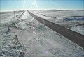
in Web Cameras This is one of 73 (as of January 2017) Road Weather Information System camera sites operated by the Montana Department of Transportation to aid motorists as they make their way across BIG SKY Country. posted by: T0SHEA location: Montana date approved: 02/02/2017 last visited: never |
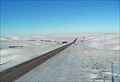 view gallery view galleryNE52.3 km | McDonalds North Web Camera - Scobey, MT in Web Cameras This is one of 73 (as of January 2017) Road Weather Information System camera sites operated by the Montana Department of Transportation to aid motorists as they make their way across BIG SKY Country. posted by: T0SHEA location: Montana date approved: 02/02/2017 last visited: never |
|