 view gallery view gallery S1.4 km S1.4 km
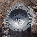
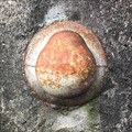
|   A.I.L3 - 127 BIS / 202,782 m A.I.L3 - 127 BIS / 202,782 m
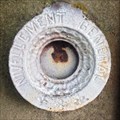
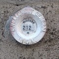
in French Benchmarks Repère cylindrique du nivellement général IGN type M, Cimetière d’Oberhergheim, Haut-Rhin, Alsace, France posted by:  CrAzYoTa CrAzYoTa location: Grand-Est, France date approved: 08/03/2016 last visited: never |
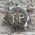
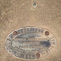 view gallery view galleryS1.4 km | A.I.L3 - 127-I / 202,589 m in French Benchmarks Repère rivet du nivellement général IGN type R , Cimetière d’Oberhergheim, Haut-Rhin, Alsace, France posted by: CrAzYoTa location: Grand-Est, France date approved: 08/03/2016 last visited: never |
 view gallery view gallery NW1.8 km NW1.8 km
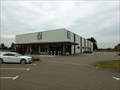
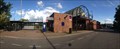
|  ALDI Rue des Alpes, 68127 Niederhergheim - Alsace / France ALDI Rue des Alpes, 68127 Niederhergheim - Alsace / France
in ALDI Stores ALDI Marche 68127 Niederhergheim posted by: Iris & Harry location: Grand-Est, France date approved: 10/01/2016 last visited: never |
 view gallery view galleryS2.7 km | OBERHERGHEIM IX / 6824209 in French Benchmarks stèle géodésique d'Oberhergheim, mire topographique située dans le département français du Haut-Rhin, en Alsace, entre Mulhouse et Colmar. posted by: CrAzYoTa location: Grand-Est, France date approved: 10/05/2016 last visited: never |
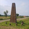
 view gallery view galleryS2.7 km |  Obélisque Terme Nord de la Base d'Oberhergheim - Oberhergheim, Alsace France Obélisque Terme Nord de la Base d'Oberhergheim - Oberhergheim, Alsace France
in Obelisks Stèle géodésique qui est une mire (1804)/ geodesic stele that is the test card (1804) posted by: CrAzYoTa location: Grand-Est, France date approved: 10/05/2016 last visited: never |
 view gallery view gallery E5 km E5 km
| A.I.L3 - 164 / 198,719 m in French Benchmarks Repère Type BOULE du nivellement général IGN, Ancien blockhaus, HETTENSCHLAG, Haut-Rhin/FR posted by: CrAzYoTa location: Grand-Est, France date approved: 05/29/2017 last visited: 05/23/2017 |
 view gallery view galleryNW6.1 km | ") Le "Waschbach" d'Herrlisheim-près-Colmar, France Le "Waschbach" d'Herrlisheim-près-Colmar, France
in Lavoir (wash houses) [FR] La première trace d'un document sur ce lavoir date du 10 novembre 1864 / [EN] The first trace of a document on this washhouse dates from 10/10/1864 / [DE] Die erste Spur eines Dokuments in diesem Waschhaus stammt aus dem 10/10/1864 posted by: CrAzYoTa location: Grand-Est, France date approved: 10/17/2017 last visited: never |
 view gallery view gallery SW6.9 km SW6.9 km
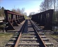
|  Gare de Rouffach, Haut-Rhin, Alsace, France Gare de Rouffach, Haut-Rhin, Alsace, France
in Train Stations/Depots Gare ferroviaire française de la SNCF située sur le territoire de la commune de Rouffach / Train Station in the territory of the town of Rouffach posted by: CrAzYoTa location: Grand-Est, France date approved: 08/10/2016 last visited: never |
 view gallery view gallery N7.6 km N7.6 km
| COLMAR XV - 6806615 in French Benchmarks Site du Réseau de détail, Colmar, Alsace, France posted by: CrAzYoTa location: Grand-Est, France date approved: 10/19/2016 last visited: never |
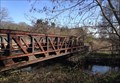 view gallery view galleryN7.6 km |  Truss Bridge over the river the Thur, South of Colmar, Alsace, France Truss Bridge over the river the Thur, South of Colmar, Alsace, France
in Truss Bridges Former Truss bridge which is not anymore used today posted by: CrAzYoTa location: Grand-Est, France date approved: 10/22/2016 last visited: never |
 view gallery view galleryN7.6 km |  Colmar Railroad Bridge - Colmar, Alsace, France Colmar Railroad Bridge - Colmar, Alsace, France
in Railroad Bridges Former railroad bridge which is not anymore used today posted by: CrAzYoTa location: Grand-Est, France date approved: 10/24/2016 last visited: never |
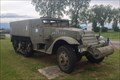 view gallery view gallerySW8 km |  Half-Track M3, RMT Meyenheim, Alsace, France Half-Track M3, RMT Meyenheim, Alsace, France
in Military Ground Equipment Displays [FR] Au premier carrefour, à l'entrée nord de Meyenheim / [EN] At the first crossing at the northern entrance of Meyenheim posted by: CrAzYoTa location: Grand-Est, France date approved: 07/07/2016 last visited: never |
 view gallery view galleryS8.7 km |  "Football" in Meyenheim - Alsace / France "Football" in Meyenheim - Alsace / France
in Realistic Object Sculptures Football Sculpture made of stone posted by: Iris & Harry location: Grand-Est, France date approved: 09/29/2016 last visited: never |
 view gallery view galleryS8.9 km | A.I.L3M3 - 19 / 213,052 m in French Benchmarks Repère cylindrique du nivellement général IGN type M, Hirtzfelden, Haut-Rhin, Alsace, France posted by: CrAzYoTa location: Grand-Est, France date approved: 06/22/2016 last visited: never |
 view gallery view galleryS8.9 km |  Cross near the road, Hirtzfelden - Alsace / France Cross near the road, Hirtzfelden - Alsace / France
in Christian Crosses Old cross near the road D38. posted by: Iris & Harry location: Grand-Est, France date approved: 09/30/2016 last visited: never |
 view gallery view gallery SE8.9 km SE8.9 km
| A.I.L3 - 82 / 211,854m in French Benchmarks Repère cylindrique du nivellement général IGN type M, Hirtzfelden, Haut-Rhin, Alsace, France posted by: CrAzYoTa location: Grand-Est, France date approved: 06/22/2016 last visited: never |
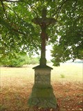
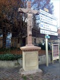 view gallery view galleryNW9 km | Crucifix at crossroads, Eguisheim, Haut-Rhin/FR in Christian Crosses Christian Cross, Established in 1859 and restored in 1946 posted by: CrAzYoTa location: Grand-Est, France date approved: 12/27/2016 last visited: never |
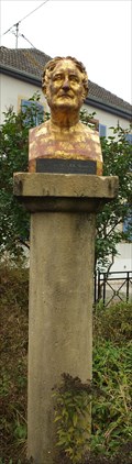 view gallery view gallerySE9 km |  François-Antoine Jecker, Hirtzfelden - Alsace / France François-Antoine Jecker, Hirtzfelden - Alsace / France
in Statues of Historic Figures Bust of François-Antoine Jecker, a French instrument maker. posted by: Iris & Harry location: Grand-Est, France date approved: 10/01/2016 last visited: never |
 view gallery view gallery NE9 km NE9 km
| A.I.K3L3 - 22 / 194,330 m in French Benchmarks Repère type Allemand du nivellement général IGN, Eglise Saint Grégoire, Wolfgantzen, Haut-Rhin, Alsace, France posted by: CrAzYoTa location: Grand-Est, France date approved: 05/29/2017 last visited: 05/12/2017 |
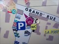 view gallery view galleryNW9 km |  "Vous êtes ici" Eguisheim, Haut-Rhin/FR "Vous êtes ici" Eguisheim, Haut-Rhin/FR
in 'You Are Here' Maps "Vous êtes ici" at the entrance of the main parking of the town, on a map that shows all the hotels, winegrowers and shops and facilities of the city posted by: CrAzYoTa location: Grand-Est, France date approved: 01/12/2017 last visited: never |
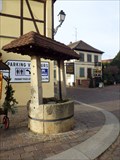 view gallery view galleryNW9 km |  Old draw well, Eguisheim, Haut-Rhin/FR Old draw well, Eguisheim, Haut-Rhin/FR
in Draw Wells Old draw well at the entrance of the main parking of the town posted by: CrAzYoTa location: Grand-Est, France date approved: 12/24/2016 last visited: never |
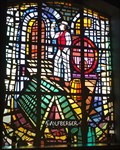 view gallery view galleryNW9.2 km |  Windows at Weingut Wolfberger, Eguisheim - Alsace / France Windows at Weingut Wolfberger, Eguisheim - Alsace / France
in Stained Glass Windows Two stained glass windows at Weingut Wolfberger. posted by: Iris & Harry location: Grand-Est, France date approved: 10/07/2016 last visited: 12/09/2016 |
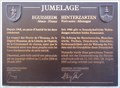 view gallery view galleryNW9.2 km |  Plaque of sister cites Eguisheim & Hinterzarten, Eguisheim/FR Plaque of sister cites Eguisheim & Hinterzarten, Eguisheim/FR
in Sister City Monuments A plaque and a bench dedicated to the Twin cities Eguisheim(Haut-Rhin/Alsace/FR) & Hinterzarten(Schwartzwald/BW/DE) posted by: CrAzYoTa location: Grand-Est, France date approved: 01/15/2017 last visited: 09/24/2016 |
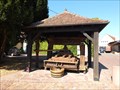 view gallery view galleryNW9.2 km |  Grape Press at Weingut Wolfberger, Eguisheim - Alsace / France Grape Press at Weingut Wolfberger, Eguisheim - Alsace / France
in Old Agricultural Equipment Old wooden grape press, very well restored. posted by: Iris & Harry location: Grand-Est, France date approved: 10/06/2016 last visited: 12/09/2016 |
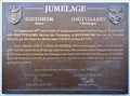 view gallery view galleryNW9.2 km | Plaque of sister cites Eguisheim & Hautvillers, Eguisheim/FR in Sister City Monuments A plaque dedicated to the Twin cities Eguisheim (Haut-Rhin/Alsace/FR) & Hautvillers (Marne/Champagne/FR) posted by: CrAzYoTa location: Grand-Est, France date approved: 01/15/2017 last visited: 09/24/2016 |
|