 view gallery view gallery N16.6 km N16.6 km
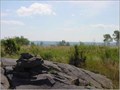
|   Mount Siskiwit -- Isle Royale National Park Mount Siskiwit -- Isle Royale National Park
in Mountain Summits Located on Isle Royale National Park, Mt. Siskiwit can be accessed from the Greenstone Ridge trail. posted by:  srstuart srstuart location: Michigan date approved: 07/07/2006 last visited: 04/24/2015 |
 view gallery view gallery NE20 km NE20 km
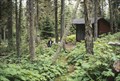
|  Isle Royale Backpacking Shelter - Isle Royale, MI Isle Royale Backpacking Shelter - Isle Royale, MI
in Remote Backcountry Shelters These backcountry shelters are wonderful for campers who want protection from the elements and bugs. posted by:  wildernessmama wildernessmama location: Michigan date approved: 04/24/2015 last visited: never |
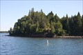
 view gallery view galleryNE20.1 km | ") Cliffs of Chippewa Cliffs of Chippewa
in National Parks (U.S.) Place of Isle Royale history posted by: illuvatar4 location: Michigan date approved: 08/24/2006 last visited: 02/13/2012 |
 view gallery view gallery W23.8 km W23.8 km
|  3 Kinds of Berry Picking -- Windigo Point, Isle Royale NP, MI 3 Kinds of Berry Picking -- Windigo Point, Isle Royale NP, MI
in Berry Picking You can't swing your arms at Windigo Point at Isle Royale NP without hitting a berry patch of some kind: Blackberries, raspberries and thimbleberries abound here. posted by: Benchmark Blasterz location: Michigan date approved: 10/24/2012 last visited: 08/22/2016 |
 view gallery view galleryW28.5 km |  Steamer "SS America" -- Isle Royale Natl Park, MI Steamer "SS America" -- Isle Royale Natl Park, MI
in Shipwrecks The wreck of the SS America is a popular sight off of Isle Royale National Park in Lake Superior. posted by: Benchmark Blasterz location: Michigan date approved: 11/14/2012 last visited: 04/24/2015 |
 view gallery view galleryW28.5 km |  Wreck of SS America -- Isle Royale NP, MI Wreck of SS America -- Isle Royale NP, MI
in Dive Sites The wreck of the SS America is a popular sight and dive location off of Isle Royale National Park in Lake Superior. posted by: Benchmark Blasterz location: Michigan date approved: 11/26/2012 last visited: 04/24/2015 |
 view gallery view galleryNE28.8 km |  Mount Ojibway Fire Tower - Isle Royale, MI Mount Ojibway Fire Tower - Isle Royale, MI
in Look-Out Towers One of the old fire towers built in the 60's by Mattila Construction. posted by: Dew Crew location: Michigan date approved: 09/25/2006 last visited: 08/23/2016 |
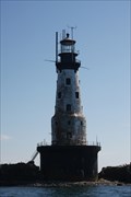 view gallery view galleryW35.7 km |  Rock of Ages Lighthouse Rock of Ages Lighthouse
in Coastal Lighthouses An over century-old landmark historic lighthouse on a tiny rock outcrop in the northern part of Lake Superior. posted by: Benchmark Blasterz location: Michigan date approved: 08/25/2012 last visited: 04/24/2015 |
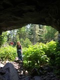 view gallery view galleryNE35.7 km | ") Suzy's Cave - Isle Royal, MI Suzy's Cave - Isle Royal, MI
in Cave Entrances (Natural) Suzy's Cave is a natural cave on Isle Royal in Lake Superior. posted by: m&m O location: Michigan date approved: 04/01/2021 last visited: never |
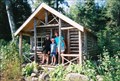
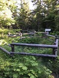
 view gallery view galleryNE37.7 km |  Civilian Conservation Corps Sign and Shelter - Isle Royal, MI Civilian Conservation Corps Sign and Shelter - Isle Royal, MI
in Civilian Conservation Corps At this location visitors will find an information sigh about Isle Royal CCC camps and a shelter. posted by: m&m O location: Michigan date approved: 04/04/2021 last visited: never |
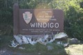
 view gallery view galleryNE37.7 km |  Isle Royale National Park - Isle Royale, Michigan, USA Isle Royale National Park - Isle Royale, Michigan, USA
in National Parks of the World Isle Royale National Park is a remote island wilderness in the middle of Lake Superior. posted by: m&m O location: Michigan date approved: 11/26/2019 last visited: never |
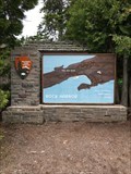
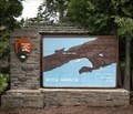
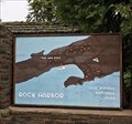
 view gallery view galleryNE37.8 km |  Isle Royale - MI. Isle Royale - MI.
in Literary Sites Posted coordinates are just outside the Rock Harbor Visitor Center on Isle Royal in Lake Superior. posted by: m&m O location: Michigan date approved: 03/31/2021 last visited: never |
 view gallery view galleryNE37.8 km |  Isle Royale National Park - Isle Royale, Michigan, USA Isle Royale National Park - Isle Royale, Michigan, USA
in 1000 Places to See Before You Die Isle Royale is located in Lake Superior. posted by: m&m O location: Michigan date approved: 04/13/2020 last visited: 09/20/2007 |
 view gallery view galleryNE37.8 km |  Wolves on Isle Royale - Houghton Township, MI Wolves on Isle Royale - Houghton Township, MI
in News Article Locations The wolf population of Isle Royale National Park is being reinforced. posted by: m&m O location: Michigan date approved: 10/16/2019 last visited: never |
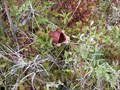 view gallery view galleryNE38 km |  Raspberry Island - Isle Royale National Park, MI Raspberry Island - Isle Royale National Park, MI
in Carnivorous Plant Localities These carnivorous plants are located in Raspberry Island in Lake Superiors. posted by: m&m O location: Michigan date approved: 06/22/2021 last visited: never |
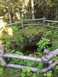
 view gallery view galleryNE38 km | ") Smithwick Mine - Isle Royale, MI Smithwick Mine - Isle Royale, MI
in Cave Entrances (Artificial) This location is the opening to a copper mine on Isle Royal island in Lake Superior. posted by: m&m O location: Michigan date approved: 04/02/2021 last visited: never |
 view gallery view galleryNE38 km |  Smithwick Mine - Rock Harbor, Isle Royale, Michigan, USA Smithwick Mine - Rock Harbor, Isle Royale, Michigan, USA
in Mines Opening of a 1840's copper mine. posted by: m&m O location: Michigan date approved: 08/11/2019 last visited: never |
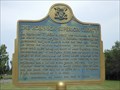 view gallery view gallery NW55.7 km NW55.7 km
|  "THE ROBINSON SUPERIOR TREATY" - Thunder Bay ON "THE ROBINSON SUPERIOR TREATY" - Thunder Bay ON
in Ontario Provincial Plaques This Ontario Provincial Plaque in on the road to Chippawa Park,6.4 km east and south of James Street South on the Fort William First Nation just south of Thunder Bay, Ontario. It's 9.7 km from Hwy 61. posted by: PeterNoG location: Ontario, Canada date approved: 07/18/2012 last visited: 03/01/2020 |
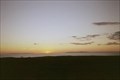
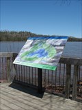 view gallery view galleryW56.3 km |  Lake Superior – at Pigeon River, ON Lake Superior – at Pigeon River, ON
in Natural Lakes This view of Lake Superior is located at Pigeon River, Ontario on the Canadian/US border. posted by: wildernessmama location: Ontario, Canada date approved: 05/28/2013 last visited: 02/29/2020 |
 view gallery view galleryW56.3 km |  Bench at Bay – Pigeon River, ON Bench at Bay – Pigeon River, ON
in Artistic Seating This intricately designed laser-cut seat depicts a horse drawn logging wagon and a small village of log cabins. posted by: wildernessmama location: Ontario, Canada date approved: 05/28/2013 last visited: 02/29/2020 |
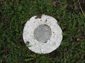
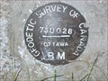 view gallery view galleryW56.5 km |  73U028 73U028
in Canadian Benchmarks Geodetic Survey of Canada benchmark at the border crossing at Pigeon River (Ontario-Minnesota). posted by: msrubble location: Ontario, Canada date approved: 06/22/2011 last visited: never |
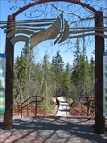 view gallery view galleryW56.6 km |  Boardwalk Trail Boardwalk Trail
in Non-Coastal Boardwalks This boardwalk trail is located in the Pigeon River Provincial Park on the Canadian/US border. posted by: wildernessmama location: Ontario, Canada date approved: 06/02/2013 last visited: 02/29/2020 |
 view gallery view galleryW56.8 km |  ON, Canada / MN, USA on Hwy 61 ON, Canada / MN, USA on Hwy 61
in Border Crossings This Border Crossings on Highway 61 across the Pigeon River is between Ontario, Canada and Minnesota, U.S.A. posted by: PeterNoG location: Minnesota date approved: 07/26/2012 last visited: 02/29/2020 |
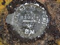 view gallery view galleryW57 km | 73U027 in Canadian Benchmarks Geodetic Survey of Canada benchmark in Pigeon River, Ontario. posted by: msrubble location: Ontario, Canada date approved: 06/22/2011 last visited: 05/23/2013 |
 view gallery view galleryW57 km |  International Boundary Commission - MON 1354 64 International Boundary Commission - MON 1354 64
in U.S. Benchmarks This benchmark can be found in Grand Portage State Park (in Minnesota). The coordinates, N 48° 00.103 W 089° 35.304, are actually for a geocache near the marker. posted by: meralgia location: Minnesota date approved: 06/23/2008 last visited: 02/29/2020 |
|