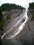
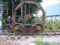
 view gallery view gallery N3.2 km N3.2 km
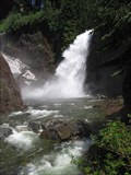
|   Otter Falls Otter Falls
in Waterfalls The third highest waterfall in WA - 1600 feet high! posted by:  Prying Pandora Prying Pandora location: Washington date approved: 06/20/2007 last visited: 08/21/2013 |
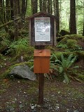 view gallery view gallery W4.5 km W4.5 km
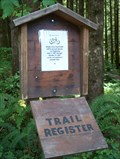
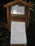
|  Taylor River Trailhead Taylor River Trailhead
in Trail Registers Taylor River Trail Register posted by: Prying Pandora location: Washington date approved: 06/19/2007 last visited: 08/21/2013 |
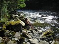 view gallery view galleryW4.7 km |  Taylor River Spot Taylor River Spot
in Free Campsites A great little spot to camp with friends. posted by:  azure azure location: Washington date approved: 07/11/2006 last visited: never |
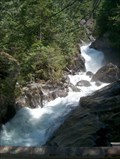 view gallery view gallery S4.8 km S4.8 km
| Dingford Creek Cascades in Waterfalls Large cascading waterfall near the Middle Fork of the Snoqualmie River. posted by: Prying Pandora location: Washington date approved: 06/03/2007 last visited: 08/28/2008 |
 view gallery view galleryW5.1 km | Middle Fork Trail #1003 in Trail Registers Middle Fork of the Snoqualmie River. posted by: Prying Pandora location: Washington date approved: 06/19/2007 last visited: 07/06/2008 |
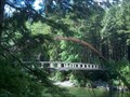 view gallery view galleryW5.1 km |  Middle Fork Snoqualmie River, WA Middle Fork Snoqualmie River, WA
in Pedestrian Suspension Bridges Middle Fork Trail Bridge posted by: Prying Pandora location: Washington date approved: 06/19/2007 last visited: 10/26/2014 |
 view gallery view galleryS15 km | Franklin Falls in Waterfalls An easily accessible and spectacular waterfall located right off I-90, just west of Snoqualmie Pass. posted by: krazykatzen location: Washington date approved: 07/08/2008 last visited: 06/02/2023 |
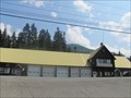 view gallery view galleryS15.3 km |  Snoqualmie Pass Fire & Rescue Snoqualmie Pass Fire & Rescue
in Firehouses This fire station was originally built in the 1930’s as a maintenance shed for the Department of Transportation. posted by: DougK location: Washington date approved: 08/18/2010 last visited: 09/10/2022 |
 view gallery view galleryS15.4 km |  Laconia, former Railroad Station, Snoqualmie WA Laconia, former Railroad Station, Snoqualmie WA
in Signs of History This sign represents local history as well as some artwork located here. posted by: Queens Blessing location: Washington date approved: 07/15/2010 last visited: 09/10/2022 |
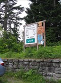
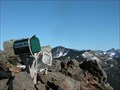
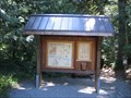
 view gallery view galleryS15.4 km |  Snoqualmie Pass Visitors Center, Washington Snoqualmie Pass Visitors Center, Washington
in 'You Are Here' Maps This You Are Here sign is located just outside the Mt Baker/Snoqualmie/Wenatchee National Forests Visitors Center. posted by: Queens Blessing location: Washington date approved: 07/14/2010 last visited: 08/17/2018 |
 view gallery view galleryS15.4 km |  Snoqualmie Pass Visitor Center, Washington Snoqualmie Pass Visitor Center, Washington
in Ranger Stations This Ranger Station serves the Mt. Baker, Snoqualmie, and Wenatchee National Forests. posted by: Queens Blessing location: Washington date approved: 07/16/2010 last visited: 08/13/2023 |
 view gallery view galleryS15.4 km |  Smokey Bear at Snoqualmie Pass, Washington Smokey Bear at Snoqualmie Pass, Washington
in Smokey Bear Sign Sightings Smokey the Bear must LOVE living here! It is so beautiful, and it must be fun to watch skiers fly down the hill. posted by: Queens Blessing location: Washington date approved: 07/15/2010 last visited: 07/26/2021 |
 view gallery view gallery SW16.6 km SW16.6 km
|  Mailbox Peak Mailbox Peak
in Summit Registers A mailbox on the summit of Mailbox Peak posted by: Mtn Dog location: Washington date approved: 09/07/2005 last visited: 10/21/2021 |
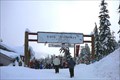 view gallery view galleryS17.1 km |  The Summit Tubing Center - Snoqualmie Pass, Washington The Summit Tubing Center - Snoqualmie Pass, Washington
in Sledding Places A tubing area near the Snoqualmie ski areas at "The Summit". You must use their tubes and time slots are sold in 2 hour allocations starting at 9 am. Rope tows to the top of the hill. posted by: Hikenutty location: Washington date approved: 12/27/2006 last visited: 10/12/2020 |
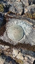
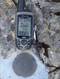 view gallery view galleryW17.7 km |  WA Dept. of Natural Resources Benchmark - Mt. Teneriffe WA Dept. of Natural Resources Benchmark - Mt. Teneriffe
in U.S. Benchmarks DNR benchmark at the summit of Mt. Teneriffe posted by: Prying Pandora location: Washington date approved: 09/11/2007 last visited: 10/21/2021 |
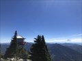
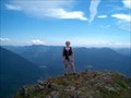 view gallery view galleryW17.7 km |  Mt. Teneriffe Mt. Teneriffe
in Mountain Summits Mt. Teneriffe, above North Bend, WA posted by: Prying Pandora location: Washington date approved: 08/30/2007 last visited: 10/21/2021 |
 view gallery view galleryS17.9 km |  Pratt Lake Trailhead - Snoqualmie Pass, Washington Pratt Lake Trailhead - Snoqualmie Pass, Washington
in Hiking and walking trailheads Located off of NF-9034 near the I-90 exit. posted by: flyingmoose location: Washington date approved: 01/16/2023 last visited: never |
 view gallery view galleryS17.9 km |  Granite Mountain - Snoqualmie Pass, Washington Granite Mountain - Snoqualmie Pass, Washington
in Scenic Hikes Located off of NF-9034 near the I-90 exit. posted by: flyingmoose location: Washington date approved: 01/16/2023 last visited: never |
 view gallery view galleryS18.2 km | John Wayne Pioneer Trail in Rails to Trails The Snoqualmie Tunnel is an abandoned railroad tunnel at Snoqualmie Pass at the border of King County and Kittitas County in Washington State. It is 2.3 miles (3.7 km) long. posted by: ILuvAZ location: Washington date approved: 06/19/2013 last visited: 07/16/2023 |
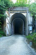 view gallery view galleryS18.2 km |  Snoqualmie Tunnel Snoqualmie Tunnel
in Abandoned Train Tunnels The Snoqualmie Tunnel is an abandoned railroad tunnel at Snoqualmie Pass at the border of King County and Kittitas County in Washington State. It is 2.3 miles (3.7 km) long. posted by: ILuvAZ location: Washington date approved: 06/23/2013 last visited: 07/16/2023 |
 view gallery view gallery NE18.2 km NE18.2 km
| Maloney Ridge Fire Lookout Site BM TS 17-25 - Skykomish WA in U.S. Benchmarks Washington State Highway Department Survey Marker on the Original Maloney Ridge Fire Tower Lookout site. posted by: Winos_Seattle location: Washington date approved: 06/26/2020 last visited: never |
 view gallery view galleryS18.3 km | Asahel Curtis Nature Trail in Hiking and walking trailheads The Asahel Curtis Nature Trail is a 3/4 mile long nature trail. The loop trail passes through one of the last remaining old-growth forest stands within the Snoqualmie Valley Interstate-90 corridor. posted by: Hawaiian Ninja location: Washington date approved: 08/08/2009 last visited: 04/26/2019 |
 view gallery view galleryS18.3 km | Annette Lake Trail in Hiking and walking trailheads The Annette Lake Trail shares the same trailhead as the Asahel Curtis Trail. The Annette Lake Trail is about 4 miles long and is considered a difficult hike because of the steepness in some areas. posted by: Hawaiian Ninja location: Washington date approved: 08/09/2009 last visited: 04/26/2019 |
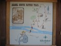
 view gallery view galleryS18.3 km |  Asahel Curtis Nature Trail Asahel Curtis Nature Trail
in Self Guided Walks and Trails This nature trail loop features about a dozen areas with plaques describing plants and trees of interest. The entire loop is about 3/4 miles long. posted by: Hawaiian Ninja location: Washington date approved: 08/12/2009 last visited: 04/26/2019 |
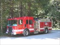 view gallery view galleryS18.3 km | Snoqualmie Pass Fire & Rescue E291 - Snoqualmie Pass, WA in Fire Fighting Vehicles This fire engine was on official business here at the trailhead for the Asahel Curtis Nature Trail. posted by: Hawaiian Ninja location: Washington date approved: 08/08/2009 last visited: never |
|