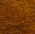
 view gallery view gallery NW2.6 km NW2.6 km
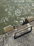
|   ancienne Ancre de Marine,Banaster,Bretagne,France ancienne Ancre de Marine,Banaster,Bretagne,France
in Anchors an old marine anchor posted by:  keillec keillec location: Bretagne, France date approved: 12/17/2020 last visited: 03/13/2021 |
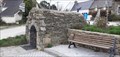
 view gallery view gallery SW3.7 km SW3.7 km
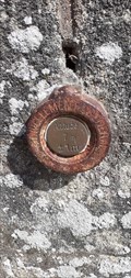
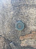
|  Benchmark - La Chapelle de la Pointe de Penvins - Sarzeau, France Benchmark - La Chapelle de la Pointe de Penvins - Sarzeau, France
in French Benchmarks Sur un mur de la chapelle Notre-Dame-de-la-Côte posted by: garenkreiz location: Bretagne, France date approved: 05/28/2013 last visited: 03/29/2021 |
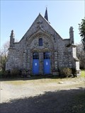
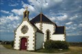 view gallery view gallerySW3.7 km |  Chapelle ND de la Côte - Penvins, France Chapelle ND de la Côte - Penvins, France
in Waychapels [FR] La chapelle Notre-Dame de la Côte, à Penvins, est située au bord de l'océan.
[ENG] The Our-Lady of the Coast chapel, at Penvins, is located at the edge of the ocean. posted by: Chris777 location: Bretagne, France date approved: 09/05/2007 last visited: 12/06/2022 |
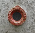
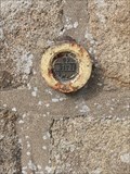
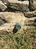
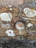
 view gallery view gallerySW3.7 km | Benchmarck - Repère Géodésique - Chapelle Notre-Dame-de-la-Côte - Sarzeau, France in French Benchmarks Borne en granit gravée IGN, avec Azimut de la prise de vue : 175 gr posted by: garenkreiz location: Bretagne, France date approved: 05/28/2013 last visited: 03/29/2021 |
 view gallery view galleryNW3.7 km |  Le Petit-Mont - Arzon, Bretagne, France Le Petit-Mont - Arzon, Bretagne, France
in Remains of Settlements [FR] Le Petit Mont est un cairn situé en Bretagne [EN] The "Petit Mont" is a cairn located in Britany posted by: Tromel location: Bretagne, France date approved: 07/29/2021 last visited: 08/31/2021 |
 view gallery view gallery W5.5 km W5.5 km
|  Fontaine de Landrezac -Sarzeau , France Fontaine de Landrezac -Sarzeau , France
in Natural Springs Cette fontaine se situe à Landrezac sur la commune de Sarzeau. This fountain is located in Landrezac in the town of Sarzeau. posted by: Georgioturino location: Bretagne, France date approved: 01/21/2022 last visited: 12/19/2022 |
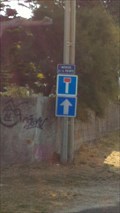 view gallery view gallery E6.3 km E6.3 km
|  Une impasse à sens unique Une impasse à sens unique
in Unintentionally Funny Signs [FR] Pour une même rue, il est indiqué que c'est une impasse (panneau du haut) et que la rue est en sens unique (panneau du bas).
[EN] For the same street, it is indicated that it is an impasse (top) and that the street is in one direction (bottom). posted by: qc2m location: Bretagne, France date approved: 12/11/2018 last visited: 12/12/2018 |
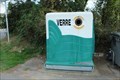 view gallery view galleryW6.8 km |  DO - Château de Suscinio - Sarzeau, France DO - Château de Suscinio - Sarzeau, France
in Places for Recycling [EN] Recycling point for glass. [FR] Point de recyclage pour le verre. posted by: pmaupin location: Bretagne, France date approved: 09/02/2018 last visited: 02/06/2021 |
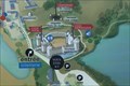 view gallery view galleryW6.9 km |  Vous Etes ici: Château de Suscinio 01 - Sarzeau, France Vous Etes ici: Château de Suscinio 01 - Sarzeau, France
in 'You Are Here' Maps [EN] The indications "you are here" are on an information board in front of Suscinio Castle.
[FR] Les indications "vous êtes ici" se trouve sur un panneau d'information devant le château de Suscinio. posted by: pmaupin location: Bretagne, France date approved: 09/02/2018 last visited: 02/06/2021 |
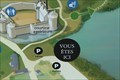 view gallery view galleryW6.9 km | Vous Etes ici: Château de Suscinio 02 - Sarzeau, France in 'You Are Here' Maps [EN] The indications "you are here" are on an information board on the parking lot of Suscinio Castle.
[FR] Les indications "vous êtes ici" se trouve sur un panneau d'information sur le parking du château de Suscinio. posted by: pmaupin location: Bretagne, France date approved: 09/02/2018 last visited: 02/06/2021 |
 view gallery view galleryW6.9 km |  Château de Suscinio - Sarzeau, France Château de Suscinio - Sarzeau, France
in Wikipedia Entries [EN] The castle of Suscinio, built at the end of the Middle Ages (in the 13th and the second half of the 14th century), residence of the dukes of Brittany, is located at the edge of Mor Braz (Atlantic Ocean) in the town of Sarzeau (Morbihan) .
[FR] Le château de Suscinio, construit à la fin du Moyen Âge (au XIIIe et dans la seconde moitié du XIVe siècle), résidence des ducs de Bretagne, est situé au bord de Mor braz (océan Atlantique) dans la commune de Sarzeau (Morbihan). posted by: pmaupin location: Bretagne, France date approved: 08/14/2018 last visited: 12/06/2022 |
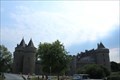 view gallery view galleryW6.9 km |  Château de Suscinio - Sarzeau, France Château de Suscinio - Sarzeau, France
in Castles [EN] The castle of Suscinio, built at the end of the Middle Ages (in the 13th and the second half of the 14th century), residence of the dukes of Brittany, is located at the edge of Mor Braz (Atlantic Ocean) in the town of Sarzeau (Morbihan) . [FR] Le château de Suscinio, construit à la fin du Moyen Âge (au XIIIe et dans la seconde moitié du XIVe siècle), résidence des ducs de Bretagne, est situé au bord de Mor braz (océan Atlantique) dans la commune de Sarzeau (Morbihan). posted by: pmaupin location: Bretagne, France date approved: 08/14/2018 last visited: 12/06/2022 |
 view gallery view galleryW6.9 km |  Château de Suscinio - Sarzeau, France Château de Suscinio - Sarzeau, France
in Monuments Historiques Français [FR] Le château de Suscinio, construit à la fin du Moyen Âge (au XIIIe et dans la seconde moitié du XIVe siècle), résidence des ducs de Bretagne, est situé au bord de Mor braz (océan Atlantique) dans la commune de Sarzeau (Morbihan).[EN] The castle of Suscinio, built at the end of the Middle Ages (in the 13th and the second half of the 14th century), residence of the dukes of Brittany, is located at the edge of Mor Braz (Atlantic Ocean) in the town of Sarzeau (Morbihan) . posted by: pmaupin location: Bretagne, France date approved: 08/17/2018 last visited: 12/06/2022 |
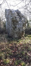 view gallery view galleryW6.9 km |  Menhir de Coporh (ou Prat Quilio), Sarzeau- Bretagne , France Menhir de Coporh (ou Prat Quilio), Sarzeau- Bretagne , France
in Megalithic Monuments Menhir de Coporh dans la commune de Sarzeau. Menhir de Coporh in the commune of Sarzeau. posted by: Georgioturino location: Bretagne, France date approved: 04/11/2022 last visited: 12/19/2022 |
 view gallery view gallery NE7.4 km NE7.4 km
|  Chapelle de Brouël , Ambon - France Chapelle de Brouël , Ambon - France
in This Old Church La chapelle Notre Dame de Mille Secours, située à l’entrée de Brouël en venant de la D20, à l’ouest d’Ambon, date de 1580 . La chapelle Notre-Dame des Mille Secours, située à l’entrée de Brouël en venant de la D20, à l’ouest d’Ambon, date de 1580. posted by: Georgioturino location: Bretagne, France date approved: 12/31/2021 last visited: never |
 view gallery view galleryNE7.4 km | Chapelle de Brouël , Ambon -France in Monuments Historiques Français La chapelle Notre Dame de Mille Secours, située à l’entrée de Brouël en venant de la D20, à l’ouest d’Ambon, date de 1580 . La chapelle Notre-Dame des Mille Secours, située à l’entrée de Brouël en venant de la D20, à l’ouest d’Ambon, date de 1580. posted by: Georgioturino location: Bretagne, France date approved: 12/29/2021 last visited: never |
 view gallery view galleryNW9 km | Repère de Nivellement-Eglise-St Armel ,France in French Benchmarks Ce repère est situé sur l'église de Saint-Armel.
This marker is located on the church of Saint-Armel. posted by: Georgioturino location: Bretagne, France date approved: 01/17/2023 last visited: never |
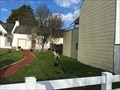
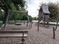 view gallery view galleryW10.1 km |  Aire de Jeux du Bois de la Grée, Sarzeau - France Aire de Jeux du Bois de la Grée, Sarzeau - France
in Public Playgrounds Cette aire de jeux se situe près du Bois de la Grée, derrière le cimetière de Sarzeau . Cette aire de jeux est située près du bois de la Grée, derrière le cimetière Sarzeau. posted by: Georgioturino location: Bretagne, France date approved: 11/22/2022 last visited: never |
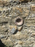
 view gallery view galleryW10.3 km | Benchmark - Une Croix - Sarzeau, France in French Benchmarks Voici un repère de nivellement posé sur une croix de granit près du Château de Kerthomas à Sarzeau.
Here is a levelling marker placed on a granite cross near Kerthomas Castle in Sarzeau. posted by: Georgioturino location: Bretagne, France date approved: 04/16/2021 last visited: never |
 view gallery view galleryNW10.8 km | Repère de tirant d'air - SAINT-MICHEL - D -Montsarrac, France in French Benchmarks REPÈRE DE TIRANT D'AIR
Ce repère fait partie du groupe de repères SAINT-MICHEL posted by: keillec location: Bretagne, France date approved: 04/28/2018 last visited: 04/28/2018 |
 view gallery view galleryNW10.8 km | Repère Shom - SAINT-MICHEL - A - Montsarrac, France in French Benchmarks REPERE SHOM (SERVICE HYDROGRAPHIQUE ET OCEANOGRAPHIQUE DE LA MARINE) posted by: keillec location: Bretagne, France date approved: 04/28/2018 last visited: 04/28/2018 |
 view gallery view galleryNW10.8 km | Repère Shom - SAINT-MICHEL - B -Montsarrac, France in French Benchmarks REPERE SHOM (SERVICE HYDROGRAPHIQUE ET OCEANOGRAPHIQUE DE LA MARINE)
Ce repère fait partie du groupe de repères SAINT-MICHEL posted by: keillec location: Bretagne, France date approved: 04/28/2018 last visited: 04/28/2018 |
 view gallery view galleryNW10.9 km | O.K.P3 - 129 "BOT-SPERNEN" - Montsarrac, France in French Benchmarks M REPERE CYLINDRIQUE DU NIVELLEMENT GENERAL posted by: keillec location: Bretagne, France date approved: 04/28/2018 last visited: 04/28/2018 |
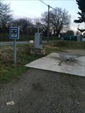 view gallery view gallery N11.1 km N11.1 km
|  aire camping Car Noyalo-Bretagne-France aire camping Car Noyalo-Bretagne-France
in Free Overnight RV Parking Locations FR / Noyalo motorhome area, equipped with a WC emptying terminal and a water tap posted by: keillec location: Bretagne, France date approved: 01/10/2021 last visited: 03/11/2021 |
 view gallery view galleryNW11.3 km | O.K.P3 - 130 - Sené, France in French Benchmarks M REPERE CYLINDRIQUE DU NIVELLEMENT GENERAL
Complément :
SERVICE HYDROGRAPHIQUE ET OCEANOGRAPHIQUE DE LA MARINE
Ce repère fait partie du groupe de repères SAINT-MICHEL. posted by: keillec location: Bretagne, France date approved: 04/28/2018 last visited: 04/28/2018 |
|