 view gallery view gallery NE4.3 km NE4.3 km
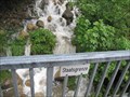
|   Staatsgrenze Deutschland-Österreich, Balderschwang, Lk Oberallgäu Staatsgrenze Deutschland-Österreich, Balderschwang, Lk Oberallgäu
in Border Crossings Staatsgrenze Deutschland-Österreich bei Balderschwang.
---
State border Germany-Austria in the near of Balderschwang. posted by:  lumbricus lumbricus location: Bayern, Germany date approved: 07/20/2011 last visited: 10/06/2016 |
 view gallery view gallery NW6.4 km NW6.4 km
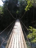
|  "Hängebrücke" - Vorarlberg, Austria "Hängebrücke" - Vorarlberg, Austria
in Pedestrian Suspension Bridges Modern suspension brigde for hikers in Vorarlberg (Austria) posted by:  Gavriel Gavriel location: Vorarlberg, Austria date approved: 11/06/2005 last visited: never |
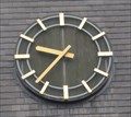
 view gallery view galleryNE6.6 km |  Kirchturmuhr, Sankt-Anton-Kirche, Balderschwang, Lk Oberallgäu Kirchturmuhr, Sankt-Anton-Kirche, Balderschwang, Lk Oberallgäu
in Town Clocks Uhr am Kirchturm der Sankt-Anton-Kirche in Balderschwang.
---
Clock at the St.-Anton church tower in Balderschwang. posted by: lumbricus location: Bayern, Germany date approved: 07/20/2011 last visited: never |
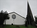
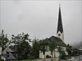 view gallery view galleryNE6.6 km |  Katholische Pfarrkirche St. Antonius - Balderschwang, Bavaria, Germany Katholische Pfarrkirche St. Antonius - Balderschwang, Bavaria, Germany
in Roman Catholic Churches Katholische Pfarrkirche St. Antonius in Balderschwang. --- Catholic parish church St. Antonius in Balderschwang. posted by: lumbricus location: Bayern, Germany date approved: 09/02/2015 last visited: never |
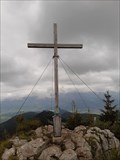
 view gallery view gallery N6.9 km N6.9 km
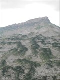
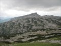
|  Eineguntkopf bzw. Rohnehöhe - 1639 m - Bavaria, Germany Eineguntkopf bzw. Rohnehöhe - 1639 m - Bavaria, Germany
in Mountain Summits "Der Eineguntkopf, beziehungsweise die Rohnehöhe ist ein Berg der Nagelfluhkette am Nordrand der Allgäuer Alpen. Er hat eine Höhe von 1639 m." Wikipedia posted by: lumbricus location: Bayern, Germany date approved: 12/17/2020 last visited: never |
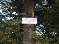
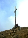
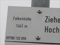 view gallery view galleryN6.9 km |  Falkenhütte, 1441m - Steibis, Oberstaufen, Lk Oberallgäu, Bayern, D Falkenhütte, 1441m - Steibis, Oberstaufen, Lk Oberallgäu, Bayern, D
in Elevation Signs Falkenhütte 1441m
---
Falkebhütte 4728 feet posted by: lumbricus location: Bayern, Germany date approved: 09/09/2011 last visited: never |
 view gallery view gallery SE8 km SE8 km
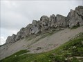
|  Gottesacker, Oberstdorf, Lk Oberallgäu Gottesacker, Oberstdorf, Lk Oberallgäu
in Wikipedia Entries Karstlandschaft "Gottesackerplateau" im Allgäu.
---
Karst landscape "Gottesackerplateau", Allgäu. posted by: lumbricus location: Bayern, Germany date approved: 08/19/2011 last visited: 02/25/2014 |
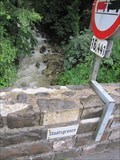
 view gallery view gallerySE8.2 km |  Wasserscheide - Rohrmoos, Bavaria, Germany Wasserscheide - Rohrmoos, Bavaria, Germany
in Watershed Markers and Monuments Auf 1.120 m befindet sich die europäische Wasserscheide im Rohrmoos. --- European watershed/drainage divide here at Rohrmoos. posted by: lumbricus location: Bayern, Germany date approved: 09/28/2017 last visited: never |
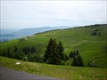 view gallery view gallery W8.4 km W8.4 km
|  Panorama-Wanderweg Andelsbuch-Niedere - Bezau, Vorarlberg, Austria Panorama-Wanderweg Andelsbuch-Niedere - Bezau, Vorarlberg, Austria
in Scenic Hikes Panorama-Wanderweg Andelsbuch-Niedere - Bezau, Vorarlberg, Austria posted by: luzzi-reloaded location: Vorarlberg, Austria date approved: 10/14/2011 last visited: 07/06/2013 |
 view gallery view gallerySE8.4 km | Gottesacker Scharte, 1967m, Oberstdorf, Lk Oberallgäu in Elevation Signs Schild an der Gottesacker Scharte bei 1967m.
---
Sign at the Gottesacker Scharte (6453feet). posted by: lumbricus location: Bayern, Germany date approved: 07/28/2011 last visited: never |
 view gallery view gallerySE8.4 km |  TP Torkopfscharte, Gottesacker, Oberstdorf, Bayern TP Torkopfscharte, Gottesacker, Oberstdorf, Bayern
in German Trigonometric Points Der TP liegt bei der Torkopfscharte mit Blick über den Gottesacker.
---
This German Trigpoint is located at the Torkopfscharte near the Gottesackerplateau. posted by: lumbricus location: Bayern, Germany date approved: 07/27/2011 last visited: never |
 view gallery view gallerySE8.5 km | Obere Gottesackerwände, Oberstdorf, Lk Oberallgäu in Scenic Overlooks Ausblick von den "Oberen Gottesackerwände".
---
Great view from the top of the "Oberen Gottesackerwände". posted by: lumbricus location: Bayern, Germany date approved: 07/28/2011 last visited: 02/25/2014 |
 view gallery view gallerySE8.7 km | Obere Gottesackerwände, Oberstdorf, Lk Oberallgäu in Wikipedia Entries "Obere Gottesackerwände" im Allgäu. --- "Oberen Gottesackerwände" in Allgäu. posted by: lumbricus location: Bayern, Germany date approved: 08/19/2011 last visited: 02/25/2014 |
 view gallery view gallery S9 km S9 km
| Diedamskopf, Vorarlberg - Austria in Mountain Summits Diedamskopf in Vorarlberg - Österreich posted by: jotheonly location: Vorarlberg, Austria date approved: 01/31/2016 last visited: 01/31/2016 |
 view gallery view galleryS9 km |  Webcam Diedamskopf, Vorarlberg - Austria Webcam Diedamskopf, Vorarlberg - Austria
in Web Cameras Webcam für persönliche Fotos auf der Gipfelstation des Diedamskopfes.
Webcam for personal photos on the summit station of the Diedamskopf. posted by: jotheonly location: Vorarlberg, Austria date approved: 02/05/2016 last visited: 05/02/2016 |
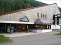 view gallery view galleryN9.3 km |  Hochgratbahn - Steibis, BY, Germany Hochgratbahn - Steibis, BY, Germany
in Aerial Lifts Hochgradbahn bei Steibis im Oberallgäu posted by: jotheonly location: Bayern, Germany date approved: 10/10/2016 last visited: 06/25/2017 |
 view gallery view gallery E10.5 km E10.5 km
| Riedbergpass, 1420m, Grasgehren, Lk Oberallgäu in Wikipedia Entries Riedbergpass 1420 m über NN. --- Riedbergpass 4659 feet above sea level. posted by: lumbricus location: Bayern, Germany date approved: 08/19/2011 last visited: 10/07/2016 |
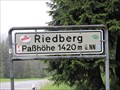 view gallery view galleryE10.5 km | Riedbergpass, 1420m, Grasgehren, Lk Oberallgäu in Elevation Signs Riedbergpass 1420 m über NN.
---
Riedbergpass 4659 feet above sea level. posted by: lumbricus location: Bayern, Germany date approved: 07/20/2011 last visited: 10/07/2016 |
 view gallery view galleryE11.1 km | Besler - 1679m - Bavaria, Germany in Mountain Summits The Besler is a smaller mountain, only 1679 meters high. posted by: GPSKaninchen location: Bayern, Germany date approved: 08/19/2021 last visited: never |
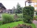 view gallery view galleryN11.4 km |  Brunnen in Steibis - Steibis, Oberstaufen, Lk Oberallgäu, Bayern, D Brunnen in Steibis - Steibis, Oberstaufen, Lk Oberallgäu, Bayern, D
in Fountains Brunnen in Steibis.
---
Fountain in Steibis. posted by: lumbricus location: Bayern, Germany date approved: 09/09/2011 last visited: never |
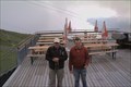
 view gallery view galleryN11.4 km |  Die drei Dorfmusikanten, Steibis, Oberstaufen, Lk Oberallgäu Die drei Dorfmusikanten, Steibis, Oberstaufen, Lk Oberallgäu
in Figurative Public Sculpture Die drei Dorfmusikanten in Steibis.
---
The three village musicians in Steibis. posted by: lumbricus location: Bayern, Germany date approved: 07/28/2011 last visited: 10/06/2016 |
 view gallery view galleryNW11.4 km | Staatsgrenze Deutschland-Österreich, Aach , Lk Oberallgäu in Border Crossings Staatsgrenze Deutschland-Österreich bei Aach. --- State border Germany-Austria in the near of Aach. posted by: lumbricus location: Bayern, Germany date approved: 07/20/2011 last visited: 10/06/2016 |
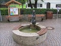 view gallery view galleryNW11.6 km | Brunnen an der Kirche, Aach, Lk Oberallgäu in Fountains Brunnen an der Kirche in Aach bei Oberstaufen.
---
Fountain by the church in Aach near Oberstaufen. posted by: lumbricus location: Bayern, Germany date approved: 07/20/2011 last visited: 08/30/2019 |
 view gallery view galleryN11.6 km | Kirche "Verklärung Christi" - Steibis, Lk Oberallgäu. Bayern, D in Roman Catholic Churches Katholische Kirche "Verklärung Christi" in Steibis. ---Catholic church "Verklärung Christi" in Steibis. posted by: lumbricus location: Bayern, Germany date approved: 09/09/2011 last visited: never |
 view gallery view galleryN11.6 km | Uhr an der Kirche "Verklärung Christi" - Steibis, Lk Oberallgäu. Bayern, D in Town Clocks Uhr am Kirchturm der Kirche "Verklärung Christi" in Steibis.
---
Clock on the church tower at the "Verklärung Christi" church in Steibis. posted by: lumbricus location: Bayern, Germany date approved: 09/09/2011 last visited: never |
|