 view gallery view gallery SW2.6 km SW2.6 km
|  ") Plaque de l'église de Saint-Marc-du-Lac-Long - Saint-Marc-du-Lac-Long, Québec Plaque de l'église de Saint-Marc-du-Lac-Long - Saint-Marc-du-Lac-Long, Québec
in Histoire du Quebec (Quebec Historical Markers) Cette plaque est fixée au mur avant de l'église de Saint-Marc-du-Lac-Long, à Saint-Marc-du-Lac-Long. posted by:  Weathervane Weathervane location: Québec, Canada date approved: 03/01/2019 last visited: never |
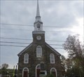
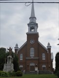
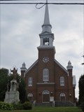
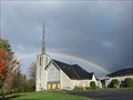
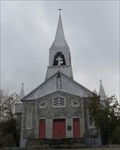 view gallery view gallerySW2.6 km | Église de Saint-Marc-du-Lac-Long - Saint-Marc-du-Lac-Long, Québec in Histoire du Quebec (Quebec Historical Markers) L'Église de Saint-Marc-du-Lac-Long, érigée entre 1956 et 1957, est située sur la rue de l'église à Saint-Marc-du-Lac-Long. posted by: Weathervane location: Québec, Canada date approved: 03/01/2019 last visited: never |
 view gallery view gallery E11.1 km E11.1 km
| Pont Romain-Caron - Saint-Jean-de-la-Lande, Québec in Histoire du Quebec (Quebec Historical Markers) Le pont couvert Romain-Caron, construit en 1940, est situé sur la route du Lac-Baker à l'intersection du sixième rang, enjambant le petit ruisseau Baker. posted by: Weathervane location: Québec, Canada date approved: 09/08/2014 last visited: never |
 view gallery view gallery W13.8 km W13.8 km
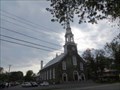
| Église de Saint-Joseph-de-la-Rivière-Bleue - Rivière Bleue, Québec in Histoire du Quebec (Quebec Historical Markers) L'Église de Saint-Joseph-de-la-Rivière-Bleue, érigée entre 1918 et 1920, est située sur la rue Saint-Pierre, à Riviere Bleue. posted by: Weathervane location: Québec, Canada date approved: 02/28/2019 last visited: never |
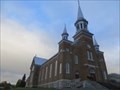 view gallery view galleryW13.8 km |  Église de Saint-Joseph-de-la-Rivière-Bleue - Rivière Bleue, Québec Église de Saint-Joseph-de-la-Rivière-Bleue - Rivière Bleue, Québec
in This Old Church L'Église de Saint-Joseph-de-la-Rivière-Bleue, érigée en 1918, est située sur la rue Saint-Pierre, à Riviere Bleue. The Church of Saint-Joseph-de-la-Rivière-Bleue, erected in 1918, is located on rue Saint-Pierre, in Riviere Bleue. posted by: Weathervane location: Québec, Canada date approved: 12/19/2020 last visited: never |
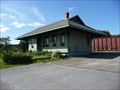
 view gallery view galleryW14 km | Gare de Rivière-Bleue - Rivière-Bleue, Québec in Histoire du Quebec (Quebec Historical Markers) La gare de Rivière-Bleue est une infrastructure d'accueil érigée en 1913. Le bâtiment s'inspire d'un modèle de petites gares ferroviaires utilisé par la compagnie de chemin de fer National Transcontinental dans l'est du pays, durant la décennie 1910. posted by: Weathervane location: Québec, Canada date approved: 02/28/2019 last visited: never |
 view gallery view gallery SE21.4 km SE21.4 km
| Église de - Saint-François-Xavier - Church - Saint-François, Nouveau/New Brunswick in Roman Catholic Churches L'Église de Saint-François-Xavier, complétée en 1929, est située sur la rue Commerciale, à Saint-François. The Church of Saint-François-Xavier, completed in 1929, is located on Commerciale Street, in Saint-François. posted by: Weathervane location: New Brunswick, Canada date approved: 03/02/2019 last visited: never |
 view gallery view gallery NE23.3 km NE23.3 km
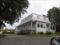
| Ancien presbytère de Dégelis - Dégelis, Québec in Histoire du Quebec (Quebec Historical Markers) L'ancien presbytère de Dégelis, construit entre 1950-51, est situé sur l'avenue Principale à Dégelis. posted by: Weathervane location: Québec, Canada date approved: 03/28/2019 last visited: 07/22/2019 |
 view gallery view galleryNE23.3 km | Église de Sainte-Rose - Dégelis, Québec in Histoire du Quebec (Quebec Historical Markers) L'Église de Sainte-Rose, conçue par l'architecte Joseph-Pierre Ouellet, et construite entre 1904-1905, est située sur la rue Principale, à Dégelis. posted by: Weathervane location: Québec, Canada date approved: 03/26/2019 last visited: 07/22/2019 |
 view gallery view galleryNE23.3 km | Église de Sainte-Rose - Dégelis, Québec in This Old Church L'Église de Sainte-Rose, construite entre 1904-1905, est située sur la rue Principale, à Dégelis. Saint-Rose's Church, built between 1904 and 1905, in located on Principale Street, in Dégelis. posted by: Weathervane location: Québec, Canada date approved: 12/23/2020 last visited: never |
 view gallery view galleryNE23.7 km |  Dégelis, Qc Longeron,France Dégelis, Qc Longeron,France
in Sister City Monuments Dégelis Longeron posted by: SCALAIRE location: Québec, Canada date approved: 08/27/2013 last visited: 10/12/2014 |
 view gallery view galleryNE23.8 km |  Tim Hortons - Avenue de I'Accueil - Dégelis, QC Tim Hortons - Avenue de I'Accueil - Dégelis, QC
in Tim Horton's Restaurants Located as part of the service station Petro Canada. posted by: nomadwillie location: Québec, Canada date approved: 01/06/2018 last visited: 08/16/2021 |
 view gallery view gallery N24.1 km N24.1 km
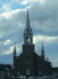
| Presbytère de Notre-Dame-du-Lac - Témiscouata-sur-le-Lac, Québec in Histoire du Quebec (Quebec Historical Markers) Le presbytère de Notre-Dame-du-Lac, construit entre 1873 et 1875, est situé à gauche de l'église de Notre-Dame-du-Lac, sur la rue du Chanoine-Blanchet, à Témiscouata-Sur-le-Lac, Québec posted by: Weathervane location: Québec, Canada date approved: 03/28/2019 last visited: never |
 view gallery view galleryN24.3 km | Église de Notre-Dame-du-Lac - Témiscouata-sur-le-Lac, Québec in Histoire du Quebec (Quebec Historical Markers) L'Église de Notre-Dame-du-Lac, conçue par l'architecte François Florentin Soucy, et construite entre 1858 et 1933, est située sur la rue du Chanoine-Blanchet, à Notre-Dame-du-Lac. posted by: Weathervane location: Québec, Canada date approved: 03/26/2019 last visited: never |
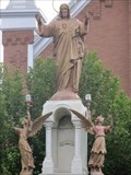 view gallery view galleryN24.3 km | Monument du Sacré-Coeur - Témiscouata-sur-le-Lac - Québec in Histoire du Quebec (Quebec Historical Markers) Ce monument du Sacré-Coeur est situé en avant de l'église de Notre-Dame-du-Lac, à Témiscouata-sur-le-Lac. posted by: Weathervane location: Québec, Canada date approved: 03/28/2019 last visited: never |
 view gallery view galleryN24.3 km |  Anges Gardiens - Guardian Angels - Témiscouata-sur-le-Lac, Québec Anges Gardiens - Guardian Angels - Témiscouata-sur-le-Lac, Québec
in Epic Beings and Creatures Ces anges gardiens sont situés à la base du monument du Sacré-coeur et en avant de l'église de Notre-Dame-du-Lac. These Guardian Angels are located at the base of the Sacred-Heart monument and in front of the Our Lady of the Lake Church. posted by: Weathervane location: Québec, Canada date approved: 03/30/2019 last visited: never |
 view gallery view galleryN24.3 km | Église de Notre-Dame-du-Lac - Témiscouata-sur-le-Lac, Québec in This Old Church L'Église de Notre-Dame-du-Lac, construite entre 1873 et 1875, est située sur la rue du Chanoine-Blanchet, à Notre-Dame-du-Lac. The Church of Notre-Dame-du-Lac, built between 1873 and 1975, is located on rue du Chanoine-Blanchet, in Notre-Dame-du-Lac. posted by: Weathervane location: Québec, Canada date approved: 12/18/2020 last visited: never |
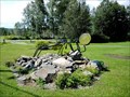 view gallery view galleryNE25.6 km |  Grosse Mouche sur la 295-Dégelis-QC-Canada Grosse Mouche sur la 295-Dégelis-QC-Canada
in Insect Sculptures Une Vraie Grosse Mouche le long de la 295.
A True Big Fly along the 295. posted by: ARZEL_QC location: Québec, Canada date approved: 10/13/2017 last visited: 07/07/2019 |
 view gallery view gallerySE25.7 km | Église - Saint-François-d’Assise - Church - Clair - Nouveau/New Brunswick in Roman Catholic Churches Située sur la rue principale dans le village de Clair, l’église Saint-François-d’Assise se retrouve sur les rives du fleuve Saint-Jean. The church of Saint-François-d’Assise sits on the banks of the Saint-John River, in the village of Clair. posted by: Weathervane location: New Brunswick, Canada date approved: 03/01/2019 last visited: never |
 view gallery view gallerySE26.2 km |  Fort Kent - Fort Kent ME Fort Kent - Fort Kent ME
in U.S. National Register of Historic Places Fort Kent is a site significant for its association with the Aroostook War.
It was declared a National Historic Landmark in 1973.
It is located about 0.75 miles southwest of the town of Fort Kent, Maine.
posted by: nomadwillie location: Maine date approved: 07/28/2009 last visited: 08/19/2012 |
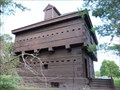 view gallery view gallerySE26.2 km |  Fort Kent - Fort Kent ME Fort Kent - Fort Kent ME
in Historic Forts Constructed 1838-1840, this is the only extant fortification of the Aroostook "War" (1838-1839), the conflict that climaxed the Northeast border disputes with Great Britain following the War of 1812. posted by: nomadwillie location: Maine date approved: 10/12/2009 last visited: 08/19/2012 |
 view gallery view gallerySE26.2 km |  Fort Kent (fort) Fort Kent (fort)
in Wikipedia Entries Fort Kent is a site significant for its association with the Aroostook War. It was declared a National Historic Landmark in 1973. It is located about 0.75 miles southwest of the town of Fort Kent, Maine.
posted by: nomadwillie location: Maine date approved: 12/14/2009 last visited: 08/19/2012 |
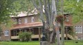
 view gallery view gallerySE26.2 km | Fort Kent Railroad Station in Wikipedia Entries The Fort Kent RR Station was listed in 1989. It is at the junction of Main and Market Streets in Fort Kent, ME posted by: nomadwillie location: Maine date approved: 12/14/2009 last visited: 07/20/2009 |
 view gallery view gallerySE26.2 km | Fort Kent Railroad Station - Fort Kent ME in U.S. National Register of Historic Places The Fort Kent RR Station was listed in 1989. It is at the junction of Main and Market Streets in Fort Kent, ME posted by: nomadwillie location: Maine date approved: 07/28/2009 last visited: 07/20/2009 |
 view gallery view gallerySE26.2 km |  Fort Kent Railroad Station - Fort Kent ME Fort Kent Railroad Station - Fort Kent ME
in Train Stations/Depots The Fort Kent RR Station was listed in 1989. It is at the junction of Main and Market Streets in Fort Kent, ME posted by: nomadwillie location: Maine date approved: 12/14/2009 last visited: 07/20/2009 |
|