 view gallery view gallery SE4.8 km SE4.8 km
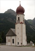
|   Wallfahrtskirche Bschlabs, Tirol, Austria Wallfahrtskirche Bschlabs, Tirol, Austria
in This Old Church Wallfahrtskirche Bschlabs, Tirol, Austria posted by:  luzzi-reloaded luzzi-reloaded location: Tirol, Austria date approved: 05/20/2012 last visited: 05/20/2012 |
 view gallery view gallerySE4.8 km |  Wallfahrtskirche Bschlabs, Tirol, Austria Wallfahrtskirche Bschlabs, Tirol, Austria
in Austrian and Swiss National Heritage Sites Wallfahrtskirche Bschlabs, Tirol, Austria posted by: luzzi-reloaded location: Tirol, Austria date approved: 05/26/2012 last visited: 05/26/2012 |
 view gallery view gallerySE4.8 km | Wallfahrtskirche Bschlabs, Tirol, Austria in Roman Catholic Churches Wallfahrtskirche Bschlabs, Tirol, Austria posted by: luzzi-reloaded location: Tirol, Austria date approved: 03/20/2012 last visited: 03/20/2012 |
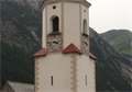 view gallery view gallerySE4.8 km |  Uhr Wallfahrtskirche Bschlabs, Tirol, Austria Uhr Wallfahrtskirche Bschlabs, Tirol, Austria
in Town Clocks Uhr Wallfahrtskirche Bschlabs, Tirol, Austria posted by: luzzi-reloaded location: Tirol, Austria date approved: 03/20/2012 last visited: 03/20/2012 |
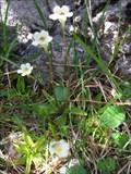 view gallery view gallerySE9 km |  Alpine Butterwort - Tirol, Austria Alpine Butterwort - Tirol, Austria
in Carnivorous Plant Localities Pinguicula alpina, also known as the alpine butterwort, is species of carnivorous plant native to high latitudes and altitudes throughout Eurasia. posted by: RakeInTheCache location: Tirol, Austria date approved: 06/10/2007 last visited: 09/27/2009 |
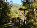 view gallery view gallery N10.9 km N10.9 km
|  Hängebrücke Forchach - Tirol, Austria Hängebrücke Forchach - Tirol, Austria
in Hiking Path Footbridges Hängebrücke Forchach - Tirol, Austria posted by: luzzi-reloaded location: Tirol, Austria date approved: 10/13/2011 last visited: 02/16/2012 |
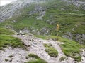
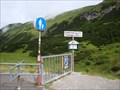 view gallery view gallerySE11.9 km |  Hahntenjoch 1894m - Tirol, Austria Hahntenjoch 1894m - Tirol, Austria
in Elevation Signs Hahntenjoch 1894m - Tirol, Austria posted by: luzzi-reloaded location: Tirol, Austria date approved: 04/26/2012 last visited: 07/12/2014 |
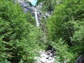 view gallery view gallery NW12.4 km NW12.4 km
|  Täschlefall - Hintestein, Bayern, Germany Täschlefall - Hintestein, Bayern, Germany
in Waterfalls The Täschlefall is in the Ostrachtal (East Ach Valley) in southern Bayern, in the Allgäu Alps. It is almost in Austria. posted by:  Lightnin Bug Lightnin Bug location: Bayern, Germany date approved: 10/09/2022 last visited: never |
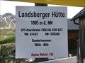 view gallery view galleryN12.4 km | Höhenmarke Landsberger Hütte, Österreich 1805 Meter in Elevation Signs Höhenmarke der Landsberger Hütte posted by: ede-v location: Tirol, Austria date approved: 06/16/2017 last visited: 06/15/2012 |
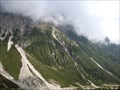
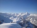
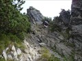 view gallery view gallerySE13 km |  Ruhegebiet Muttekopf Gosau, Tirol, Austria Ruhegebiet Muttekopf Gosau, Tirol, Austria
in Places of Geologic Significance Ruhegebiet Muttekopf Gosau, Tirol, Austria posted by: luzzi-reloaded location: Tirol, Austria date approved: 02/19/2012 last visited: 02/19/2012 |
 view gallery view gallerySE13 km |  Muttekopfhütte Imst, Tirol. Austria Muttekopfhütte Imst, Tirol. Austria
in Scenic Hikes Muttekopfhütte Imst, Tirol. Austria posted by: luzzi-reloaded location: Tirol, Austria date approved: 10/28/2011 last visited: 02/16/2012 |
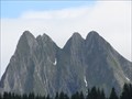 view gallery view gallery W14.3 km W14.3 km
|  Höfats - Oberstdorf, Lk Oberallgäu, Bayern, D Höfats - Oberstdorf, Lk Oberallgäu, Bayern, D
in Wikipedia Entries Die Höfats ist ein 2.259m hoher Berg in den Allgäuer Alpen. --- The "Höfats" is a 7411ft high mountain in the Allgäu Alps. posted by: lumbricus location: Bayern, Germany date approved: 10/22/2011 last visited: never |
 view gallery view gallerySE14.3 km | Jägersteig Hochimst - Tirol, Austria in Scenic Hikes Jägersteig Hochimst - Tirol, Austria posted by: luzzi-reloaded location: Tirol, Austria date approved: 10/26/2011 last visited: 02/16/2012 |
 view gallery view galleryW15.3 km |  Grenze Deutschland-Österreich auf dem Fernwanderweg E5 Grenze Deutschland-Österreich auf dem Fernwanderweg E5
in Border Crossings Wandert man den Fernwanderweg E5 von Obersdorf, kommt man nach der Kemptner Hütte an dieser Stelle nach Österreich. posted by: ATW-Basti location: Bayern, Germany date approved: 08/03/2014 last visited: 07/15/2020 |
 view gallery view galleryN16.6 km | Tannheim - Tyrol, Austria in Scenic Overlooks Tannheim - Tyrol, Austria posted by: luzzi-reloaded location: Tirol, Austria date approved: 03/19/2015 last visited: 06/15/2012 |
 view gallery view galleryN16.6 km |  LARGEST -- Summitbook of the Alps - Tannheim, Tyrol, Austria LARGEST -- Summitbook of the Alps - Tannheim, Tyrol, Austria
in Superlatives LARGEST -- Summitbook of the Alps - Tannheim, Tyrol, Austria posted by: luzzi-reloaded location: Tirol, Austria date approved: 04/16/2015 last visited: 06/15/2012 |
 view gallery view galleryN16.6 km | Neunerköpfle - Tannheim, Tyrol, Austria in Wikipedia Entries Neunerköpfle - Tannheim, Tyrol, Austria posted by: luzzi-reloaded location: Tirol, Austria date approved: 04/17/2015 last visited: 06/15/2012 |
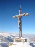 view gallery view galleryN16.6 km |  Gipfelkreuz Neunerköpfl - Tannheim, Tyrol, Austria Gipfelkreuz Neunerköpfl - Tannheim, Tyrol, Austria
in Christian Crosses Gipfelkreuz Neunerköpfl - Tannheim, Tyrol, Austria posted by: luzzi-reloaded location: Tirol, Austria date approved: 04/14/2015 last visited: 06/15/2012 |
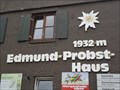 view gallery view galleryNW16.6 km | 1932m - Edmund-Probst-Haus Oberstdorf, Germany, BY in Elevation Signs This elevation sign is at the Edmund-Probst-Haus near to the mountain station of the Nebelhornbahn Section II (aerial railway) called 'Höfatsblick'. It is located near to Oberstdorf, Germany, Bayern. posted by: Tante.Hossi location: Bayern, Germany date approved: 08/09/2011 last visited: 02/28/2014 |
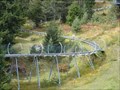
 view gallery view galleryNW16.6 km |  Climbing Wall @ Nebelhorn Höfartsblick, Germany, BY Climbing Wall @ Nebelhorn Höfartsblick, Germany, BY
in Artificial Climbing Walls This is an outdoor climbing wall. It's located at an outside wall of the mountain station of the aerial railway to the peak of the Nebelhorn Mountain, Gemany, Bayern. posted by: Tante.Hossi location: Bayern, Germany date approved: 07/26/2011 last visited: never |
 view gallery view galleryW17.2 km | Spielmannsau (1071m) - Allgäu, Germany in Elevation Signs Spielmannsau ist eine kleine Siedlung, die sieben Kilometer südlich von Oberstdorf im Trettachtal liegt. - Spielmannsau is a small settlement, which lies seven kilometers south of Oberstdorf in Trettachtal. posted by: elrecke location: Bayern, Germany date approved: 01/05/2011 last visited: 08/25/2014 |
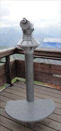 view gallery view galleryNW17.4 km |  Mono - Nebelhorn Gipfel/Peak, Germany, BY Mono - Nebelhorn Gipfel/Peak, Germany, BY
in Coin-Op Binoculars This is a monocular located at Peak of the Nebelhorn Mountain nearby to Oberstdorf, Germany, Bayern. posted by: Tante.Hossi location: Bayern, Germany date approved: 07/14/2011 last visited: 02/28/2014 |
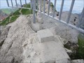 view gallery view galleryNW17.4 km |  TP Nebelhorngipfel - Oberstdorf, Germany, BY TP Nebelhorngipfel - Oberstdorf, Germany, BY
in German Trigonometric Points This is a German Trigpoint located at the peak of the Nebelhorn Mountain near Oberstdorf, Germany, Bayern. posted by: Tante.Hossi location: Bayern, Germany date approved: 07/21/2011 last visited: 02/28/2014 |
 view gallery view gallerySE17.5 km |  Alpincoaster Imst, Tyrol - Austria Alpincoaster Imst, Tyrol - Austria
in Official Local Tourism Attractions Alpincoaster Imst, Tyrol - Austria posted by: luzzi-reloaded location: Tirol, Austria date approved: 03/15/2011 last visited: 07/17/2011 |
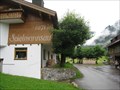
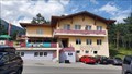 view gallery view gallerySE17.5 km |  Sonneck - Hohe Imst, Tirol, Austria Sonneck - Hohe Imst, Tirol, Austria
in Ski Lodges After a nice day on the slopes OR a walk up the Rosengartenschlucht, the Sonneck (Sun Corner) ski lodge is a nice place for a hot/cold drink and something to eat. posted by: T-Team! location: Tirol, Austria date approved: 08/20/2022 last visited: never |
|