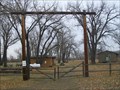
 view gallery view gallery E45.2 km E45.2 km
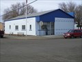
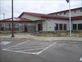
|   Circle, Montana 59215 Circle, Montana 59215
in U.S. Post Offices Small town post office. posted by:  NGComets NGComets location: Montana date approved: 11/01/2012 last visited: never |
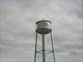 view gallery view galleryE45.2 km |  Watertower, Circle, Montana Watertower, Circle, Montana
in Water Towers Traditional watertower in a small town. posted by: NGComets location: Montana date approved: 11/01/2012 last visited: never |
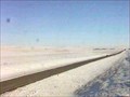 view gallery view gallery S51.7 km S51.7 km
|  Rock Springs Web Camera - Rock Springs, MT Rock Springs Web Camera - Rock Springs, MT
in Web Cameras This is one of 73 (as of February 2017) Road Weather Information System camera sites operated by the Montana Department of Transportation to aid motorists as they make their way across BIG SKY Country. posted by: T0SHEA location: Montana date approved: 02/07/2017 last visited: never |
 view gallery view gallery W56.3 km W56.3 km
|  Indian Country Indian Country
in Montana Historical Markers This historical sign notes the unsettled country near Jordan, Montana during the 1880's mentioning the tribes that were in the area, the coming of white man, cattle, and fenses. posted by: Topper-Tsennya location: Montana date approved: 06/22/2010 last visited: never |
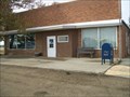 view gallery view gallery NE78.5 km NE78.5 km
| Vida, Montana 59274 in U.S. Post Offices Post office in a very small town. posted by: NGComets location: Montana date approved: 11/01/2012 last visited: never |
 view gallery view gallery N81.8 km N81.8 km
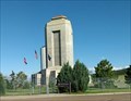
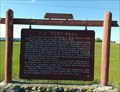
|  Fort Peck Project- Fort Peck, Montana Fort Peck Project- Fort Peck, Montana
in WPA Projects According to the sign, the Fort Peck Project was "the single largest employer of the New Deal" posted by:  Bon Echo Bon Echo location: Montana date approved: 09/22/2018 last visited: never |
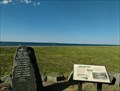 view gallery view galleryN81.8 km |  Fort Peck Dam Landslide Memorial - Fort Peck, Montana Fort Peck Dam Landslide Memorial - Fort Peck, Montana
in Disaster Memorials Signs and memorial stones to remember the events and those who perished in the Fort Peck Dam "Slide of '38" posted by: Bon Echo location: Montana date approved: 10/03/2018 last visited: never |
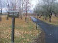 view gallery view galleryN82.2 km |  Beaver Creek Nature Trail, Ft. Peck, Montana Beaver Creek Nature Trail, Ft. Peck, Montana
in Hiking and walking trailheads Approximately 3 miles of paved nature trails winding through and around the local campground. posted by: NGComets location: Montana date approved: 01/07/2013 last visited: never |
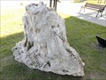 view gallery view galleryN82.4 km |  Petrified Trees - Fort Peck, MT Petrified Trees - Fort Peck, MT
in Paleontology and Fossils Two sections of Petrified Trees at the Fort Peck Interpretive Center posted by: Bon Echo location: Montana date approved: 07/29/2018 last visited: never |
 view gallery view galleryN82.4 km |  ODB 15 - Fort Peck, Montana ODB 15 - Fort Peck, Montana
in U.S. Benchmarks Located on the Fort Peck Spillway posted by: Bon Echo location: Montana date approved: 07/26/2018 last visited: never |
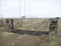
 view gallery view galleryN82.6 km | Old Fort Peck - Fort Peck, MT in Montana Historical Markers Describes the original Fort Peck, which now sits beneath the waters of the Fort Peck Reservoir posted by: Bon Echo location: Montana date approved: 07/23/2018 last visited: never |
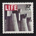 view gallery view galleryN82.6 km |  Spillway Gates, Fort Peck Dam Spillway Gates, Fort Peck Dam
in Philatelic Photographs A section of the spillway for the Fort Peck Dam in eastern Montana graced the cover of the first issue of LIFE magazine. The photograph was taken during construction of the dam in 1936. posted by: hykesj location: Montana date approved: 09/20/2013 last visited: never |
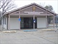
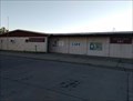 view gallery view galleryN82.7 km | Fort Peck, Montana - 59223 in U.S. Post Offices Small USPS office in Fort Peck MT posted by: Bon Echo location: Montana date approved: 08/02/2018 last visited: never |
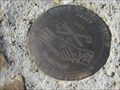 view gallery view galleryN82.9 km | Corps of Discovery II – Milk River, Fort Peck, MT in U.S. Benchmarks Corps of Discovery II – Milk River, Fort Peck, MT, is a 4-inch Lewis and Clark commemorative disk located at the Milk River Observation Point above the confluence of the Missouri and Milk Rivers near the Fort Peck Dam in MT. posted by: seventhings location: Montana date approved: 09/09/2006 last visited: 05/12/2007 |
 view gallery view galleryN83.8 km |  Ft. Peck State Fish Hatchery, Ft. Peck, Montana Ft. Peck State Fish Hatchery, Ft. Peck, Montana
in Fish Hatcheries Passed in 1999, House Bill 20 authorized a Warm Water Sport Fish Surcharge and a multi-species hatchery for the State of Montana to be located at Fort Peck. The visitors center is open 7am-4pm Monday through Friday and 8am-5pm Saturday and Sunday. posted by: NGComets location: Montana date approved: 11/01/2012 last visited: never |
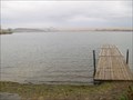 view gallery view galleryN84.2 km |  Roundhouse Point Boat Dock, Ft. Peck, Montana Roundhouse Point Boat Dock, Ft. Peck, Montana
in Boat Ramps One of several boat docks on Montana's largest body of water, Lake Peck. posted by: NGComets location: Montana date approved: 11/06/2012 last visited: never |
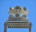 view gallery view gallery SE84.8 km SE84.8 km
|  Terry Warning Siren Terry Warning Siren
in Outdoor Warning Sirens This Outdoor Warning Siren is mounted on a pair of wooden poles south of Park Street behind the Prairie County Health Department office at 203 S Logan Avenue in Terry Montana. posted by: brwhiz location: Montana date approved: 07/23/2013 last visited: never |
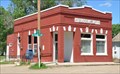
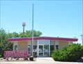 view gallery view gallerySE84.8 km | Terry, Montana 59349 in U.S. Post Offices This Post Office is located at 303 Logan Avenue in Terry, Montana. posted by: brwhiz location: Montana date approved: 06/28/2013 last visited: never |
 view gallery view galleryN85.1 km |  Boy Scout Park, Ft. Peck, Montana Boy Scout Park, Ft. Peck, Montana
in Boy Scout Camps A rustic camp on Lake Peck, Montana. posted by: NGComets location: Montana date approved: 02/17/2013 last visited: never |
 view gallery view galleryN85.9 km | Frazer, Montana 59225 in U.S. Post Offices Small town post office. posted by: NGComets location: Montana date approved: 11/01/2012 last visited: never |
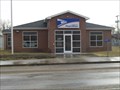
 view gallery view gallerySE93.5 km | Fallon, Montana 59326 in U.S. Post Offices This Post Office is located at 500 N Railway Avenue in Fallon, Montana. posted by: brwhiz location: Montana date approved: 06/28/2013 last visited: never |
 view gallery view galleryN94.8 km | Nashua, Montana 59248 in U.S. Post Offices Post office in a very small town. posted by: NGComets location: Montana date approved: 11/02/2012 last visited: 07/14/2018 |
 view gallery view galleryN95.9 km |  Nashua Cemetery, Nashua, Montana Nashua Cemetery, Nashua, Montana
in Worldwide Cemeteries Small cemetery along Highway 2 in Montana with about 150 graves. posted by: NGComets location: Montana date approved: 01/09/2013 last visited: never |
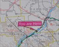 view gallery view gallerySE96.7 km |  Bad Route Rest Area Bad Route Rest Area
in 'You Are Here' Maps You Are Here at the Bad Route Rest Area located on the southeast side of Interstate Highway 94 Exit 192, about 18 miles southwest of Glendive, Montana. posted by: brwhiz location: Montana date approved: 07/30/2013 last visited: 09/11/2018 |
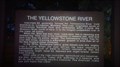 view gallery view gallerySE96.7 km | The Yellowstone River - Montan Historical Marker in Montana Historical Markers A quick read over of this Montana Historical marker, might be what caused so many people to *MISS* the major typo on this sign located a few miles west of Glendive, Montana. posted by: Topper-Tsennya location: Montana date approved: 07/11/2010 last visited: 08/14/2022 |
|